Difference between revisions of "Symbology"
(→Land Release Web Symbols) |
|||
| (43 intermediate revisions by 4 users not shown) | |||
| Line 1: | Line 1: | ||
| − | Based on the Study Cartographic Recommendations for Humanitarian Demining Map Symbols in the Information Management System for Mine Action (IMSMA), | + | Based on the Study [http://www.gichd.org/fileadmin/GICHD-resources/rec-documents/IMSMA-Symbology-FinalReport.pdf 'Cartographic Recommendations for Humanitarian Demining Map Symbols in the Information Management System for Mine Action (IMSMA)'], a first set of symbols was developed in 2005 for inclusion in {{IMSMANG}}. The IMSMA symbology may be found in ''C:\IMSMAng\server\gis\maps\IMSMA.style''. |
| − | + | ==Land Release Symbology== | |
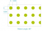
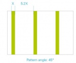
| + | The GICHD has developed a new set of mine action symbols that is in line with the IMAS 07.11 Land Release. The 32 point and polygon symbols capture the main attribute values for various land categories and mine action activities required to depict the land release process on maps. | ||
| − | + | For usage in web applications, the image URLs of point symbols as well as a detailed description of the polygon symbols are available in the table below. | |
| + | |||
| + | A detailed description on the methodology and the design considerations applied to develop the symbols, as well as guidance on how to implement the symbology in GIS products is provided in the new Technical Note 07.11/01-2016 Land Release Symbology. The symbols are further included as an annex to the IMAS 07.11 Land Release. These documents are available on the [http://www.mineactionstandards.org/ IMAS Website] | ||
| + | |||
| + | The '''[[Media:LR Symbology.zip |symbols]]''' are available in ArcGIS ''style'' format. | ||
| − | |||
{| class="wikitable" | {| class="wikitable" | ||
|- | |- | ||
| − | ! Feature!! Attribute!!Value !! Symbol !! URL | + | ! Feature!! Attribute!!Value !! Symbol !! Point symbol URL / Polygon symbol description |
|- | |- | ||
| − | |rowspan=" | + | |rowspan="4"|Land |
|rowspan="4"|Classification | |rowspan="4"|Classification | ||
|rowspan="2"|CHA | |rowspan="2"|CHA | ||
|[[File:Hazard_CHA_polygon.png|100px]] | |[[File:Hazard_CHA_polygon.png|100px]] | ||
| | | | ||
| + | {| | ||
| + | |- | ||
| + | | Fill colour || | ||
| + | CMYK 0 100 100 0 <br /> | ||
| + | RGB 255 0 0<br /> | ||
| + | HEX FF0000 | ||
| + | |- | ||
| + | | Transparency || 50% | ||
| + | |} | ||
|- | |- | ||
|[[File:CHA skull final.png|100px]] | |[[File:CHA skull final.png|100px]] | ||
| Line 22: | Line 35: | ||
|[[File:Hazard_SHA_polygon.png|100px]] | |[[File:Hazard_SHA_polygon.png|100px]] | ||
| | | | ||
| + | {| | ||
| + | |- | ||
| + | | Fill colour || | ||
| + | CMYK 0 40 100 0 <br /> | ||
| + | RGB 244 167 24<br /> | ||
| + | HEX F4A718 | ||
| + | |- | ||
| + | | Transparency || 50% | ||
| + | |} | ||
|- | |- | ||
|[[File:SHA skull final.png|100px]] | |[[File:SHA skull final.png|100px]] | ||
|http://mwiki.gichd.org/mediawiki/images/6/67/SHA_skull_final.png | |http://mwiki.gichd.org/mediawiki/images/6/67/SHA_skull_final.png | ||
|- | |- | ||
| + | |rowspan="6"|Land | ||
|rowspan="6"|Status | |rowspan="6"|Status | ||
|rowspan="2"|Open | |rowspan="2"|Open | ||
|[[File:Hazard_Status_Open_Polygon.png|100px]] | |[[File:Hazard_Status_Open_Polygon.png|100px]] | ||
| | | | ||
| + | {| | ||
| + | |- | ||
| + | | Outline colour || | ||
| + | CMYK 0 100 100 0 <br /> | ||
| + | RGB 255 0 0<br /> | ||
| + | HEX FF0000 | ||
| + | |- | ||
| + | | Outline|| Continuous | ||
| + | |} | ||
|- | |- | ||
|[[File:Hazard_Status-open_final.png|100px]] | |[[File:Hazard_Status-open_final.png|100px]] | ||
| Line 37: | Line 69: | ||
|[[File:Hazard_Status_Worked_On_Polygon.png|100px]] | |[[File:Hazard_Status_Worked_On_Polygon.png|100px]] | ||
| | | | ||
| + | {| | ||
| + | |- | ||
| + | | Outline colour || | ||
| + | CMYK 0 40 100 0 <br /> | ||
| + | RGB 244 167 24<br /> | ||
| + | HEX F4A718 | ||
| + | |- | ||
| + | | Outline pattern|| [[File:WorkedOn_outlinePattern.jpg|150px]] | ||
| + | |} | ||
|- | |- | ||
|[[File:Hazard_Status-worked_on_final.png|100px]] | |[[File:Hazard_Status-worked_on_final.png|100px]] | ||
| Line 44: | Line 85: | ||
|[[File:Hazard_Status_closed_Polygon.png|100px]] | |[[File:Hazard_Status_closed_Polygon.png|100px]] | ||
| | | | ||
| + | {| | ||
| + | |- | ||
| + | | Outline colour || | ||
| + | CMYK 40 0 100 0 <br /> | ||
| + | RGB 192 218 48<br /> | ||
| + | HEX C0DA30 | ||
| + | |- | ||
| + | | Outline|| Continuous | ||
| + | |} | ||
|- | |- | ||
|[[File:Cancelled-reduced-cleared final.png|100px]] | |[[File:Cancelled-reduced-cleared final.png|100px]] | ||
|http://mwiki.gichd.org/mediawiki/images/c/cf/Cancelled-reduced-cleared_final.png | |http://mwiki.gichd.org/mediawiki/images/c/cf/Cancelled-reduced-cleared_final.png | ||
|- | |- | ||
| − | |rowspan=" | + | |rowspan="6"|Land |
| + | |rowspan="6"|Type of contamination | ||
|APM | |APM | ||
|[[File:AP mine final.png|100px]] | |[[File:AP mine final.png|100px]] | ||
| Line 61: | Line 112: | ||
|http://mwiki.gichd.org/mediawiki/images/9/96/UXO_final.png | |http://mwiki.gichd.org/mediawiki/images/9/96/UXO_final.png | ||
|- | |- | ||
| − | |Cluster | + | |Cluster Munition |
|[[File:Cluster munition final.png|100px]] | |[[File:Cluster munition final.png|100px]] | ||
|http://mwiki.gichd.org/mediawiki/images/0/01/Cluster_munition_final.png | |http://mwiki.gichd.org/mediawiki/images/0/01/Cluster_munition_final.png | ||
| Line 68: | Line 119: | ||
|[[File:AXO final.png|100px]] | |[[File:AXO final.png|100px]] | ||
| http://mwiki.gichd.org/mediawiki/images/3/39/AXO_final.png | | http://mwiki.gichd.org/mediawiki/images/3/39/AXO_final.png | ||
| − | |||
| − | |||
| − | |||
| − | |||
|- | |- | ||
|Other/Unknown | |Other/Unknown | ||
| Line 77: | Line 124: | ||
| http://mwiki.gichd.org/mediawiki/images/a/a7/Unknown_final.png | | http://mwiki.gichd.org/mediawiki/images/a/a7/Unknown_final.png | ||
|- | |- | ||
| + | |rowspan="6"|Land | ||
|rowspan="6"|Land Release product | |rowspan="6"|Land Release product | ||
|rowspan="2"|Cancelled | |rowspan="2"|Cancelled | ||
|[[File:Hazard_cancelled_polygon.png|100px]] | |[[File:Hazard_cancelled_polygon.png|100px]] | ||
| | | | ||
| + | {| | ||
| + | |- | ||
| + | | Colour || | ||
| + | CMYK 40 0 100 0 <br /> | ||
| + | RGB 192 218 48<br /> | ||
| + | HEX C0DA30 | ||
| + | |- | ||
| + | | Fill pattern|| [[File:Cancelled_OutlinePattern.jpg|150px]] | ||
| + | |- | ||
| + | |Outline ||Continuous | ||
| + | |} | ||
|- | |- | ||
|[[File:Cancelled-reduced-cleared final.png|100px]] | |[[File:Cancelled-reduced-cleared final.png|100px]] | ||
| Line 88: | Line 147: | ||
|[[File:Hazard_reduced_polygon.png|100px]] | |[[File:Hazard_reduced_polygon.png|100px]] | ||
| | | | ||
| + | {| | ||
| + | |- | ||
| + | | Colour || | ||
| + | CMYK 40 0 100 0<br /> | ||
| + | RGB 192 218 48<br /> | ||
| + | HEX C0DA30 | ||
| + | |- | ||
| + | | Fill pattern|| [[File:Reduced_Pattern.jpg|150px]] | ||
| + | |- | ||
| + | |Outline ||Continuous | ||
| + | |} | ||
|- | |- | ||
|[[File:Cancelled-reduced-cleared final.png|100px]] | |[[File:Cancelled-reduced-cleared final.png|100px]] | ||
| Line 95: | Line 165: | ||
|[[File:Hazard_cleared_polygon.png|100px]] | |[[File:Hazard_cleared_polygon.png|100px]] | ||
| | | | ||
| + | {| | ||
| + | |- | ||
| + | | Colour || | ||
| + | CMYK 40 0 100 0<br /> | ||
| + | RGB 192 218 48<br /> | ||
| + | HEX C0DA30 | ||
| + | |- | ||
| + | |Transparency|| 50% | ||
| + | |- | ||
| + | |Outline ||Continuous | ||
| + | |} | ||
|- | |- | ||
|[[File:Cancelled-reduced-cleared final.png|100px]] | |[[File:Cancelled-reduced-cleared final.png|100px]] | ||
|http://mwiki.gichd.org/mediawiki/images/c/cf/Cancelled-reduced-cleared_final.png | |http://mwiki.gichd.org/mediawiki/images/c/cf/Cancelled-reduced-cleared_final.png | ||
|- | |- | ||
| − | |rowspan=" | + | |rowspan="4"|Activity |
|rowspan="4"|Type | |rowspan="4"|Type | ||
|EOD Spot Task | |EOD Spot Task | ||
| Line 117: | Line 198: | ||
|http://mwiki.gichd.org/mediawiki/images/a/a6/Clearance_final.png | |http://mwiki.gichd.org/mediawiki/images/a/a6/Clearance_final.png | ||
|- | |- | ||
| + | |rowspan="3"|Activity | ||
|rowspan="3"|Method | |rowspan="3"|Method | ||
|Mechanical | |Mechanical | ||
| Line 130: | Line 212: | ||
|http://mwiki.gichd.org/mediawiki/images/5/5f/Animal_demining_final.png | |http://mwiki.gichd.org/mediawiki/images/5/5f/Animal_demining_final.png | ||
|- | |- | ||
| + | |rowspan="3"|Activity | ||
|rowspan="3"|Status | |rowspan="3"|Status | ||
|Planned | |Planned | ||
| Line 143: | Line 226: | ||
|http://mwiki.gichd.org/mediawiki/images/9/99/Activity-completed_final.png | |http://mwiki.gichd.org/mediawiki/images/9/99/Activity-completed_final.png | ||
|- | |- | ||
| + | |rowspan="2"|Activity | ||
|rowspan="2"|Spatial Dimension | |rowspan="2"|Spatial Dimension | ||
|Surface | |Surface | ||
| Line 152: | Line 236: | ||
|http://mwiki.gichd.org/mediawiki/images/6/6c/Sub-surface_final.png | |http://mwiki.gichd.org/mediawiki/images/6/6c/Sub-surface_final.png | ||
|- | |- | ||
| + | |rowspan="1"|Point type | ||
|Evidences | |Evidences | ||
|Evidence Point | |Evidence Point | ||
| Line 159: | Line 244: | ||
{{NavBox HowTo Viewing and Browsing}} | {{NavBox HowTo Viewing and Browsing}} | ||
| + | [[Category:CRI]] | ||
Latest revision as of 09:10, 22 October 2018
Based on the Study 'Cartographic Recommendations for Humanitarian Demining Map Symbols in the Information Management System for Mine Action (IMSMA)', a first set of symbols was developed in 2005 for inclusion in IMSMANG. The IMSMA symbology may be found in C:\IMSMAng\server\gis\maps\IMSMA.style.
Land Release Symbology
The GICHD has developed a new set of mine action symbols that is in line with the IMAS 07.11 Land Release. The 32 point and polygon symbols capture the main attribute values for various land categories and mine action activities required to depict the land release process on maps.
For usage in web applications, the image URLs of point symbols as well as a detailed description of the polygon symbols are available in the table below.
A detailed description on the methodology and the design considerations applied to develop the symbols, as well as guidance on how to implement the symbology in GIS products is provided in the new Technical Note 07.11/01-2016 Land Release Symbology. The symbols are further included as an annex to the IMAS 07.11 Land Release. These documents are available on the IMAS Website
The symbols are available in ArcGIS style format.
| |||||||||||||||||||||


