Difference between revisions of "Delete a Coordinate System"
From IMSMA Wiki
(Created page with "<table cellspacing="5" cellpadding="0" style="float: right; clear: right; color: black; background: #f9f9f9; border: 1px solid #aaa; width: 22em; margin: 0 0 1.0em 1.0em; padd...") |
|||
| (17 intermediate revisions by 5 users not shown) | |||
| Line 1: | Line 1: | ||
| − | < | + | <ol> |
| − | < | + | <li>In the '''Customisation''' menu → '''Coordinate System Manager'''. |
| − | < | + | [[Image:UserManual CoordinateSystemManagerWindow.png|450px|center]]<br/> |
| − | + | <li>Select the row associated with the coordinate system that you would like to delete.</li> | |
| − | < | + | <li>Click the [[Image:EcksButton.png]] button. </li> |
| − | + | [[Image:Delete coord sys.png|400px|center]]<br/> | |
| − | + | <li>Click the '''Yes''' button.</li> | |
| − | [[ | + | </ol> |
| − | |||
| − | |||
| − | + | {{Note|It is not possible to delete MGRS and WGS 1984 coordinate systems from the list.}} | |
| − | |||
| − | |||
| − | { | + | {{NavBox HowTo Setting up Maps}} |
| − | |||
| − | |||
| − | |||
| − | + | [[Category:CRI]] | |
| − | |||
| − | |||
| − | |||
| − | |||
| − | |||
| − | |||
| − | |||
Latest revision as of 20:25, 19 June 2017
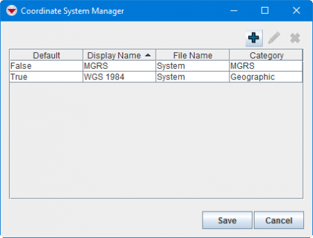
- In the Customisation menu → Coordinate System Manager.
- Select the row associated with the coordinate system that you would like to delete.
- Click the
 button.
 - Click the Yes button.
| |
It is not possible to delete MGRS and WGS 1984 coordinate systems from the list. |
| |||||||||||||

