How to make polygons look different in IMSMA.mxd
| An alternative solution to change colour of the polygons is to use Poly Property that makes it possible as well to distinguish between polygons that belong to the same report. |
If you would like to change the existing symbology, you need to use ArcGIS software to update IMSMA.mxd which is located in C:\IMSMAng\server\gis\maps folder.
In IMSMANG version 6.0 it is not possible to change the IMSMA.mxd to show different colours of the polygon based on Type, Status, etc. i.e. it is not possible to have red for Open, Orange for Worked on and Red for Closed. But it is possible to change how to polygon looks like in IMSMANG.
Steps
As an example, Land by Status theme will be used. The use case could be that the users wanted to have the polygons filled with diagonal stripes instead of filled solid.
- This is how the Map Display Window inside IMSMA looks like before any changes on the .mxd file:
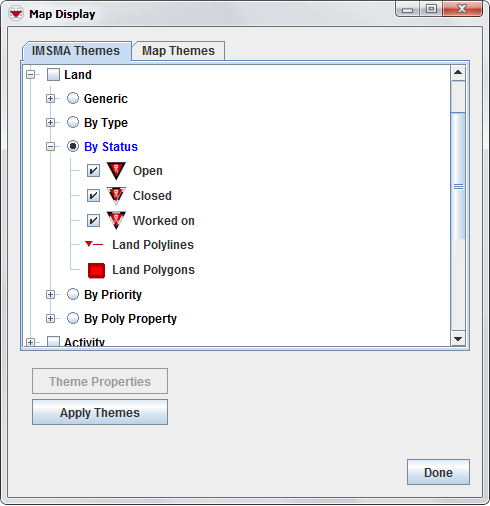
IMSMA layer Land - by Status
- Open IMSMA.mxd with ArcMap and go to Land by Status layer. Double-click on the layer or right-click and choose Properties.
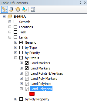
IMSMA layer Land - by Status
- The following window displays.
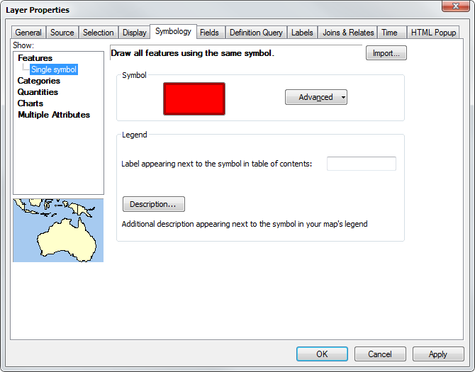
Layer Property window - Symbology tab
- Click on the Polygon.
- The following window displays.
- Note the width and colour of the Outline.
- Scroll down in the style list and select 10% Simple hatch fill.
- Click on OK.
- Click on OK.
- Save the IMSMA.mxd and close ArcMap.
- Rename your background mxd. This mxd must not previously been merged/imported into IMSMANG.
- In the IMSMA client (if your configuration is client/server then start the IMSMA client on the server computer) go to File → Import → Map.
- Import the background map which will be merged with the updated IMSMA.mxd.
- Verify in Map Display that the changes are applied.
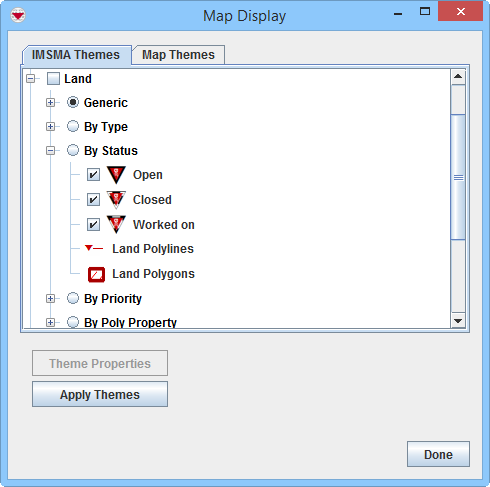
IMSMA layer Land - by Status


Symbology selector window

IMSMA layer Land - by Status after edit

{{#switch:|subgroup|child=|none=|#default=
{{#if:|<th scope="col" style="border-left:2px solid #fdfdfd;width:100%;|}}{{#if:|{{#if:Customising IMSMANG|}}}}{{#if:{{#switch:{{#if:|{{{border}}}|child}}|subgroup|child=|none=|#default=| }}<table cellspacing="0" class="nowraplinks hlist {{#if:Customising IMSMANG|{{#switch:autocollapse|plain|off=|#default=collapsible {{#if:autocollapse|autocollapse|autocollapse}}}}}} {{#switch:|subgroup|child|none=navbox-subgroup" style="border-spacing:0;;|#default=navbox-inner" style="border-spacing:0;background:transparent;color:inherit}};;">{{#if:Customising IMSMANG| | |
{{{above}}} |
| }}{{#if:|{{#if:|<th scope="col" style="border-left:2px solid #fdfdfd;width:100%;|}}{{#if:|{{#if:|}}}}{{#if:Import an IMSMA Map · Modify an IMSMA Map|{{#if:|}}{{#if:|}}{{#if:{{#if:Background map| Background map }}|<td style="text-align:left;border-left-width:2px;border-left-style:solid;|{{#if:|}}}}{{#if:Change existing symbol in IMSMA.mxd · Add a new symbol to IMSMA.mxd · Change Visible Scale Range · How to make polygons look different in IMSMA.mxd · Customise Sub-Themes in IMSMA · How to work with Sub-Themes in IMSMA.mxd|{{#if:Import an IMSMA Map · Modify an IMSMA Map|}}{{#if:{{#if:IMSMA.mxd|}}|<td style="text-align:left;border-left-width:2px;border-left-style:solid;|}}{{#if:Add a Coordinate System · Change the Display Name of a Coordinate System · Delete a Coordinate System · Set Default Coordinate System|{{#if:Import an IMSMA Map · Modify an IMSMA MapChange existing symbol in IMSMA.mxd · Add a new symbol to IMSMA.mxd · Change Visible Scale Range · How to make polygons look different in IMSMA.mxd · Customise Sub-Themes in IMSMA · How to work with Sub-Themes in IMSMA.mxd|}}{{#if:{{#if:Coordinate system|}}|<td style="text-align:left;border-left-width:2px;border-left-style:solid;|}}{{#if:|{{#if:{{#if:|{{{group4}}} }}|<td style="text-align:left;border-left-width:2px;border-left-style:solid;|}}{{#if:|{{#if:{{#if:|{{{group5}}} }}|<td style="text-align:left;border-left-width:2px;border-left-style:solid;|}}{{#if:|{{#if:{{#if:|{{{group6}}} }}|<td style="text-align:left;border-left-width:2px;border-left-style:solid;|}}{{#if:|{{#if:{{#if:|{{{group7}}} }}|<td style="text-align:left;border-left-width:2px;border-left-style:solid;|}}{{#if:|{{#if:{{#if:|{{{group8}}} }}|<td style="text-align:left;border-left-width:2px;border-left-style:solid;|}}{{#if:|{{#if:{{#if:|{{{group9}}} }}|<td style="text-align:left;border-left-width:2px;border-left-style:solid;|}}{{#if:|{{#if:{{#if:|{{{group10}}} }}|<td style="text-align:left;border-left-width:2px;border-left-style:solid;|}}{{#if:|{{#if:{{#if:|{{{group11}}} }}|<td style="text-align:left;border-left-width:2px;border-left-style:solid;|}}{{#if:|{{#if:{{#if:|{{{group12}}} }}|<td style="text-align:left;border-left-width:2px;border-left-style:solid;|}}{{#if:|{{#if:{{#if:|{{{group13}}} }}|<td style="text-align:left;border-left-width:2px;border-left-style:solid;|}}{{#if:|{{#if:{{#if:|{{{group14}}} }}|<td style="text-align:left;border-left-width:2px;border-left-style:solid;|}}{{#if:|{{#if:{{#if:|{{{group15}}} }}|<td style="text-align:left;border-left-width:2px;border-left-style:solid;|}}{{#if:|{{#if:{{#if:|{{{group16}}} }}|<td style="text-align:left;border-left-width:2px;border-left-style:solid;|}}{{#if:|{{#if:{{#if:|{{{group17}}} }}|<td style="text-align:left;border-left-width:2px;border-left-style:solid;|}}{{#if:|{{#if:{{#if:|{{{group18}}} }}|<td style="text-align:left;border-left-width:2px;border-left-style:solid;|}}{{#if:|{{#if:{{#if:|{{{group19}}} }}|<td style="text-align:left;border-left-width:2px;border-left-style:solid;|}}{{#if:|{{#if:{{#if:|{{{group20}}} }}|<td style="text-align:left;border-left-width:2px;border-left-style:solid;|}}{{#if:|{{#if:Import an IMSMA Map · Modify an IMSMA MapChange existing symbol in IMSMA.mxd · Add a new symbol to IMSMA.mxd · Change Visible Scale Range · How to make polygons look different in IMSMA.mxd · Customise Sub-Themes in IMSMA · How to work with Sub-Themes in IMSMA.mxdAdd a Coordinate System · Change the Display Name of a Coordinate System · Delete a Coordinate System · Set Default Coordinate System|}}}}
|none=|#default= | ||||||||||||||||||||||||||||||||||||||||||||||||||||||||||||||||||||||||||||||||||||||||
}}{{#ifeq:|Template|{{#ifeq:{{#if:|{{{border}}}|child}}|child||{{#ifeq:{{#if:|{{{border}}}|child}}|subgroup||{{#switch:how to make polygons look different in imsma.mxd
|doc
|sandbox
|testcases =
|#default = {{#switch:
 |plainlist
 |hlist
 |hlist hnum
 |hlist vcard
 |vcard hlist =
 |#default =
 }}
}}
}}}}}}|{{#if:Customising IMSMANG|}}{{#if:|
}}{{#if:Setting-up Maps and Coordinate Systems|Setting-up Maps and Coordinate Systems<td style="text-align:left;border-left-width:2px;border-left-style:solid;|
|none=|#default=
| }}{{#if:|{{#if:|<th scope="col" style="border-left:2px solid #fdfdfd;width:100%;|}}{{#if:|{{#if:|}}}}{{#if:Import an IMSMA Map · Modify an IMSMA Map|{{#if:|}}{{#if:|}}{{#if:{{#if:Background map| Background map }}|<td style="text-align:left;border-left-width:2px;border-left-style:solid;|{{#if:|}}}}{{#if:Change existing symbol in IMSMA.mxd · Add a new symbol to IMSMA.mxd · Change Visible Scale Range · How to make polygons look different in IMSMA.mxd · Customise Sub-Themes in IMSMA · How to work with Sub-Themes in IMSMA.mxd|{{#if:Import an IMSMA Map · Modify an IMSMA Map|}}{{#if:{{#if:IMSMA.mxd|}}|<td style="text-align:left;border-left-width:2px;border-left-style:solid;|}}{{#if:Add a Coordinate System · Change the Display Name of a Coordinate System · Delete a Coordinate System · Set Default Coordinate System|{{#if:Import an IMSMA Map · Modify an IMSMA MapChange existing symbol in IMSMA.mxd · Add a new symbol to IMSMA.mxd · Change Visible Scale Range · How to make polygons look different in IMSMA.mxd · Customise Sub-Themes in IMSMA · How to work with Sub-Themes in IMSMA.mxd|}}{{#if:{{#if:Coordinate system|}}|<td style="text-align:left;border-left-width:2px;border-left-style:solid;|}}{{#if:|{{#if:{{#if:|{{{group4}}} }}|<td style="text-align:left;border-left-width:2px;border-left-style:solid;|}}{{#if:|{{#if:{{#if:|{{{group5}}} }}|<td style="text-align:left;border-left-width:2px;border-left-style:solid;|}}{{#if:|{{#if:{{#if:|{{{group6}}} }}|<td style="text-align:left;border-left-width:2px;border-left-style:solid;|}}{{#if:|{{#if:{{#if:|{{{group7}}} }}|<td style="text-align:left;border-left-width:2px;border-left-style:solid;|}}{{#if:|{{#if:{{#if:|{{{group8}}} }}|<td style="text-align:left;border-left-width:2px;border-left-style:solid;|}}{{#if:|{{#if:{{#if:|{{{group9}}} }}|<td style="text-align:left;border-left-width:2px;border-left-style:solid;|}}{{#if:|{{#if:{{#if:|{{{group10}}} }}|<td style="text-align:left;border-left-width:2px;border-left-style:solid;|}}{{#if:|{{#if:{{#if:|{{{group11}}} }}|<td style="text-align:left;border-left-width:2px;border-left-style:solid;|}}{{#if:|{{#if:{{#if:|{{{group12}}} }}|<td style="text-align:left;border-left-width:2px;border-left-style:solid;|}}{{#if:|{{#if:{{#if:|{{{group13}}} }}|<td style="text-align:left;border-left-width:2px;border-left-style:solid;|}}{{#if:|{{#if:{{#if:|{{{group14}}} }}|<td style="text-align:left;border-left-width:2px;border-left-style:solid;|}}{{#if:|{{#if:{{#if:|{{{group15}}} }}|<td style="text-align:left;border-left-width:2px;border-left-style:solid;|}}{{#if:|{{#if:{{#if:|{{{group16}}} }}|<td style="text-align:left;border-left-width:2px;border-left-style:solid;|}}{{#if:|{{#if:{{#if:|{{{group17}}} }}|<td style="text-align:left;border-left-width:2px;border-left-style:solid;|}}{{#if:|{{#if:{{#if:|{{{group18}}} }}|<td style="text-align:left;border-left-width:2px;border-left-style:solid;|}}{{#if:|{{#if:{{#if:|{{{group19}}} }}|<td style="text-align:left;border-left-width:2px;border-left-style:solid;|}}{{#if:|{{#if:{{#if:|{{{group20}}} }}|<td style="text-align:left;border-left-width:2px;border-left-style:solid;|}}{{#if:|{{#if:Import an IMSMA Map · Modify an IMSMA MapChange existing symbol in IMSMA.mxd · Add a new symbol to IMSMA.mxd · Change Visible Scale Range · How to make polygons look different in IMSMA.mxd · Customise Sub-Themes in IMSMA · How to work with Sub-Themes in IMSMA.mxdAdd a Coordinate System · Change the Display Name of a Coordinate System · Delete a Coordinate System · Set Default Coordinate System|}}}}
|none=|#default= | ||||||||||||||||||||||||||||||||||||||||||||||||||||||||||||||||||||||||||||||||||||||||
}}{{#ifeq:|Template|{{#ifeq:{{#if:|{{{border}}}|child}}|child||{{#ifeq:{{#if:|{{{border}}}|child}}|subgroup||{{#switch:how to make polygons look different in imsma.mxd
|doc
|sandbox
|testcases =
|#default = {{#switch:
 |plainlist
 |hlist
 |hlist hnum
 |hlist vcard
 |vcard hlist =
 |#default =
 }}
}}
}}}}}}{{#if:|
}}}}{{#if:|{{#if:Customising IMSMANG{{#switch:{{#if:|{{{border}}}|child}}|subgroup|child=|none=|#default=
| }}{{#if:|{{#if:|<th scope="col" style="border-left:2px solid #fdfdfd;width:100%;|}}{{#if:|{{#if:|}}}}{{#if:Import an IMSMA Map · Modify an IMSMA Map|{{#if:|}}{{#if:|}}{{#if:{{#if:Background map| Background map }}|<td style="text-align:left;border-left-width:2px;border-left-style:solid;|{{#if:|}}}}{{#if:Change existing symbol in IMSMA.mxd · Add a new symbol to IMSMA.mxd · Change Visible Scale Range · How to make polygons look different in IMSMA.mxd · Customise Sub-Themes in IMSMA · How to work with Sub-Themes in IMSMA.mxd|{{#if:Import an IMSMA Map · Modify an IMSMA Map|}}{{#if:{{#if:IMSMA.mxd|}}|<td style="text-align:left;border-left-width:2px;border-left-style:solid;|}}{{#if:Add a Coordinate System · Change the Display Name of a Coordinate System · Delete a Coordinate System · Set Default Coordinate System|{{#if:Import an IMSMA Map · Modify an IMSMA MapChange existing symbol in IMSMA.mxd · Add a new symbol to IMSMA.mxd · Change Visible Scale Range · How to make polygons look different in IMSMA.mxd · Customise Sub-Themes in IMSMA · How to work with Sub-Themes in IMSMA.mxd|}}{{#if:{{#if:Coordinate system|}}|<td style="text-align:left;border-left-width:2px;border-left-style:solid;|}}{{#if:|{{#if:{{#if:|{{{group4}}} }}|<td style="text-align:left;border-left-width:2px;border-left-style:solid;|}}{{#if:|{{#if:{{#if:|{{{group5}}} }}|<td style="text-align:left;border-left-width:2px;border-left-style:solid;|}}{{#if:|{{#if:{{#if:|{{{group6}}} }}|<td style="text-align:left;border-left-width:2px;border-left-style:solid;|}}{{#if:|{{#if:{{#if:|{{{group7}}} }}|<td style="text-align:left;border-left-width:2px;border-left-style:solid;|}}{{#if:|{{#if:{{#if:|{{{group8}}} }}|<td style="text-align:left;border-left-width:2px;border-left-style:solid;|}}{{#if:|{{#if:{{#if:|{{{group9}}} }}|<td style="text-align:left;border-left-width:2px;border-left-style:solid;|}}{{#if:|{{#if:{{#if:|{{{group10}}} }}|<td style="text-align:left;border-left-width:2px;border-left-style:solid;|}}{{#if:|{{#if:{{#if:|{{{group11}}} }}|<td style="text-align:left;border-left-width:2px;border-left-style:solid;|}}{{#if:|{{#if:{{#if:|{{{group12}}} }}|<td style="text-align:left;border-left-width:2px;border-left-style:solid;|}}{{#if:|{{#if:{{#if:|{{{group13}}} }}|<td style="text-align:left;border-left-width:2px;border-left-style:solid;|}}{{#if:|{{#if:{{#if:|{{{group14}}} }}|<td style="text-align:left;border-left-width:2px;border-left-style:solid;|}}{{#if:|{{#if:{{#if:|{{{group15}}} }}|<td style="text-align:left;border-left-width:2px;border-left-style:solid;|}}{{#if:|{{#if:{{#if:|{{{group16}}} }}|<td style="text-align:left;border-left-width:2px;border-left-style:solid;|}}{{#if:|{{#if:{{#if:|{{{group17}}} }}|<td style="text-align:left;border-left-width:2px;border-left-style:solid;|}}{{#if:|{{#if:{{#if:|{{{group18}}} }}|<td style="text-align:left;border-left-width:2px;border-left-style:solid;|}}{{#if:|{{#if:{{#if:|{{{group19}}} }}|<td style="text-align:left;border-left-width:2px;border-left-style:solid;|}}{{#if:|{{#if:{{#if:|{{{group20}}} }}|<td style="text-align:left;border-left-width:2px;border-left-style:solid;|}}{{#if:|{{#if:Import an IMSMA Map · Modify an IMSMA MapChange existing symbol in IMSMA.mxd · Add a new symbol to IMSMA.mxd · Change Visible Scale Range · How to make polygons look different in IMSMA.mxd · Customise Sub-Themes in IMSMA · How to work with Sub-Themes in IMSMA.mxdAdd a Coordinate System · Change the Display Name of a Coordinate System · Delete a Coordinate System · Set Default Coordinate System|}}}}
|none=|#default= | ||||||||||||||||||||||||||||||||||||||||||||||||||||||||||||||||||||||||||||||||||||||||
}}{{#ifeq:|Template|{{#ifeq:{{#if:|{{{border}}}|child}}|child||{{#ifeq:{{#if:|{{{border}}}|child}}|subgroup||{{#switch:how to make polygons look different in imsma.mxd
|doc
|sandbox
|testcases =
|#default = {{#switch:
 |plainlist
 |hlist
 |hlist hnum
 |hlist vcard
 |vcard hlist =
 |#default =
 }}
}}
}}}}}}|}}{{#if:|{{{group2}}}<td style="text-align:left;border-left-width:2px;border-left-style:solid;|
}}{{#if:|{{#if:Customising IMSMANG{{#switch:{{#if:|{{{border}}}|child}}|subgroup|child=|none=|#default=
| }}{{#if:|{{#if:|<th scope="col" style="border-left:2px solid #fdfdfd;width:100%;|}}{{#if:|{{#if:|}}}}{{#if:Import an IMSMA Map · Modify an IMSMA Map|{{#if:|}}{{#if:|}}{{#if:{{#if:Background map| Background map }}|<td style="text-align:left;border-left-width:2px;border-left-style:solid;|{{#if:|}}}}{{#if:Change existing symbol in IMSMA.mxd · Add a new symbol to IMSMA.mxd · Change Visible Scale Range · How to make polygons look different in IMSMA.mxd · Customise Sub-Themes in IMSMA · How to work with Sub-Themes in IMSMA.mxd|{{#if:Import an IMSMA Map · Modify an IMSMA Map|}}{{#if:{{#if:IMSMA.mxd|}}|<td style="text-align:left;border-left-width:2px;border-left-style:solid;|}}{{#if:Add a Coordinate System · Change the Display Name of a Coordinate System · Delete a Coordinate System · Set Default Coordinate System|{{#if:Import an IMSMA Map · Modify an IMSMA MapChange existing symbol in IMSMA.mxd · Add a new symbol to IMSMA.mxd · Change Visible Scale Range · How to make polygons look different in IMSMA.mxd · Customise Sub-Themes in IMSMA · How to work with Sub-Themes in IMSMA.mxd|}}{{#if:{{#if:Coordinate system|}}|<td style="text-align:left;border-left-width:2px;border-left-style:solid;|}}{{#if:|{{#if:{{#if:|{{{group4}}} }}|<td style="text-align:left;border-left-width:2px;border-left-style:solid;|}}{{#if:|{{#if:{{#if:|{{{group5}}} }}|<td style="text-align:left;border-left-width:2px;border-left-style:solid;|}}{{#if:|{{#if:{{#if:|{{{group6}}} }}|<td style="text-align:left;border-left-width:2px;border-left-style:solid;|}}{{#if:|{{#if:{{#if:|{{{group7}}} }}|<td style="text-align:left;border-left-width:2px;border-left-style:solid;|}}{{#if:|{{#if:{{#if:|{{{group8}}} }}|<td style="text-align:left;border-left-width:2px;border-left-style:solid;|}}{{#if:|{{#if:{{#if:|{{{group9}}} }}|<td style="text-align:left;border-left-width:2px;border-left-style:solid;|}}{{#if:|{{#if:{{#if:|{{{group10}}} }}|<td style="text-align:left;border-left-width:2px;border-left-style:solid;|}}{{#if:|{{#if:{{#if:|{{{group11}}} }}|<td style="text-align:left;border-left-width:2px;border-left-style:solid;|}}{{#if:|{{#if:{{#if:|{{{group12}}} }}|<td style="text-align:left;border-left-width:2px;border-left-style:solid;|}}{{#if:|{{#if:{{#if:|{{{group13}}} }}|<td style="text-align:left;border-left-width:2px;border-left-style:solid;|}}{{#if:|{{#if:{{#if:|{{{group14}}} }}|<td style="text-align:left;border-left-width:2px;border-left-style:solid;|}}{{#if:|{{#if:{{#if:|{{{group15}}} }}|<td style="text-align:left;border-left-width:2px;border-left-style:solid;|}}{{#if:|{{#if:{{#if:|{{{group16}}} }}|<td style="text-align:left;border-left-width:2px;border-left-style:solid;|}}{{#if:|{{#if:{{#if:|{{{group17}}} }}|<td style="text-align:left;border-left-width:2px;border-left-style:solid;|}}{{#if:|{{#if:{{#if:|{{{group18}}} }}|<td style="text-align:left;border-left-width:2px;border-left-style:solid;|}}{{#if:|{{#if:{{#if:|{{{group19}}} }}|<td style="text-align:left;border-left-width:2px;border-left-style:solid;|}}{{#if:|{{#if:{{#if:|{{{group20}}} }}|<td style="text-align:left;border-left-width:2px;border-left-style:solid;|}}{{#if:|{{#if:Import an IMSMA Map · Modify an IMSMA MapChange existing symbol in IMSMA.mxd · Add a new symbol to IMSMA.mxd · Change Visible Scale Range · How to make polygons look different in IMSMA.mxd · Customise Sub-Themes in IMSMA · How to work with Sub-Themes in IMSMA.mxdAdd a Coordinate System · Change the Display Name of a Coordinate System · Delete a Coordinate System · Set Default Coordinate System|}}}}
|none=|#default= | ||||||||||||||||||||||||||||||||||||||||||||||||||||||||||||||||||||||||||||||||||||||||
}}{{#ifeq:|Template|{{#ifeq:{{#if:|{{{border}}}|child}}|child||{{#ifeq:{{#if:|{{{border}}}|child}}|subgroup||{{#switch:how to make polygons look different in imsma.mxd
|doc
|sandbox
|testcases =
|#default = {{#switch:
 |plainlist
 |hlist
 |hlist hnum
 |hlist vcard
 |vcard hlist =
 |#default =
 }}
}}
}}}}}}|}}{{#if:|{{{group3}}}<td style="text-align:left;border-left-width:2px;border-left-style:solid;|
}}{{#if:|{{#if:|{{{group4}}}<td style="text-align:left;border-left-width:2px;border-left-style:solid;|
}}{{#if:|{{#if:|{{{group5}}}<td style="text-align:left;border-left-width:2px;border-left-style:solid;|
}}{{#if:|{{#if:|{{{group6}}}<td style="text-align:left;border-left-width:2px;border-left-style:solid;|
}}{{#if:|{{#if:|{{{group7}}}<td style="text-align:left;border-left-width:2px;border-left-style:solid;|
}}{{#if:|{{#if:|{{{group8}}}<td style="text-align:left;border-left-width:2px;border-left-style:solid;|
}}{{#if:|{{#if:|{{{group9}}}<td style="text-align:left;border-left-width:2px;border-left-style:solid;|
}}{{#if:|{{#if:|{{{group10}}}<td style="text-align:left;border-left-width:2px;border-left-style:solid;|
}}{{#if:|{{#if:|{{{group11}}}<td style="text-align:left;border-left-width:2px;border-left-style:solid;|
}}{{#if:|{{#if:|{{{group12}}}<td style="text-align:left;border-left-width:2px;border-left-style:solid;|
}}{{#if:|{{#if:|{{{group13}}}<td style="text-align:left;border-left-width:2px;border-left-style:solid;|
}}{{#if:|{{#if:|{{{group14}}}<td style="text-align:left;border-left-width:2px;border-left-style:solid;|
}}{{#if:|{{#if:|{{{group15}}}<td style="text-align:left;border-left-width:2px;border-left-style:solid;|
}}{{#if:|{{#if:|{{{group16}}}<td style="text-align:left;border-left-width:2px;border-left-style:solid;|
}}{{#if:|{{#if:|{{{group17}}}<td style="text-align:left;border-left-width:2px;border-left-style:solid;|
}}{{#if:|{{#if:|{{{group18}}}<td style="text-align:left;border-left-width:2px;border-left-style:solid;|
}}{{#if:|{{#if:|{{{group19}}}<td style="text-align:left;border-left-width:2px;border-left-style:solid;|
}}{{#if:|{{#if:|{{{group20}}}<td style="text-align:left;border-left-width:2px;border-left-style:solid;|
}}{{#if:|{{#if:Customising IMSMANG{{#switch:{{#if:|{{{border}}}|child}}|subgroup|child=|none=|#default=
| }}{{#if:|{{#if:|<th scope="col" style="border-left:2px solid #fdfdfd;width:100%;|}}{{#if:|{{#if:|}}}}{{#if:Import an IMSMA Map · Modify an IMSMA Map|{{#if:|}}{{#if:|}}{{#if:{{#if:Background map| Background map }}|<td style="text-align:left;border-left-width:2px;border-left-style:solid;|{{#if:|}}}}{{#if:Change existing symbol in IMSMA.mxd · Add a new symbol to IMSMA.mxd · Change Visible Scale Range · How to make polygons look different in IMSMA.mxd · Customise Sub-Themes in IMSMA · How to work with Sub-Themes in IMSMA.mxd|{{#if:Import an IMSMA Map · Modify an IMSMA Map|}}{{#if:{{#if:IMSMA.mxd|}}|<td style="text-align:left;border-left-width:2px;border-left-style:solid;|}}{{#if:Add a Coordinate System · Change the Display Name of a Coordinate System · Delete a Coordinate System · Set Default Coordinate System|{{#if:Import an IMSMA Map · Modify an IMSMA MapChange existing symbol in IMSMA.mxd · Add a new symbol to IMSMA.mxd · Change Visible Scale Range · How to make polygons look different in IMSMA.mxd · Customise Sub-Themes in IMSMA · How to work with Sub-Themes in IMSMA.mxd|}}{{#if:{{#if:Coordinate system|}}|<td style="text-align:left;border-left-width:2px;border-left-style:solid;|}}{{#if:|{{#if:{{#if:|{{{group4}}} }}|<td style="text-align:left;border-left-width:2px;border-left-style:solid;|}}{{#if:|{{#if:{{#if:|{{{group5}}} }}|<td style="text-align:left;border-left-width:2px;border-left-style:solid;|}}{{#if:|{{#if:{{#if:|{{{group6}}} }}|<td style="text-align:left;border-left-width:2px;border-left-style:solid;|}}{{#if:|{{#if:{{#if:|{{{group7}}} }}|<td style="text-align:left;border-left-width:2px;border-left-style:solid;|}}{{#if:|{{#if:{{#if:|{{{group8}}} }}|<td style="text-align:left;border-left-width:2px;border-left-style:solid;|}}{{#if:|{{#if:{{#if:|{{{group9}}} }}|<td style="text-align:left;border-left-width:2px;border-left-style:solid;|}}{{#if:|{{#if:{{#if:|{{{group10}}} }}|<td style="text-align:left;border-left-width:2px;border-left-style:solid;|}}{{#if:|{{#if:{{#if:|{{{group11}}} }}|<td style="text-align:left;border-left-width:2px;border-left-style:solid;|}}{{#if:|{{#if:{{#if:|{{{group12}}} }}|<td style="text-align:left;border-left-width:2px;border-left-style:solid;|}}{{#if:|{{#if:{{#if:|{{{group13}}} }}|<td style="text-align:left;border-left-width:2px;border-left-style:solid;|}}{{#if:|{{#if:{{#if:|{{{group14}}} }}|<td style="text-align:left;border-left-width:2px;border-left-style:solid;|}}{{#if:|{{#if:{{#if:|{{{group15}}} }}|<td style="text-align:left;border-left-width:2px;border-left-style:solid;|}}{{#if:|{{#if:{{#if:|{{{group16}}} }}|<td style="text-align:left;border-left-width:2px;border-left-style:solid;|}}{{#if:|{{#if:{{#if:|{{{group17}}} }}|<td style="text-align:left;border-left-width:2px;border-left-style:solid;|}}{{#if:|{{#if:{{#if:|{{{group18}}} }}|<td style="text-align:left;border-left-width:2px;border-left-style:solid;|}}{{#if:|{{#if:{{#if:|{{{group19}}} }}|<td style="text-align:left;border-left-width:2px;border-left-style:solid;|}}{{#if:|{{#if:{{#if:|{{{group20}}} }}|<td style="text-align:left;border-left-width:2px;border-left-style:solid;|}}{{#if:|{{#if:Import an IMSMA Map · Modify an IMSMA MapChange existing symbol in IMSMA.mxd · Add a new symbol to IMSMA.mxd · Change Visible Scale Range · How to make polygons look different in IMSMA.mxd · Customise Sub-Themes in IMSMA · How to work with Sub-Themes in IMSMA.mxdAdd a Coordinate System · Change the Display Name of a Coordinate System · Delete a Coordinate System · Set Default Coordinate System|}}}}
|none=|#default= | ||||||||||||||||||||||||||||||||||||||||||||||||||||||||||||||||||||||||||||||||||||||||
}}{{#ifeq:|Template|{{#ifeq:{{#if:|{{{border}}}|child}}|child||{{#ifeq:{{#if:|{{{border}}}|child}}|subgroup||{{#switch:how to make polygons look different in imsma.mxd
|doc
|sandbox
|testcases =
|#default = {{#switch:
 |plainlist
 |hlist
 |hlist hnum
 |hlist vcard
 |vcard hlist =
 |#default =
 }}
}}
}}}}}}|}}
}}{{#switch:|subgroup|child=
|doc
|sandbox
|testcases =
|#default = {{#switch:hlist
 |plainlist
 |hlist
 |hlist hnum
 |hlist vcard
 |vcard hlist =
 |#default =
 }}
}}
}}}}}}