Difference between revisions of "Change existing symbol in IMSMA.mxd"
From IMSMA Wiki
(Created page with "{{NavBox HowTo Setting up Maps}} Category:CRI") |
|||
| Line 1: | Line 1: | ||
| + | If you would like to replace the existing symbols, you need to use ArcGIS software to update IMSMA.mxd which is located in ''C:\IMSMAng\server\gis\maps'' folder. | ||
| + | |||
| + | As example Land by Type will be used. | ||
| + | |||
| + | [[Image:Existing_symbol1.png|300px|center]] | ||
| + | <div align="center"> | ||
| + | '' IMSMA layer Land - by Type'' | ||
| + | </div> | ||
| + | <ol> | ||
| + | <li>Double-click on the symbol that you would like to change.</li> | ||
| + | <li>The following window displays | ||
| + | [[Image:Existing_symbol2.png|500px|center]] | ||
| + | <div align="center"> | ||
| + | '' Marker properties'' | ||
| + | </div> | ||
| + | |||
| + | </ol> | ||
{{NavBox HowTo Setting up Maps}} | {{NavBox HowTo Setting up Maps}} | ||
[[Category:CRI]] | [[Category:CRI]] | ||
Revision as of 20:23, 27 June 2015
If you would like to replace the existing symbols, you need to use ArcGIS software to update IMSMA.mxd which is located in C:\IMSMAng\server\gis\maps folder.
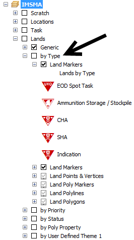
As example Land by Type will be used.
IMSMA layer Land - by Type
- Double-click on the symbol that you would like to change.
- The following window displays
Marker properties
| |||||||||||||

