| |
The Measure Distance functionality is available only if you are using a projected coordinate system. The functionality is disabled if the coordinate system you are using is unknown or geographic. See Change the Map Projection for more details. |
The ![]() button allows you to measure lines, polylines, and polygons on the map. To measure distances on the map:
button allows you to measure lines, polylines, and polygons on the map. To measure distances on the map:
- Click the
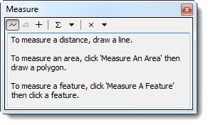
 button to enable the measure distance control. The Measure window displays.
Measure Window
- Click the
 button to measure a line.

The  and
and  buttons are not functional. To measure the perimeter of a polygon, measure each line of the polygon to get the approximate perimeter.
- Click the points of the line or polygon that you would like to measure. To indicate the last point, double-click the last point of the line or polygon. The measurement displays in the Measure window.
