Add Organisation
From IMSMA Wiki
| |
To add an organisation, you must have read and write access to the Organisation permission. |
To add an organisation to IMSMA:
- From the Data Entry menu, select Organisations.
- The Organisation List window displays.
- Click the
 button.
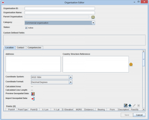
 - The Organisation Editor window displays.
Organisation Editor Window
- Enter the National identifier or other identification number for the organisation in the Organisation ID field.
- Enter the organisation name in the Organisation Name field.
- If the organisation has a parent organisation, click the File:Organisation.jpg button to select the parent organisation.
- Select the organisation type from the Category list.
- If the organisation is active, check the Active checkbox.
- If there are any fields in the Custom Defined Fields section, enter data in those fields.
- Click the Location tab.
- Enter the address of the organisation in the Address field.
- Select the operational area of the organisation:
- Click the button beside the Country Structure Reference field.
- The Country Structure Selection window displays.
- Click the country structure area that is the operational area of the organisation.
- Click the Ok button.
- The name of the country structure that you selected displays in the Country Structure Reference field.
- Select the coordinate reference system that you would like to use from the Coordinate System list.
- Select the coordinate format from the Coordinate Format list.
- There are several options for entering geospatial data. These options and the page on which you can find additional information are listed in the following table.
| Entering Geospatial Data for an Organisation | |
|---|---|
| If you want to… | Refer to… |
| Manually add geospatial points and polygon/polyline points | Manual Geospatial Data Entry. |
| Draw on the map to specify point, polygon, and polyline coordinates | Draw on the Map to Specify Geographic Coordinates. |
| Import geospatial data from excel | Import Geospatial Data from Excel. |
| Import geospatial data from shapefile | Import Geospatial Data from Shapefile. |
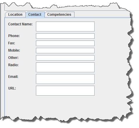
- Click the Contact tab and enter data for the organisation contact:
Organisation Editor – Contact Tab
- Enter the name of the contact in the Contact Name field.
- Enter the phone number for the contact in the Phone field.
- Enter the fax number for the contact in the Fax field.
- Enter the mobile phone number for the contact in the Mobile field.
- Enter any other number for the contact in the Other field.
- Enter the radio number for the contact in the Radio field.
- Enter an e-mail address for the contact in the Email field.
- Enter a URL for the contact in the URL field.
- Click the Competencies tab and enter the competencies data:
- Click the File:UserManual CreateIcon.png button.
- A new row is added to the Competencies table.
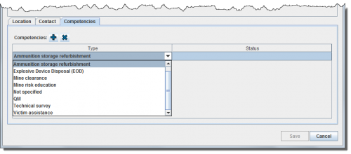
- Click the Type column of the new row that was added.
- A list of competencies displays.
Organisation Editor Selecting a Competency Type
- Select the competency type from the list.
- Click the Status column of the new row that was added.
- Select the status from the list.
- Do one of the following:
- To save the data you have entered for the organisation, click the Save button.
- To discard the organisation data and close the Organisation Editor window, click the Cancel button.
| |||||||||||||||||||||||


