Difference between revisions of "Draw on the Map to Specify Geographic Coordinates"
From IMSMA Wiki
| Line 5: | Line 5: | ||
<li>Click the [[Image:GeoDataIcon.png]] button. | <li>Click the [[Image:GeoDataIcon.png]] button. | ||
:The draw-on map toolbar displays on the IMSMA Navigation window. | :The draw-on map toolbar displays on the IMSMA Navigation window. | ||
| − | [[Image: | + | [[Image:Retrieve 2.png|center|500px|''Draw-On Map Toolbar'']] |
<div align="center"> | <div align="center"> | ||
''Draw-On Map Toolbar'' | ''Draw-On Map Toolbar'' | ||
Revision as of 22:01, 16 January 2015
| |
Before beginning these procedures, you should ensure that the map displayed on the Navigation window is at an extent that allows you to capture the coordinates. |

To specify point and polygon coordinates by drawing on the map:
- Click the
 button.
- The draw-on map toolbar displays on the IMSMA Navigation window.
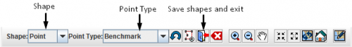
Draw-On Map Toolbar
- Select the type of shape for which you are specifying geospatial information from the Shape list.
- Select the type of point that you are specifying from the Point Type list.
- If you need to manipulate the map on the IMSMA Navigation window before you can capture the coordinates, change the map extent as needed.

| |
You may need to click the |
- Click the point(s) on the map for which you would like to capture the coordinates.
| |
If you click on the same point more than once, no distance and bearing between the points with identical coordinates will be displayed in the Polygons table. |
- Repeat steps 3–6 for each point, polygon, or polyline that you would like to enter into the Data Entry Form.
- Do one of the following:
- If you would like to save the geospatial data, click the
 button.
 - The draw-on map toolbar closes and the coordinates of the selected points are listed in the Points window or Polygon and Polyline Points window.
| |
To preview the points or polygon that you entered, click the |
- If you would like to exit the draw-on map toolbar without saving any changes, click the
 button.
- If you would like to exit the draw-on map toolbar without saving any changes, click the