|
|
| (48 intermediate revisions by 6 users not shown) |
| Line 1: |
Line 1: |
| − | {{Reference guide header|IMSMA themes include items and other data (hospitals, schools, organisations, etc.). Themes that have been recorded ''with geographic coordinates'' (reference points, polygons, lines, etc.) can be ''displayed'' on the map. Displayed items are ''represented'' on the map by ''standard mine action cartographic symbols''. Other data displayed on the map is represented by ''commonly used symbols'' for hospitals, schools, organisations, etc.. | + | {{HowTo's |
| | + | |[[Display the Map Layout Shapes Toolbar|Display the Map Layout Shapes Toolbar]] |
| | + | |[[Add a Legend to the Map Page Layout]] |
| | + | |[[Apply a Template to the Map Page Layout]] |
| | + | }} |
| | + | The Map Pane itself has many functions with are described '''[[Map Pane | here]]''' and how to print out only the content of the Map pane is described [[Print Map Pane and Data| here]]. This part of the wiki covers how to create Map layout/templates which are mainly for printing the map. |
| | | | |
| − | ''Layouts'' help print a map with ''predefined elements'', such as a ''legend'', a ''north indicator'' and a ''scale'' and/or ''drawing elements'' that are helpful for an appropriate understanding of the information displayed on the map. Saved layouts can be ''opened again''. New map layouts can be ''created'' through the ''map layout edit mode tools''.
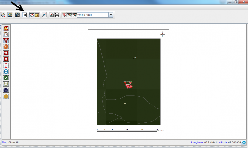
| + | Map layout/template makes it possible to print a map with predefined elements, such as a legend, a north indicator and a scale and/or drawing elements that are helpful for an appropriate understanding of the information displayed on the map. Saved layouts may be re-used and shared between users. |
| | | | |
| − | The ''map menu'' and the ''map toolbar'' offer basic functions that enable you to retrieve additional information from what is displayed on the map.
| + | [[Image:Map template.png|800px|center]] |
| − | }}
| |
| | | | |
| − | __FORCETOC__
| + | {{Note | In ArcGIS 10.1 map layout/template is included in '''mxd''' file and ''mxt'' files do not exist anymore.}} |
| − | {{TOC right}} | |
| | | | |
| − | {{HowTo's | + | {{NavBox Working with IMSMA}} |
| − | |[[HowTo:Open a Saved Map Layout|Open a Saved Map Layout]]
| |
| − | |[[HowTo:Create a Map Layout|Create a Map Layout]]
| |
| − | |[[HowTo:Print the Map Layout|Print the Map Layout]]
| |
| − | |[[HowTo:Save a Newly Created Map Layout|Save a Newly Created Map Layout]]
| |
| − | |[[HowTo:Print the Map without Layout|Print the Map without Layout]]
| |
| − | |[[HowTo:Print Map and Data|Print Map and Data]]
| |
| − | }} | |
| | | | |
| − | <table cellspacing="5" cellpadding="0" style="float: right; clear: right; color: black; background: #f9f9f9; border: 1px solid #aaa; width: 22em; margin: 0 0 1.0em 1.0em; padding: 0.2em; border-spacing: 0.4em 0; text-align: center; line-height: 1.4em; font-size: 88%; background-color: #f5faff; font-size: 90%; width: auto; line-height: 1.6em; width:150px;;;" class="vertical-navbox nowraplinks">
| + | [[Category:CRI]] |
| − | <th style="padding-top: 0.2em 0.4em 0.2em; font-size: 145%; line-height: 1.2em; font-weight: bold; background-color: #9aa8b5; font-size: 125%" class="">Related Topics</th>
| |
| − | <tr>
| |
| − | <td style="padding-top: 0.2em; font-weight: bold; background-color: #cee0f2" class="">Working with the Map in IMSMA<sup>NG</sup></td>
| |
| − | </tr>
| |
| − | <tr>
| |
| − | <td style="padding-bottom: 0.2em; text-align: left">
| |
| − | [[Opening a Saved Layout]]<br />
| |
| − | [[Creating the Layout for the Map]]<br />
| |
| − | [[Predefined Elements]]<br />
| |
| − | [[Drawing Elements]]<br />
| |
| − | [[Map Layout]]<br /> | |
| − | </td>
| |
| − | </tr>
| |
| − | <tr>
| |
| − | <td style="padding-top: 0.2em; font-weight: bold; background-color: #cee0f2" class="">Quick Reference Guide Topics</td>
| |
| − | </tr>
| |
| − | <tr>
| |
| − | <td style="padding-top: 0.2em; text-align: left">
| |
| − | [[Creating a User Guide for IMSMA]]<br />
| |
| − | [[Entering Data into IMSMA]]<br />
| |
| − | [[Impact Scoring in IMSMA]]<br />
| |
| − | [[Producing Reports Using IMSMA]]<br />
| |
| − | </td>
| |
| − | </tr>
| |
| − | </table>
| |
Map layout/template makes it possible to print a map with predefined elements, such as a legend, a north indicator and a scale and/or drawing elements that are helpful for an appropriate understanding of the information displayed on the map. Saved layouts may be re-used and shared between users.
