Difference between revisions of "Coordinate system"
From IMSMA Wiki
| Line 7: | Line 7: | ||
* latitude/longitude | * latitude/longitude | ||
* the coordinate system and format the user used when entering the data. | * the coordinate system and format the user used when entering the data. | ||
| + | |||
| + | The two different formats are shown in the columns ''X / Lon & Y / Lat'' and ''X / Longitude & Y / Latitude'' in the geospatial widgets used in [[Summary Window#Data area - Geospatial tab|Summary windows]] and Data Entry Forms. | ||
Using the Coordinate System manager in the Customisation menu, the administrator controls which coordinate systems could be used for data entry and visualisation in the Map pane. WGS 1984 and MGRS are active after the installation. | Using the Coordinate System manager in the Customisation menu, the administrator controls which coordinate systems could be used for data entry and visualisation in the Map pane. WGS 1984 and MGRS are active after the installation. | ||
Revision as of 16:36, 20 September 2016
| How To |
|---|
All geospatial data in IMSMANG is stored in two different formats:
- latitude/longitude
- the coordinate system and format the user used when entering the data.
The two different formats are shown in the columns X / Lon & Y / Lat and X / Longitude & Y / Latitude in the geospatial widgets used in Summary windows and Data Entry Forms.
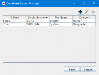
Using the Coordinate System manager in the Customisation menu, the administrator controls which coordinate systems could be used for data entry and visualisation in the Map pane. WGS 1984 and MGRS are active after the installation.
Coordinate System Manager Window
Coordinate systems and formats are used for four different functions in IMSMANG:
- limit which coordinate systems/formats are allowed for data entry
- re-project the map on the fly
- show coordinates of cursor position
- go to coordinates / drop pin in the map
| |||||||||||||
