|
|
| Line 23: |
Line 23: |
| | |} | | |} |
| | |} | | |} |
| − | ==Ordnance Classification==__NOEDITSECTION__
| + | |
| − | {|
| |
| − | |- valign="top"
| |
| − | |
| |
| − | {| class="wikitable"
| |
| − | ! Code
| |
| − | ! Evidence
| |
| − | ! Information
| |
| − | ! Source
| |
| − | |-
| |
| − | | M1
| |
| − | | Mines or UXO physically verified
| |
| − | | Confirmed
| |
| − | | Reliable
| |
| − | |-
| |
| − | | M2
| |
| − | | Area reported with observed evidence of mines or UXO
| |
| − | | Unconfirmed
| |
| − | | Reliable
| |
| − | |-
| |
| − | | M3
| |
| − | | Area reported with observed evidence of mines or UXO
| |
| − | | Unconfirmed
| |
| − | | Unreliable
| |
| − | |-
| |
| − | | M4
| |
| − | | Area reported as mined with no evidence of mines or UXO
| |
| − | | Unconfirmed
| |
| − | | Unreliable
| |
| − | |}
| |
| − | |
| |
| − | {| class="wikitable"
| |
| − | ! colspan="4" | Exists in
| |
| − | |-
| |
| − | | width="100pt"| [[Land Summary Window | Land ]]
| |
| − | |}
| |
| − | |}
| |
| | ==Reliability of Information==__NOEDITSECTION__ | | ==Reliability of Information==__NOEDITSECTION__ |
| | {| | | {| |
Revision as of 15:55, 26 May 2014
The IMSMANG data model contains several fields that may be used for classification of the information.
Confirmed
| Standard values
|
| Yes
|
No
|
Unknown
|
Not Specified
|
|
|
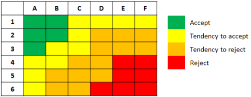
Reliability of Information
| Standard values
|
| 1
|
2
|
3
|
4
|
5
|
6
|
|
|
Reliability of Source
| Standard values
|
| A
|
B
|
C
|
D
|
E
|
F
|
|
|
How to interpret Reliability of Information and Source
| Information
|
Source
|
| 1 - Confirmed
|
A - Reliable
|
| 2 - Possible
|
B - In general reliable
|
| 3 - Less Possible
|
C - Sufficiently reliable
|
| 4 - Doubtable
|
D - Not always reliable
|
| 5 - Improbable
|
E - Less reliable
|
| 6 - Not to be evaluated
|
F - Reliability not valuable
|
|
|
