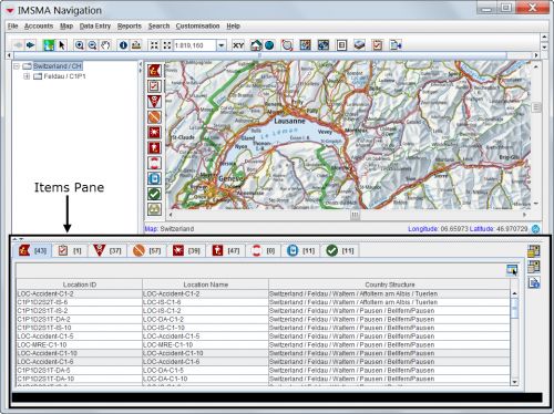
Items Pane
Items Pane
The Items pane of the IMSMA Navigation Window consists of tabs that display the different approved items and a toolbar to the right. These buttons interact with the map. The number displayed in brackets on each item tab is the number of items in the selected Country structure.
| |
The items that are not approved yet are not displayed in the Items pane but can be found in the Workbench |
There are three different types of items in the Item pane:
- Location
 is a special case of item since it has the link to the Country structure and contains items tabs itself
 - Task
 which is its own type since it is neither an Auxiliary data nor an item
 - the other items:
| Functions in the Items Pane | |
| If you do this… | This will happen… |
| Select an item row | If geospatial data exists for the item, a blue circle displays on the map to show the geospatial position. |
| Double-click on item row | The Summary window opens. |
| Double-click on a Task row | The Task editor opens. |
Customising which columns are displayed
IMSMANG allows users to customise the columns that are displayed in the item pane (and list windows). Users can choose from all data elements for each item as well as several of the Location data element set. What columns each user has chosen is stored in the database.
How the Item pane interacts with the Country structure pane
Expand the Country structure tree by clicking on ![]() until you see the node that you are interested in and then click on the Country structure name. Clicking the name of a Country structure will trigger the items panes to be refreshed which may take time if there are many items.
until you see the node that you are interested in and then click on the Country structure name. Clicking the name of a Country structure will trigger the items panes to be refreshed which may take time if there are many items.
Displaying items on the map
To display an item's geospatial data on the map:
- Ensure that the theme for the item that you would like to display on the map is enabled.
- Ensure that you have activated Show selected function in the Item pane toolbar.
- Click the item row that you would like to display on the map.
| |
Rows with a gray background indicate that the item does not have geospatial data associated with it. |
The map displays the item's geospatial data. An additional point is displayed to represent the centroid. Note that it may take a few seconds to update the map.
| |
Double-clicking on an icon in the map is another way of opening the Summary Window for an item. |
