Difference between revisions of "Country Structure Pane"

From IMSMA Wiki
Jump to: navigation, search
 
(25 intermediate revisions by 5 users not shown)
Line 1: Line 1:
<table cellspacing="5" cellpadding="0" style="float: right; clear: right; color: black; background: #f9f9f9; border: 1px solid #aaa; width: 22em; margin: 0 0 1.0em 1.0em; padding: 0.2em; border-spacing: 0.4em 0; text-align: center; line-height: 1.4em; font-size: 88%; background-color: #f5faff; font-size: 90%; width: auto; line-height: 1.6em; width:150px;;;" class="vertical-navbox nowraplinks">
+
The Country Structure pane lists the Country Structure in {{IMSMANG}}. After you log in, the first- and second-level Country Structures display in the Country Structure pane. You can select a Country Structure area from the tree structure to display in the [[Items Pane | items pane]] and in the [[Map Pane | map pane]].
<th style="padding: 0.2em 0.4em 0.2em; font-size: 145%; line-height: 1.2em; font-weight: bold; background-color: #9aa8b5; font-size: 125%" class="">Related Topics</th>
 
<tr>
 
<td style="padding-top: 0.2em; font-weight: bold; background-color: #cee0f2" class="">Daily Activities</td>
 
</tr>
 
<tr>
 
<td style="padding-bottom: 0.2em; text-align: left">
 
[[IMSMA Navigation Window  | IMSMA Navigation]]<br />
 
[[Theme Manager Window | Theme Manager]]<br />
 
[[Current View Windows | Current View]]<br />
 
[[Field Reports | Field Reports]]<br />
 
[[Geospatial Data | Geospatial Data]]<br />
 
</td>
 
</tr>
 
<tr>
 
<td style="padding-top: 0.2em; font-weight: bold; background-color: #cee0f2" class="">IMSMA Navigation</td>
 
</tr>
 
<tr>
 
<td style="padding-bottom: 0.2em; text-align: left">
 
[[Menu Toolbar | Menu Toolbar]]<br />
 
[[Country Structure Pane | Country Structure Pane]]<br />
 
[[Map Pane | Map Pane]]<br />
 
[[Info Pane | Info Pane]]<br />
 
</td>
 
</tr>
 
</table>
 
  
The country structure pane lists the local country structure areas. After you log in, the first- and second-level country structures display in the country structure pane. You can select a country structure area from the list to display on the map and in the items tabs.
+
[[Image:CountryStructurePane.png|center|500px|''Country Structure Pane'']]
 
 
[[Image:fig11.png|center|500px|''Figure 11. Country Structure Pane'']]
 
 
<div align="center">
 
<div align="center">
''Figure 11. Country Structure Pane''
+
''Country Structure Pane''
 
</div>
 
</div>
  
If a country structure area contains country structure areas within it, the [[Image:PlusIcon.png|Plus Icon]] icon displays to the left of the country structure name. The [[Image:PlusIcon.png|Plus Icon]] icon indicates that lower-level country structure areas are hidden from view in the country structure pane. The [[Image:MinusIcon.png|Minus Icon]] icon indicates that the lower-level country structure areas are displayed.
+
If a Country Structure node contains nodes within it,  
 +
* the [[Image:PlusIcon.png|Plus Icon]] displays to the left of the Country Structure name  
 +
* the [[Image:PlusIcon.png|Plus Icon]] indicates that lower-level Country Structure nodes are hidden from view in the Country Structure pane  
 +
* the [[Image:MinusIcon.png|Minus Icon]] indicates that the lower-level Country Structure nodes are displayed.
 +
 
 
<!-- unsure of how to tab over as &nbsp doesn't work -->
 
<!-- unsure of how to tab over as &nbsp doesn't work -->
Table 10 lists the actions that can be taken on the IMSMA Navigation window’s country structure tree.
+
The following table lists the actions that can be taken on the IMSMA Navigation window’s Country Structure tree.
  
{| class="wikitable" width="600"
+
{| class="wikitable" width="900"
 
|-
 
|-
| align="center" colspan="2" | '''Table 10. Allowed Actions on the Country Structure Tree'''
+
| align="center" colspan="2" | '''Allowed Actions on the Country Structure Tree'''
 
|-
 
|-
| width="125pt" | '''If you do this…'''
+
| width="200pt" | '''If you do this…'''
| width="475pt" | '''This will happen…'''
+
| width="700pt" | '''This will happen…'''
 
|-
 
|-
| Click the [[Image:PlusIcon.png|Plus Icon]] icon || Opens the selected country structure area to display the country structure areas contained within it. The icon will change to [[Image:MinusIcon.png|Minus Icon]] after the country structure areas are displayed.
+
| Click on the [[Image:PlusIcon.png|Plus Icon]] || Expands the selected Country Structure node to display the Country Structure nodes contained within it. <br/>The symbol will change to [[Image:MinusIcon.png|Minus Icon]] after the Country Structure nodes are displayed.
 
|-
 
|-
| Click the [[Image:MinusIcon.png|Minus Icon]] icon || Closes the selected country structure area and hides the country structure areas contained within it. The icon will change to [[Image:PlusIcon.png|Plus Icon]] after the country structure areas are hidden.  
+
| Click on the [[Image:MinusIcon.png|Minus Icon]] || Closes the selected Country Structure node and hides the Country Structure nodes contained within it. <br/>The symbol will change to [[Image:PlusIcon.png|Plus Icon]] after the Country Structure nodes are hidden.  
 
|-
 
|-
| Click a country structure area name || The tabs in the items pane display the number of item records in the selected country structure area and country structure areas within it. A table within each tab displays records for the item. The location tab is in front.
+
| Select a Country Structure || The tabs in the items pane display the number of item records in the selected Country Structure. <br/>If the map extent is set for the selected area the map will be centered on the selected Country Structure area.
 
|}
 
|}
  
{| style="border:2px solid lightgray; float:center; margin:10px 10px 10px 14%;"
+
{{note| After updates to the Country Structure is made, it may take a few minutes to refresh the Country Structure pane if the Country Structure is large. }}
|style="padding: 5px 10px 5px 10px"|[[Image:bulb2.png|25px|Represents a tip or note for using IMSMA Mobile.]]
 
|align="left" style="padding: 5px 10px 5px 10px"| After updates to the country structure areas are made, it may take a few minutes to refresh the country structure pane if the country structure is large.  
 
|}


===How to expand a country structure area node===
 
To display the lower-level country structure areas within a country structure area, click the [[Image:PlusIcon.png|Plus Icon]] icon.


===How to collapse a country structure area node===
 
To hide lower-level country structure areas within a country structure area, click the [[Image:MinusIcon.png|Minus Icon]] icon.
 
  
===How to display records for a country structure area===
+
{{NavBox HowTo Viewing and Browsing}}
To display records for a country structure area:
 
  
To display records for a country structure area:
+
[[Category:NAA]]
#Expand the country structure tree to locate the country structure area for which you would like to view records.
 
#Click the name of the country structure in the country structure tree.
 
The tabs in the items pane are updated to reflect data for the selected country structure area and country structure areas within it. For more information, see the Items pane section on page 30.
 
When you click on a country structure area in the country structure tree, the map can also be updated. If a map extent has been specified for the country structure area, the map displays map extent. If a map extent is not available for the country structure, the map display centres on the point designated as point number 1. If no point is available for the country structure area, the map does not change.
 

Latest revision as of 08:07, 18 March 2019

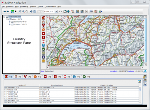
The Country Structure pane lists the Country Structure in IMSMANG. After you log in, the first- and second-level Country Structures display in the Country Structure pane. You can select a Country Structure area from the tree structure to display in the items pane and in the map pane.

Country Structure Pane

Country Structure Pane

If a Country Structure node contains nodes within it,

  • the Plus Icon displays to the left of the Country Structure name
  • the Plus Icon indicates that lower-level Country Structure nodes are hidden from view in the Country Structure pane
  • the Minus Icon indicates that the lower-level Country Structure nodes are displayed.

The following table lists the actions that can be taken on the IMSMA Navigation window’s Country Structure tree.

Allowed Actions on the Country Structure Tree
If you do this… This will happen…
Click on the Plus Icon Expands the selected Country Structure node to display the Country Structure nodes contained within it.
The symbol will change to Minus Icon after the Country Structure nodes are displayed.
Click on the Minus Icon Closes the selected Country Structure node and hides the Country Structure nodes contained within it.
The symbol will change to Plus Icon after the Country Structure nodes are hidden.
Select a Country Structure The tabs in the items pane display the number of item records in the selected Country Structure.
If the map extent is set for the selected area the map will be centered on the selected Country Structure area.
Note.jpg After updates to the Country Structure is made, it may take a few minutes to refresh the Country Structure pane if the Country Structure is large.