Draw on the Map to Specify Geographic Coordinates
| Drawing on the map requires that the background map is of enough good quality to be used for capturing points/polygons for Mine Action. Geographic coordinates that are drawn on the map will use the coordinate system and format that is specified in the Point and Polygon/Polyline List window even if the map is projected to another coordinate system and/or format. |
- Click the
 button.
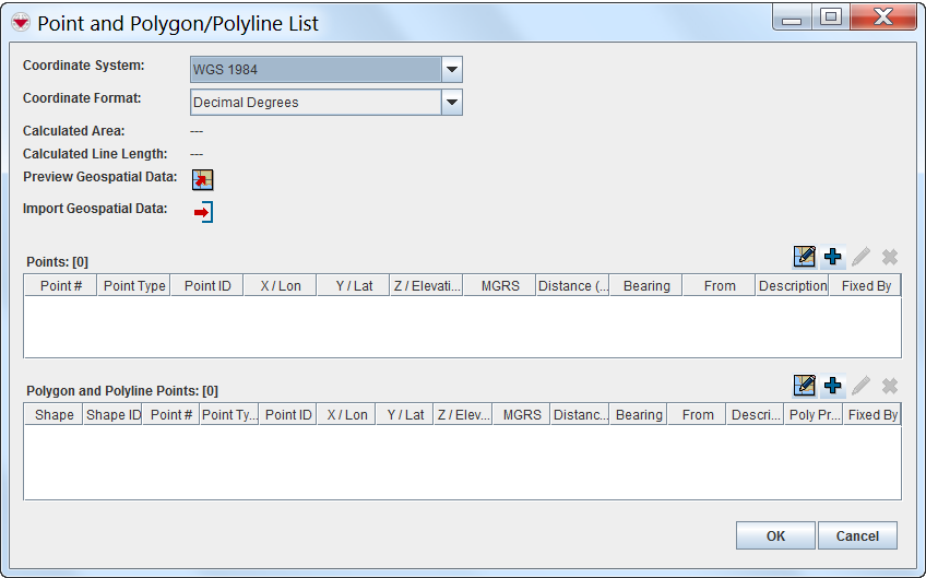
- The draw-on map toolbar displays on the IMSMA Navigation window.
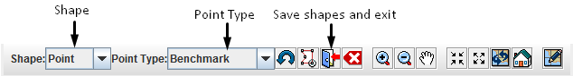
Draw-On Map Toolbar Draw-On Map Toolbar
- Select the type of shape for which you are specifying geospatial information from the Shape list.
- Select the type of point that you are specifying from the Point Type list.
- If you need to manipulate the map on the IMSMA Navigation window before you can capture the coordinates, change the map extent as needed.

You may need to click the button in the toolbar of the IMSMA Navigation window after using the map controls.
- Click the point(s) on the map for which you would like to capture the coordinates.
If you click on the same point more than once, no distance and bearing between the points with identical coordinates will be displayed in the Polygons table. - Repeat steps 3–6 for each point, polygon, or polyline that you would like to enter into the Data Entry Form.
- When you are done, click the
 button. The draw-on map toolbar closes and the coordinates of the selected points are listed in the Points window or Polygon and Polyline Points window.


If you would like to exit the draw-on map function without saving any changes, click the ![]() button.
button.
{{#switch:|subgroup|child=|none=|#default=
{{#if:|<th scope="col" style="border-left:2px solid #fdfdfd;width:100%;|}}{{#if:|{{#if:Using IMSMANG|}}}}{{#if:{{#switch:{{#if:|{{{border}}}|child}}|subgroup|child=|none=|#default=| }}<table cellspacing="0" class="nowraplinks hlist {{#if:Using IMSMANG|{{#switch:autocollapse|plain|off=|#default=collapsible {{#if:autocollapse|autocollapse|autocollapse}}}}}} {{#switch:|subgroup|child|none=navbox-subgroup" style="border-spacing:0;;|#default=navbox-inner" style="border-spacing:0;background:transparent;color:inherit}};;">{{#if:Using IMSMANG| | |
{{{above}}} |
}}{{#if:|{{#if:|<th scope="col" style="border-left:2px solid #fdfdfd;width:100%;|}}{{#if:|{{#if:|}}}}{{#if:Add a Data Entry Form · Use the Data Entry Form Editor Window · Manage Data Entry Form Attachments · Required Fields in Data Entry Forms · Save Data Entry Forms|{{#if:|}}{{#if:|<td class="navbox-image " style="width:0%;padding:0px 2px 0px 0px;" rowspan={{#expr:1{{#if:{{#switch:{{#if:|{{{border}}}|child}}|subgroup|child=|none=|#default=
|doc
|sandbox
|testcases =
|#default = {{#switch:
 |plainlist
 |hlist
 |hlist hnum
 |hlist vcard
 |vcard hlist =
 |#default =
 }}
}}
}}}}}}|+2}}{{#if:|+2}}{{#if:|+2}}{{#if:|+2}}{{#if:|+2}}{{#if:|+2}}{{#if:|+2}}{{#if:|+2}}{{#if:|+2}}{{#if:|+2}}{{#if:|+2}}{{#if:|+2}}{{#if:|+2}}{{#if:|+2}}{{#if:|+2}}{{#if:|+2}}{{#if:|+2}}{{#if:|+2}}{{#if:|+2}}}}> | {{#if:Data Entry Forms|}} | ||||||||||||||||||||||||||||||||||||||||||||||||||||||||||||||||||||||||||||||||||||||||||||||||
|---|---|---|---|---|---|---|---|---|---|---|---|---|---|---|---|---|---|---|---|---|---|---|---|---|---|---|---|---|---|---|---|---|---|---|---|---|---|---|---|---|---|---|---|---|---|---|---|---|---|---|---|---|---|---|---|---|---|---|---|---|---|---|---|---|---|---|---|---|---|---|---|---|---|---|---|---|---|---|---|---|---|---|---|---|---|---|---|---|---|---|---|---|---|---|---|---|---|
| }}{{#if:|{{#if:|<th scope="col" style="border-left:2px solid #fdfdfd;width:100%;|}}{{#if:|{{#if:|}}}}{{#if:Using the ID Generator · Enter Date Information in the Data Entry Form · Enter Text or Numeric Information in the Data Entry Form · Using Option Lists in the Data Entry Form|{{#if:|}}{{#if:|}}{{#if:{{#if:Common Data|}}|<td style="text-align:left;border-left-width:2px;border-left-style:solid;|{{#if:|}}}}{{#if:Enter Cause Data in the Data Entry Form · Enter Country Structure Data in the Data Entry Form · Enter Given Assistance Data in the Data Entry Form · Enter Needs Assessment Data in the Data Entry Form · Enter Ordnance Data in the Data Entry Form · Enter Organisation Data in the Data Entry Form · Enter Place Data in the Data Entry Form|{{#if:Using the ID Generator · Enter Date Information in the Data Entry Form · Enter Text or Numeric Information in the Data Entry Form · Using Option Lists in the Data Entry Form|}}{{#if:{{#if: Auxiliary Data|}}|<td style="text-align:left;border-left-width:2px;border-left-style:solid;|}}{{#if:Point Types · Manual Geospatial Data Entry · Draw on the Map to Specify Geographic Coordinates · Import Geospatial Data from Excel · Import Geospatial Data from Shapefile|{{#if:Using the ID Generator · Enter Date Information in the Data Entry Form · Enter Text or Numeric Information in the Data Entry Form · Using Option Lists in the Data Entry FormEnter Cause Data in the Data Entry Form · Enter Country Structure Data in the Data Entry Form · Enter Given Assistance Data in the Data Entry Form · Enter Needs Assessment Data in the Data Entry Form · Enter Ordnance Data in the Data Entry Form · Enter Organisation Data in the Data Entry Form · Enter Place Data in the Data Entry Form|}}{{#if:{{#if: Geographical Data|}}|<td style="text-align:left;border-left-width:2px;border-left-style:solid;|}}{{#if:|{{#if:{{#if:| {{{group4}}} }}|<td style="text-align:left;border-left-width:2px;border-left-style:solid;|}}{{#if:|{{#if:{{#if:|{{{group5}}} }}|<td style="text-align:left;border-left-width:2px;border-left-style:solid;|}}{{#if:|{{#if:{{#if:|{{{group6}}} }}|<td style="text-align:left;border-left-width:2px;border-left-style:solid;|}}{{#if:|{{#if:{{#if:|{{{group7}}} }}|<td style="text-align:left;border-left-width:2px;border-left-style:solid;|}}{{#if:|{{#if:{{#if:|{{{group8}}} }}|<td style="text-align:left;border-left-width:2px;border-left-style:solid;|}}{{#if:|{{#if:{{#if:|{{{group9}}} }}|<td style="text-align:left;border-left-width:2px;border-left-style:solid;|}}{{#if:|{{#if:{{#if:|{{{group10}}} }}|<td style="text-align:left;border-left-width:2px;border-left-style:solid;|}}{{#if:|{{#if:{{#if:|{{{group11}}} }}|<td style="text-align:left;border-left-width:2px;border-left-style:solid;|}}{{#if:|{{#if:{{#if:|{{{group12}}} }}|<td style="text-align:left;border-left-width:2px;border-left-style:solid;|}}{{#if:|{{#if:{{#if:|{{{group13}}} }}|<td style="text-align:left;border-left-width:2px;border-left-style:solid;|}}{{#if:|{{#if:{{#if:|{{{group14}}} }}|<td style="text-align:left;border-left-width:2px;border-left-style:solid;|}}{{#if:|{{#if:{{#if:|{{{group15}}} }}|<td style="text-align:left;border-left-width:2px;border-left-style:solid;|}}{{#if:|{{#if:{{#if:|{{{group16}}} }}|<td style="text-align:left;border-left-width:2px;border-left-style:solid;|}}{{#if:|{{#if:{{#if:|{{{group17}}} }}|<td style="text-align:left;border-left-width:2px;border-left-style:solid;|}}{{#if:|{{#if:{{#if:|{{{group18}}} }}|<td style="text-align:left;border-left-width:2px;border-left-style:solid;|}}{{#if:|{{#if:{{#if:|{{{group19}}} }}|<td style="text-align:left;border-left-width:2px;border-left-style:solid;|}}{{#if:|{{#if:{{#if:|{{{group20}}} }}|<td style="text-align:left;border-left-width:2px;border-left-style:solid;|}}{{#if:|{{#if:Using the ID Generator · Enter Date Information in the Data Entry Form · Enter Text or Numeric Information in the Data Entry Form · Using Option Lists in the Data Entry FormEnter Cause Data in the Data Entry Form · Enter Country Structure Data in the Data Entry Form · Enter Given Assistance Data in the Data Entry Form · Enter Needs Assessment Data in the Data Entry Form · Enter Ordnance Data in the Data Entry Form · Enter Organisation Data in the Data Entry Form · Enter Place Data in the Data Entry FormPoint Types · Manual Geospatial Data Entry · Draw on the Map to Specify Geographic Coordinates · Import Geospatial Data from Excel · Import Geospatial Data from Shapefile|}}}}
|none=|#default= | ||||||||||||||||||||||||||||||||||||||||||||||||||||||||||||||||||||||||||||||||||||||||
}}{{#ifeq:|Template|{{#ifeq:{{#if:|{{{border}}}|child}}|child||{{#ifeq:{{#if:|{{{border}}}|child}}|subgroup||{{#switch:draw on the map to specify geographic coordinates
|doc
|sandbox
|testcases =
|#default = {{#switch:
 |plainlist
 |hlist
 |hlist hnum
 |hlist vcard
 |vcard hlist =
 |#default =
 }}
}}
}}}}}}|+2}}{{#if:|+2}}{{#if:|+2}}{{#if:|+2}}{{#if:|+2}}{{#if:|+2}}{{#if:|+2}}{{#if:|+2}}{{#if:|+2}}{{#if:|+2}}{{#if:|+2}}{{#if:|+2}}{{#if:|+2}}{{#if:|+2}}{{#if:|+2}}{{#if:|+2}}{{#if:|+2}}{{#if:|+2}}{{#if:|+2}}}}>
}}}}{{#if:{{#switch:{{#if:|{{{border}}}|child}}|subgroup|child=|none=|#default=
| }}{{#if:|{{#if:|<th scope="col" style="border-left:2px solid #fdfdfd;width:100%;|}}{{#if:|{{#if:|}}}}{{#if:Using the ID Generator · Enter Date Information in the Data Entry Form · Enter Text or Numeric Information in the Data Entry Form · Using Option Lists in the Data Entry Form|{{#if:|}}{{#if:|}}{{#if:{{#if:Common Data|}}|<td style="text-align:left;border-left-width:2px;border-left-style:solid;|{{#if:|}}}}{{#if:Enter Cause Data in the Data Entry Form · Enter Country Structure Data in the Data Entry Form · Enter Given Assistance Data in the Data Entry Form · Enter Needs Assessment Data in the Data Entry Form · Enter Ordnance Data in the Data Entry Form · Enter Organisation Data in the Data Entry Form · Enter Place Data in the Data Entry Form|{{#if:Using the ID Generator · Enter Date Information in the Data Entry Form · Enter Text or Numeric Information in the Data Entry Form · Using Option Lists in the Data Entry Form|}}{{#if:{{#if: Auxiliary Data|}}|<td style="text-align:left;border-left-width:2px;border-left-style:solid;|}}{{#if:Point Types · Manual Geospatial Data Entry · Draw on the Map to Specify Geographic Coordinates · Import Geospatial Data from Excel · Import Geospatial Data from Shapefile|{{#if:Using the ID Generator · Enter Date Information in the Data Entry Form · Enter Text or Numeric Information in the Data Entry Form · Using Option Lists in the Data Entry FormEnter Cause Data in the Data Entry Form · Enter Country Structure Data in the Data Entry Form · Enter Given Assistance Data in the Data Entry Form · Enter Needs Assessment Data in the Data Entry Form · Enter Ordnance Data in the Data Entry Form · Enter Organisation Data in the Data Entry Form · Enter Place Data in the Data Entry Form|}}{{#if:{{#if: Geographical Data|}}|<td style="text-align:left;border-left-width:2px;border-left-style:solid;|}}{{#if:|{{#if:{{#if:| {{{group4}}} }}|<td style="text-align:left;border-left-width:2px;border-left-style:solid;|}}{{#if:|{{#if:{{#if:|{{{group5}}} }}|<td style="text-align:left;border-left-width:2px;border-left-style:solid;|}}{{#if:|{{#if:{{#if:|{{{group6}}} }}|<td style="text-align:left;border-left-width:2px;border-left-style:solid;|}}{{#if:|{{#if:{{#if:|{{{group7}}} }}|<td style="text-align:left;border-left-width:2px;border-left-style:solid;|}}{{#if:|{{#if:{{#if:|{{{group8}}} }}|<td style="text-align:left;border-left-width:2px;border-left-style:solid;|}}{{#if:|{{#if:{{#if:|{{{group9}}} }}|<td style="text-align:left;border-left-width:2px;border-left-style:solid;|}}{{#if:|{{#if:{{#if:|{{{group10}}} }}|<td style="text-align:left;border-left-width:2px;border-left-style:solid;|}}{{#if:|{{#if:{{#if:|{{{group11}}} }}|<td style="text-align:left;border-left-width:2px;border-left-style:solid;|}}{{#if:|{{#if:{{#if:|{{{group12}}} }}|<td style="text-align:left;border-left-width:2px;border-left-style:solid;|}}{{#if:|{{#if:{{#if:|{{{group13}}} }}|<td style="text-align:left;border-left-width:2px;border-left-style:solid;|}}{{#if:|{{#if:{{#if:|{{{group14}}} }}|<td style="text-align:left;border-left-width:2px;border-left-style:solid;|}}{{#if:|{{#if:{{#if:|{{{group15}}} }}|<td style="text-align:left;border-left-width:2px;border-left-style:solid;|}}{{#if:|{{#if:{{#if:|{{{group16}}} }}|<td style="text-align:left;border-left-width:2px;border-left-style:solid;|}}{{#if:|{{#if:{{#if:|{{{group17}}} }}|<td style="text-align:left;border-left-width:2px;border-left-style:solid;|}}{{#if:|{{#if:{{#if:|{{{group18}}} }}|<td style="text-align:left;border-left-width:2px;border-left-style:solid;|}}{{#if:|{{#if:{{#if:|{{{group19}}} }}|<td style="text-align:left;border-left-width:2px;border-left-style:solid;|}}{{#if:|{{#if:{{#if:|{{{group20}}} }}|<td style="text-align:left;border-left-width:2px;border-left-style:solid;|}}{{#if:|{{#if:Using the ID Generator · Enter Date Information in the Data Entry Form · Enter Text or Numeric Information in the Data Entry Form · Using Option Lists in the Data Entry FormEnter Cause Data in the Data Entry Form · Enter Country Structure Data in the Data Entry Form · Enter Given Assistance Data in the Data Entry Form · Enter Needs Assessment Data in the Data Entry Form · Enter Ordnance Data in the Data Entry Form · Enter Organisation Data in the Data Entry Form · Enter Place Data in the Data Entry FormPoint Types · Manual Geospatial Data Entry · Draw on the Map to Specify Geographic Coordinates · Import Geospatial Data from Excel · Import Geospatial Data from Shapefile|}}}}
|none=|#default= | ||||||||||||||||||||||||||||||||||||||||||||||||||||||||||||||||||||||||||||||||||||||||
}}{{#ifeq:|Template|{{#ifeq:{{#if:|{{{border}}}|child}}|child||{{#ifeq:{{#if:|{{{border}}}|child}}|subgroup||{{#switch:draw on the map to specify geographic coordinates
|doc
|sandbox
|testcases =
|#default = {{#switch:
 |plainlist
 |hlist
 |hlist hnum
 |hlist vcard
 |vcard hlist =
 |#default =
 }}
}}
}}}}}}|{{#if:Add a Data Entry Form · Use the Data Entry Form Editor Window · Manage Data Entry Form Attachments · Required Fields in Data Entry Forms · Save Data Entry Forms|}}{{#if:{{#if:Data Fields|
}}|{{#if:Data Fields|
}}<td style="text-align:left;border-left-width:2px;border-left-style:solid;|
|none=|#default=
| }}{{#if:|{{#if:|<th scope="col" style="border-left:2px solid #fdfdfd;width:100%;|}}{{#if:|{{#if:|}}}}{{#if:Using the ID Generator · Enter Date Information in the Data Entry Form · Enter Text or Numeric Information in the Data Entry Form · Using Option Lists in the Data Entry Form|{{#if:|}}{{#if:|}}{{#if:{{#if:Common Data|}}|<td style="text-align:left;border-left-width:2px;border-left-style:solid;|{{#if:|}}}}{{#if:Enter Cause Data in the Data Entry Form · Enter Country Structure Data in the Data Entry Form · Enter Given Assistance Data in the Data Entry Form · Enter Needs Assessment Data in the Data Entry Form · Enter Ordnance Data in the Data Entry Form · Enter Organisation Data in the Data Entry Form · Enter Place Data in the Data Entry Form|{{#if:Using the ID Generator · Enter Date Information in the Data Entry Form · Enter Text or Numeric Information in the Data Entry Form · Using Option Lists in the Data Entry Form|}}{{#if:{{#if: Auxiliary Data|}}|<td style="text-align:left;border-left-width:2px;border-left-style:solid;|}}{{#if:Point Types · Manual Geospatial Data Entry · Draw on the Map to Specify Geographic Coordinates · Import Geospatial Data from Excel · Import Geospatial Data from Shapefile|{{#if:Using the ID Generator · Enter Date Information in the Data Entry Form · Enter Text or Numeric Information in the Data Entry Form · Using Option Lists in the Data Entry FormEnter Cause Data in the Data Entry Form · Enter Country Structure Data in the Data Entry Form · Enter Given Assistance Data in the Data Entry Form · Enter Needs Assessment Data in the Data Entry Form · Enter Ordnance Data in the Data Entry Form · Enter Organisation Data in the Data Entry Form · Enter Place Data in the Data Entry Form|}}{{#if:{{#if: Geographical Data|}}|<td style="text-align:left;border-left-width:2px;border-left-style:solid;|}}{{#if:|{{#if:{{#if:| {{{group4}}} }}|<td style="text-align:left;border-left-width:2px;border-left-style:solid;|}}{{#if:|{{#if:{{#if:|{{{group5}}} }}|<td style="text-align:left;border-left-width:2px;border-left-style:solid;|}}{{#if:|{{#if:{{#if:|{{{group6}}} }}|<td style="text-align:left;border-left-width:2px;border-left-style:solid;|}}{{#if:|{{#if:{{#if:|{{{group7}}} }}|<td style="text-align:left;border-left-width:2px;border-left-style:solid;|}}{{#if:|{{#if:{{#if:|{{{group8}}} }}|<td style="text-align:left;border-left-width:2px;border-left-style:solid;|}}{{#if:|{{#if:{{#if:|{{{group9}}} }}|<td style="text-align:left;border-left-width:2px;border-left-style:solid;|}}{{#if:|{{#if:{{#if:|{{{group10}}} }}|<td style="text-align:left;border-left-width:2px;border-left-style:solid;|}}{{#if:|{{#if:{{#if:|{{{group11}}} }}|<td style="text-align:left;border-left-width:2px;border-left-style:solid;|}}{{#if:|{{#if:{{#if:|{{{group12}}} }}|<td style="text-align:left;border-left-width:2px;border-left-style:solid;|}}{{#if:|{{#if:{{#if:|{{{group13}}} }}|<td style="text-align:left;border-left-width:2px;border-left-style:solid;|}}{{#if:|{{#if:{{#if:|{{{group14}}} }}|<td style="text-align:left;border-left-width:2px;border-left-style:solid;|}}{{#if:|{{#if:{{#if:|{{{group15}}} }}|<td style="text-align:left;border-left-width:2px;border-left-style:solid;|}}{{#if:|{{#if:{{#if:|{{{group16}}} }}|<td style="text-align:left;border-left-width:2px;border-left-style:solid;|}}{{#if:|{{#if:{{#if:|{{{group17}}} }}|<td style="text-align:left;border-left-width:2px;border-left-style:solid;|}}{{#if:|{{#if:{{#if:|{{{group18}}} }}|<td style="text-align:left;border-left-width:2px;border-left-style:solid;|}}{{#if:|{{#if:{{#if:|{{{group19}}} }}|<td style="text-align:left;border-left-width:2px;border-left-style:solid;|}}{{#if:|{{#if:{{#if:|{{{group20}}} }}|<td style="text-align:left;border-left-width:2px;border-left-style:solid;|}}{{#if:|{{#if:Using the ID Generator · Enter Date Information in the Data Entry Form · Enter Text or Numeric Information in the Data Entry Form · Using Option Lists in the Data Entry FormEnter Cause Data in the Data Entry Form · Enter Country Structure Data in the Data Entry Form · Enter Given Assistance Data in the Data Entry Form · Enter Needs Assessment Data in the Data Entry Form · Enter Ordnance Data in the Data Entry Form · Enter Organisation Data in the Data Entry Form · Enter Place Data in the Data Entry FormPoint Types · Manual Geospatial Data Entry · Draw on the Map to Specify Geographic Coordinates · Import Geospatial Data from Excel · Import Geospatial Data from Shapefile|}}}}
|none=|#default= | ||||||||||||||||||||||||||||||||||||||||||||||||||||||||||||||||||||||||||||||||||||||||
}}{{#ifeq:|Template|{{#ifeq:{{#if:|{{{border}}}|child}}|child||{{#ifeq:{{#if:|{{{border}}}|child}}|subgroup||{{#switch:draw on the map to specify geographic coordinates
|doc
|sandbox
|testcases =
|#default = {{#switch:
 |plainlist
 |hlist
 |hlist hnum
 |hlist vcard
 |vcard hlist =
 |#default =
 }}
}}
}}}}}}}}{{#if:|{{#if:Add a Data Entry Form · Use the Data Entry Form Editor Window · Manage Data Entry Form Attachments · Required Fields in Data Entry Forms · Save Data Entry Forms{{#switch:{{#if:|{{{border}}}|child}}|subgroup|child=|none=|#default=
| }}{{#if:|{{#if:|<th scope="col" style="border-left:2px solid #fdfdfd;width:100%;|}}{{#if:|{{#if:|}}}}{{#if:Using the ID Generator · Enter Date Information in the Data Entry Form · Enter Text or Numeric Information in the Data Entry Form · Using Option Lists in the Data Entry Form|{{#if:|}}{{#if:|}}{{#if:{{#if:Common Data|}}|<td style="text-align:left;border-left-width:2px;border-left-style:solid;|{{#if:|}}}}{{#if:Enter Cause Data in the Data Entry Form · Enter Country Structure Data in the Data Entry Form · Enter Given Assistance Data in the Data Entry Form · Enter Needs Assessment Data in the Data Entry Form · Enter Ordnance Data in the Data Entry Form · Enter Organisation Data in the Data Entry Form · Enter Place Data in the Data Entry Form|{{#if:Using the ID Generator · Enter Date Information in the Data Entry Form · Enter Text or Numeric Information in the Data Entry Form · Using Option Lists in the Data Entry Form|}}{{#if:{{#if: Auxiliary Data|}}|<td style="text-align:left;border-left-width:2px;border-left-style:solid;|}}{{#if:Point Types · Manual Geospatial Data Entry · Draw on the Map to Specify Geographic Coordinates · Import Geospatial Data from Excel · Import Geospatial Data from Shapefile|{{#if:Using the ID Generator · Enter Date Information in the Data Entry Form · Enter Text or Numeric Information in the Data Entry Form · Using Option Lists in the Data Entry FormEnter Cause Data in the Data Entry Form · Enter Country Structure Data in the Data Entry Form · Enter Given Assistance Data in the Data Entry Form · Enter Needs Assessment Data in the Data Entry Form · Enter Ordnance Data in the Data Entry Form · Enter Organisation Data in the Data Entry Form · Enter Place Data in the Data Entry Form|}}{{#if:{{#if: Geographical Data|}}|<td style="text-align:left;border-left-width:2px;border-left-style:solid;|}}{{#if:|{{#if:{{#if:| {{{group4}}} }}|<td style="text-align:left;border-left-width:2px;border-left-style:solid;|}}{{#if:|{{#if:{{#if:|{{{group5}}} }}|<td style="text-align:left;border-left-width:2px;border-left-style:solid;|}}{{#if:|{{#if:{{#if:|{{{group6}}} }}|<td style="text-align:left;border-left-width:2px;border-left-style:solid;|}}{{#if:|{{#if:{{#if:|{{{group7}}} }}|<td style="text-align:left;border-left-width:2px;border-left-style:solid;|}}{{#if:|{{#if:{{#if:|{{{group8}}} }}|<td style="text-align:left;border-left-width:2px;border-left-style:solid;|}}{{#if:|{{#if:{{#if:|{{{group9}}} }}|<td style="text-align:left;border-left-width:2px;border-left-style:solid;|}}{{#if:|{{#if:{{#if:|{{{group10}}} }}|<td style="text-align:left;border-left-width:2px;border-left-style:solid;|}}{{#if:|{{#if:{{#if:|{{{group11}}} }}|<td style="text-align:left;border-left-width:2px;border-left-style:solid;|}}{{#if:|{{#if:{{#if:|{{{group12}}} }}|<td style="text-align:left;border-left-width:2px;border-left-style:solid;|}}{{#if:|{{#if:{{#if:|{{{group13}}} }}|<td style="text-align:left;border-left-width:2px;border-left-style:solid;|}}{{#if:|{{#if:{{#if:|{{{group14}}} }}|<td style="text-align:left;border-left-width:2px;border-left-style:solid;|}}{{#if:|{{#if:{{#if:|{{{group15}}} }}|<td style="text-align:left;border-left-width:2px;border-left-style:solid;|}}{{#if:|{{#if:{{#if:|{{{group16}}} }}|<td style="text-align:left;border-left-width:2px;border-left-style:solid;|}}{{#if:|{{#if:{{#if:|{{{group17}}} }}|<td style="text-align:left;border-left-width:2px;border-left-style:solid;|}}{{#if:|{{#if:{{#if:|{{{group18}}} }}|<td style="text-align:left;border-left-width:2px;border-left-style:solid;|}}{{#if:|{{#if:{{#if:|{{{group19}}} }}|<td style="text-align:left;border-left-width:2px;border-left-style:solid;|}}{{#if:|{{#if:{{#if:|{{{group20}}} }}|<td style="text-align:left;border-left-width:2px;border-left-style:solid;|}}{{#if:|{{#if:Using the ID Generator · Enter Date Information in the Data Entry Form · Enter Text or Numeric Information in the Data Entry Form · Using Option Lists in the Data Entry FormEnter Cause Data in the Data Entry Form · Enter Country Structure Data in the Data Entry Form · Enter Given Assistance Data in the Data Entry Form · Enter Needs Assessment Data in the Data Entry Form · Enter Ordnance Data in the Data Entry Form · Enter Organisation Data in the Data Entry Form · Enter Place Data in the Data Entry FormPoint Types · Manual Geospatial Data Entry · Draw on the Map to Specify Geographic Coordinates · Import Geospatial Data from Excel · Import Geospatial Data from Shapefile|}}}}
|none=|#default= | ||||||||||||||||||||||||||||||||||||||||||||||||||||||||||||||||||||||||||||||||||||||||
}}{{#ifeq:|Template|{{#ifeq:{{#if:|{{{border}}}|child}}|child||{{#ifeq:{{#if:|{{{border}}}|child}}|subgroup||{{#switch:draw on the map to specify geographic coordinates
|doc
|sandbox
|testcases =
|#default = {{#switch:
 |plainlist
 |hlist
 |hlist hnum
 |hlist vcard
 |vcard hlist =
 |#default =
 }}
}}
}}}}}}|}}{{#if:{{#if:|
}}|{{#if:|
}}<td style="text-align:left;border-left-width:2px;border-left-style:solid;|
}}{{#if:|{{#if:{{#if:|
}}|{{#if:|
}}<td style="text-align:left;border-left-width:2px;border-left-style:solid;|
}}{{#if:|{{#if:{{#if:|
}}|{{#if:|
}}<td style="text-align:left;border-left-width:2px;border-left-style:solid;|
}}{{#if:|{{#if:{{#if:|
}}|{{#if:|
}}<td style="text-align:left;border-left-width:2px;border-left-style:solid;|
}}{{#if:|{{#if:{{#if:|
}}|{{#if:|
}}<td style="text-align:left;border-left-width:2px;border-left-style:solid;|
}}{{#if:|{{#if:{{#if:|
}}|{{#if:|
}}<td style="text-align:left;border-left-width:2px;border-left-style:solid;|
}}{{#if:|{{#if:{{#if:|
}}|{{#if:|
}}<td style="text-align:left;border-left-width:2px;border-left-style:solid;|
}}{{#if:|{{#if:{{#if:|
}}|{{#if:|
}}<td style="text-align:left;border-left-width:2px;border-left-style:solid;|
}}{{#if:|{{#if:{{#if:|
}}|{{#if:|
}}<td style="text-align:left;border-left-width:2px;border-left-style:solid;|
}}{{#if:|{{#if:{{#if:|
}}|{{#if:|
}}<td style="text-align:left;border-left-width:2px;border-left-style:solid;|
}}{{#if:|{{#if:{{#if:|
}}|{{#if:|
}}<td style="text-align:left;border-left-width:2px;border-left-style:solid;|
}}{{#if:|{{#if:{{#if:|
}}|{{#if:|
}}<td style="text-align:left;border-left-width:2px;border-left-style:solid;|
}}{{#if:|{{#if:{{#if:|
}}|{{#if:|
}}<td style="text-align:left;border-left-width:2px;border-left-style:solid;|
}}{{#if:|{{#if:{{#if:|
}}|{{#if:|
}}<td style="text-align:left;border-left-width:2px;border-left-style:solid;|
}}{{#if:|{{#if:{{#if:|
}}|{{#if:|
}}<td style="text-align:left;border-left-width:2px;border-left-style:solid;|
}}{{#if:|{{#if:{{#if:|
}}|{{#if:|
}}<td style="text-align:left;border-left-width:2px;border-left-style:solid;|
}}{{#if:|{{#if:{{#if:|
}}|{{#if:|
}}<td style="text-align:left;border-left-width:2px;border-left-style:solid;|
}}{{#if:|{{#if:{{#if:|
}}|{{#if:|
}}<td style="text-align:left;border-left-width:2px;border-left-style:solid;|
}}{{#if:|{{#if:Add a Data Entry Form · Use the Data Entry Form Editor Window · Manage Data Entry Form Attachments · Required Fields in Data Entry Forms · Save Data Entry Forms{{#switch:{{#if:|{{{border}}}|child}}|subgroup|child=|none=|#default=
| }}{{#if:|{{#if:|<th scope="col" style="border-left:2px solid #fdfdfd;width:100%;|}}{{#if:|{{#if:|}}}}{{#if:Using the ID Generator · Enter Date Information in the Data Entry Form · Enter Text or Numeric Information in the Data Entry Form · Using Option Lists in the Data Entry Form|{{#if:|}}{{#if:|}}{{#if:{{#if:Common Data|}}|<td style="text-align:left;border-left-width:2px;border-left-style:solid;|{{#if:|}}}}{{#if:Enter Cause Data in the Data Entry Form · Enter Country Structure Data in the Data Entry Form · Enter Given Assistance Data in the Data Entry Form · Enter Needs Assessment Data in the Data Entry Form · Enter Ordnance Data in the Data Entry Form · Enter Organisation Data in the Data Entry Form · Enter Place Data in the Data Entry Form|{{#if:Using the ID Generator · Enter Date Information in the Data Entry Form · Enter Text or Numeric Information in the Data Entry Form · Using Option Lists in the Data Entry Form|}}{{#if:{{#if: Auxiliary Data|}}|<td style="text-align:left;border-left-width:2px;border-left-style:solid;|}}{{#if:Point Types · Manual Geospatial Data Entry · Draw on the Map to Specify Geographic Coordinates · Import Geospatial Data from Excel · Import Geospatial Data from Shapefile|{{#if:Using the ID Generator · Enter Date Information in the Data Entry Form · Enter Text or Numeric Information in the Data Entry Form · Using Option Lists in the Data Entry FormEnter Cause Data in the Data Entry Form · Enter Country Structure Data in the Data Entry Form · Enter Given Assistance Data in the Data Entry Form · Enter Needs Assessment Data in the Data Entry Form · Enter Ordnance Data in the Data Entry Form · Enter Organisation Data in the Data Entry Form · Enter Place Data in the Data Entry Form|}}{{#if:{{#if: Geographical Data|}}|<td style="text-align:left;border-left-width:2px;border-left-style:solid;|}}{{#if:|{{#if:{{#if:| {{{group4}}} }}|<td style="text-align:left;border-left-width:2px;border-left-style:solid;|}}{{#if:|{{#if:{{#if:|{{{group5}}} }}|<td style="text-align:left;border-left-width:2px;border-left-style:solid;|}}{{#if:|{{#if:{{#if:|{{{group6}}} }}|<td style="text-align:left;border-left-width:2px;border-left-style:solid;|}}{{#if:|{{#if:{{#if:|{{{group7}}} }}|<td style="text-align:left;border-left-width:2px;border-left-style:solid;|}}{{#if:|{{#if:{{#if:|{{{group8}}} }}|<td style="text-align:left;border-left-width:2px;border-left-style:solid;|}}{{#if:|{{#if:{{#if:|{{{group9}}} }}|<td style="text-align:left;border-left-width:2px;border-left-style:solid;|}}{{#if:|{{#if:{{#if:|{{{group10}}} }}|<td style="text-align:left;border-left-width:2px;border-left-style:solid;|}}{{#if:|{{#if:{{#if:|{{{group11}}} }}|<td style="text-align:left;border-left-width:2px;border-left-style:solid;|}}{{#if:|{{#if:{{#if:|{{{group12}}} }}|<td style="text-align:left;border-left-width:2px;border-left-style:solid;|}}{{#if:|{{#if:{{#if:|{{{group13}}} }}|<td style="text-align:left;border-left-width:2px;border-left-style:solid;|}}{{#if:|{{#if:{{#if:|{{{group14}}} }}|<td style="text-align:left;border-left-width:2px;border-left-style:solid;|}}{{#if:|{{#if:{{#if:|{{{group15}}} }}|<td style="text-align:left;border-left-width:2px;border-left-style:solid;|}}{{#if:|{{#if:{{#if:|{{{group16}}} }}|<td style="text-align:left;border-left-width:2px;border-left-style:solid;|}}{{#if:|{{#if:{{#if:|{{{group17}}} }}|<td style="text-align:left;border-left-width:2px;border-left-style:solid;|}}{{#if:|{{#if:{{#if:|{{{group18}}} }}|<td style="text-align:left;border-left-width:2px;border-left-style:solid;|}}{{#if:|{{#if:{{#if:|{{{group19}}} }}|<td style="text-align:left;border-left-width:2px;border-left-style:solid;|}}{{#if:|{{#if:{{#if:|{{{group20}}} }}|<td style="text-align:left;border-left-width:2px;border-left-style:solid;|}}{{#if:|{{#if:Using the ID Generator · Enter Date Information in the Data Entry Form · Enter Text or Numeric Information in the Data Entry Form · Using Option Lists in the Data Entry FormEnter Cause Data in the Data Entry Form · Enter Country Structure Data in the Data Entry Form · Enter Given Assistance Data in the Data Entry Form · Enter Needs Assessment Data in the Data Entry Form · Enter Ordnance Data in the Data Entry Form · Enter Organisation Data in the Data Entry Form · Enter Place Data in the Data Entry FormPoint Types · Manual Geospatial Data Entry · Draw on the Map to Specify Geographic Coordinates · Import Geospatial Data from Excel · Import Geospatial Data from Shapefile|}}}}
|none=|#default= | ||||||||||||||||||||||||||||||||||||||||||||||||||||||||||||||||||||||||||||||||||||||||
}}{{#ifeq:|Template|{{#ifeq:{{#if:|{{{border}}}|child}}|child||{{#ifeq:{{#if:|{{{border}}}|child}}|subgroup||{{#switch:draw on the map to specify geographic coordinates
|doc
|sandbox
|testcases =
|#default = {{#switch:
 |plainlist
 |hlist
 |hlist hnum
 |hlist vcard
 |vcard hlist =
 |#default =
 }}
}}
}}}}}}|}}
}}{{#switch:{{#if:|{{{border}}}|child}}|subgroup|child=
|doc
|sandbox
|testcases =
|#default = {{#switch:
 |plainlist
 |hlist
 |hlist hnum
 |hlist vcard
 |vcard hlist =
 |#default =
 }}
}}
}}}}}}|{{#if:Using IMSMANG|}}{{#if:|}}{{#if:|{{#if:|<th scope="col" style="border-left:2px solid #fdfdfd;width:100%;|}}{{#if:|{{#if:|}}}}{{#if:Add a Data Entry Form · Use the Data Entry Form Editor Window · Manage Data Entry Form Attachments · Required Fields in Data Entry Forms · Save Data Entry Forms|{{#if:|}}{{#if:|<td class="navbox-image " style="width:0%;padding:0px 2px 0px 0px;" rowspan={{#expr:1{{#if:{{#switch:{{#if:|{{{border}}}|child}}|subgroup|child=|none=|#default=
|doc
|sandbox
|testcases =
|#default = {{#switch:
 |plainlist
 |hlist
 |hlist hnum
 |hlist vcard
 |vcard hlist =
 |#default =
 }}
}}
}}}}}}|+2}}{{#if:|+2}}{{#if:|+2}}{{#if:|+2}}{{#if:|+2}}{{#if:|+2}}{{#if:|+2}}{{#if:|+2}}{{#if:|+2}}{{#if:|+2}}{{#if:|+2}}{{#if:|+2}}{{#if:|+2}}{{#if:|+2}}{{#if:|+2}}{{#if:|+2}}{{#if:|+2}}{{#if:|+2}}{{#if:|+2}}}}> | {{#if:Data Entry Forms|}} | ||||||||||||||||||||||||||||||||||||||||||||||||||||||||||||||||||||||||||||||||||||||||||||||||
|---|---|---|---|---|---|---|---|---|---|---|---|---|---|---|---|---|---|---|---|---|---|---|---|---|---|---|---|---|---|---|---|---|---|---|---|---|---|---|---|---|---|---|---|---|---|---|---|---|---|---|---|---|---|---|---|---|---|---|---|---|---|---|---|---|---|---|---|---|---|---|---|---|---|---|---|---|---|---|---|---|---|---|---|---|---|---|---|---|---|---|---|---|---|---|---|---|---|
| }}{{#if:|{{#if:|<th scope="col" style="border-left:2px solid #fdfdfd;width:100%;|}}{{#if:|{{#if:|}}}}{{#if:Using the ID Generator · Enter Date Information in the Data Entry Form · Enter Text or Numeric Information in the Data Entry Form · Using Option Lists in the Data Entry Form|{{#if:|}}{{#if:|}}{{#if:{{#if:Common Data|}}|<td style="text-align:left;border-left-width:2px;border-left-style:solid;|{{#if:|}}}}{{#if:Enter Cause Data in the Data Entry Form · Enter Country Structure Data in the Data Entry Form · Enter Given Assistance Data in the Data Entry Form · Enter Needs Assessment Data in the Data Entry Form · Enter Ordnance Data in the Data Entry Form · Enter Organisation Data in the Data Entry Form · Enter Place Data in the Data Entry Form|{{#if:Using the ID Generator · Enter Date Information in the Data Entry Form · Enter Text or Numeric Information in the Data Entry Form · Using Option Lists in the Data Entry Form|}}{{#if:{{#if: Auxiliary Data|}}|<td style="text-align:left;border-left-width:2px;border-left-style:solid;|}}{{#if:Point Types · Manual Geospatial Data Entry · Draw on the Map to Specify Geographic Coordinates · Import Geospatial Data from Excel · Import Geospatial Data from Shapefile|{{#if:Using the ID Generator · Enter Date Information in the Data Entry Form · Enter Text or Numeric Information in the Data Entry Form · Using Option Lists in the Data Entry FormEnter Cause Data in the Data Entry Form · Enter Country Structure Data in the Data Entry Form · Enter Given Assistance Data in the Data Entry Form · Enter Needs Assessment Data in the Data Entry Form · Enter Ordnance Data in the Data Entry Form · Enter Organisation Data in the Data Entry Form · Enter Place Data in the Data Entry Form|}}{{#if:{{#if: Geographical Data|}}|<td style="text-align:left;border-left-width:2px;border-left-style:solid;|}}{{#if:|{{#if:{{#if:| {{{group4}}} }}|<td style="text-align:left;border-left-width:2px;border-left-style:solid;|}}{{#if:|{{#if:{{#if:|{{{group5}}} }}|<td style="text-align:left;border-left-width:2px;border-left-style:solid;|}}{{#if:|{{#if:{{#if:|{{{group6}}} }}|<td style="text-align:left;border-left-width:2px;border-left-style:solid;|}}{{#if:|{{#if:{{#if:|{{{group7}}} }}|<td style="text-align:left;border-left-width:2px;border-left-style:solid;|}}{{#if:|{{#if:{{#if:|{{{group8}}} }}|<td style="text-align:left;border-left-width:2px;border-left-style:solid;|}}{{#if:|{{#if:{{#if:|{{{group9}}} }}|<td style="text-align:left;border-left-width:2px;border-left-style:solid;|}}{{#if:|{{#if:{{#if:|{{{group10}}} }}|<td style="text-align:left;border-left-width:2px;border-left-style:solid;|}}{{#if:|{{#if:{{#if:|{{{group11}}} }}|<td style="text-align:left;border-left-width:2px;border-left-style:solid;|}}{{#if:|{{#if:{{#if:|{{{group12}}} }}|<td style="text-align:left;border-left-width:2px;border-left-style:solid;|}}{{#if:|{{#if:{{#if:|{{{group13}}} }}|<td style="text-align:left;border-left-width:2px;border-left-style:solid;|}}{{#if:|{{#if:{{#if:|{{{group14}}} }}|<td style="text-align:left;border-left-width:2px;border-left-style:solid;|}}{{#if:|{{#if:{{#if:|{{{group15}}} }}|<td style="text-align:left;border-left-width:2px;border-left-style:solid;|}}{{#if:|{{#if:{{#if:|{{{group16}}} }}|<td style="text-align:left;border-left-width:2px;border-left-style:solid;|}}{{#if:|{{#if:{{#if:|{{{group17}}} }}|<td style="text-align:left;border-left-width:2px;border-left-style:solid;|}}{{#if:|{{#if:{{#if:|{{{group18}}} }}|<td style="text-align:left;border-left-width:2px;border-left-style:solid;|}}{{#if:|{{#if:{{#if:|{{{group19}}} }}|<td style="text-align:left;border-left-width:2px;border-left-style:solid;|}}{{#if:|{{#if:{{#if:|{{{group20}}} }}|<td style="text-align:left;border-left-width:2px;border-left-style:solid;|}}{{#if:|{{#if:Using the ID Generator · Enter Date Information in the Data Entry Form · Enter Text or Numeric Information in the Data Entry Form · Using Option Lists in the Data Entry FormEnter Cause Data in the Data Entry Form · Enter Country Structure Data in the Data Entry Form · Enter Given Assistance Data in the Data Entry Form · Enter Needs Assessment Data in the Data Entry Form · Enter Ordnance Data in the Data Entry Form · Enter Organisation Data in the Data Entry Form · Enter Place Data in the Data Entry FormPoint Types · Manual Geospatial Data Entry · Draw on the Map to Specify Geographic Coordinates · Import Geospatial Data from Excel · Import Geospatial Data from Shapefile|}}}}
|none=|#default= | ||||||||||||||||||||||||||||||||||||||||||||||||||||||||||||||||||||||||||||||||||||||||
|doc
|sandbox
|testcases =
|#default = {{#switch:
 |plainlist
 |hlist
 |hlist hnum
 |hlist vcard
 |vcard hlist =
 |#default =
 }}
}}
}}}}}}|+2}}{{#if:|+2}}{{#if:|+2}}{{#if:|+2}}{{#if:|+2}}{{#if:|+2}}{{#if:|+2}}{{#if:|+2}}{{#if:|+2}}{{#if:|+2}}{{#if:|+2}}{{#if:|+2}}{{#if:|+2}}{{#if:|+2}}{{#if:|+2}}{{#if:|+2}}{{#if:|+2}}{{#if:|+2}}{{#if:|+2}}}}>|none=|#default=
| }}{{#if:|{{#if:|<th scope="col" style="border-left:2px solid #fdfdfd;width:100%;|}}{{#if:|{{#if:|}}}}{{#if:Using the ID Generator · Enter Date Information in the Data Entry Form · Enter Text or Numeric Information in the Data Entry Form · Using Option Lists in the Data Entry Form|{{#if:|}}{{#if:|}}{{#if:{{#if:Common Data|}}|<td style="text-align:left;border-left-width:2px;border-left-style:solid;|{{#if:|}}}}{{#if:Enter Cause Data in the Data Entry Form · Enter Country Structure Data in the Data Entry Form · Enter Given Assistance Data in the Data Entry Form · Enter Needs Assessment Data in the Data Entry Form · Enter Ordnance Data in the Data Entry Form · Enter Organisation Data in the Data Entry Form · Enter Place Data in the Data Entry Form|{{#if:Using the ID Generator · Enter Date Information in the Data Entry Form · Enter Text or Numeric Information in the Data Entry Form · Using Option Lists in the Data Entry Form|}}{{#if:{{#if: Auxiliary Data|}}|<td style="text-align:left;border-left-width:2px;border-left-style:solid;|}}{{#if:Point Types · Manual Geospatial Data Entry · Draw on the Map to Specify Geographic Coordinates · Import Geospatial Data from Excel · Import Geospatial Data from Shapefile|{{#if:Using the ID Generator · Enter Date Information in the Data Entry Form · Enter Text or Numeric Information in the Data Entry Form · Using Option Lists in the Data Entry FormEnter Cause Data in the Data Entry Form · Enter Country Structure Data in the Data Entry Form · Enter Given Assistance Data in the Data Entry Form · Enter Needs Assessment Data in the Data Entry Form · Enter Ordnance Data in the Data Entry Form · Enter Organisation Data in the Data Entry Form · Enter Place Data in the Data Entry Form|}}{{#if:{{#if: Geographical Data|}}|<td style="text-align:left;border-left-width:2px;border-left-style:solid;|}}{{#if:|{{#if:{{#if:| {{{group4}}} }}|<td style="text-align:left;border-left-width:2px;border-left-style:solid;|}}{{#if:|{{#if:{{#if:|{{{group5}}} }}|<td style="text-align:left;border-left-width:2px;border-left-style:solid;|}}{{#if:|{{#if:{{#if:|{{{group6}}} }}|<td style="text-align:left;border-left-width:2px;border-left-style:solid;|}}{{#if:|{{#if:{{#if:|{{{group7}}} }}|<td style="text-align:left;border-left-width:2px;border-left-style:solid;|}}{{#if:|{{#if:{{#if:|{{{group8}}} }}|<td style="text-align:left;border-left-width:2px;border-left-style:solid;|}}{{#if:|{{#if:{{#if:|{{{group9}}} }}|<td style="text-align:left;border-left-width:2px;border-left-style:solid;|}}{{#if:|{{#if:{{#if:|{{{group10}}} }}|<td style="text-align:left;border-left-width:2px;border-left-style:solid;|}}{{#if:|{{#if:{{#if:|{{{group11}}} }}|<td style="text-align:left;border-left-width:2px;border-left-style:solid;|}}{{#if:|{{#if:{{#if:|{{{group12}}} }}|<td style="text-align:left;border-left-width:2px;border-left-style:solid;|}}{{#if:|{{#if:{{#if:|{{{group13}}} }}|<td style="text-align:left;border-left-width:2px;border-left-style:solid;|}}{{#if:|{{#if:{{#if:|{{{group14}}} }}|<td style="text-align:left;border-left-width:2px;border-left-style:solid;|}}{{#if:|{{#if:{{#if:|{{{group15}}} }}|<td style="text-align:left;border-left-width:2px;border-left-style:solid;|}}{{#if:|{{#if:{{#if:|{{{group16}}} }}|<td style="text-align:left;border-left-width:2px;border-left-style:solid;|}}{{#if:|{{#if:{{#if:|{{{group17}}} }}|<td style="text-align:left;border-left-width:2px;border-left-style:solid;|}}{{#if:|{{#if:{{#if:|{{{group18}}} }}|<td style="text-align:left;border-left-width:2px;border-left-style:solid;|}}{{#if:|{{#if:{{#if:|{{{group19}}} }}|<td style="text-align:left;border-left-width:2px;border-left-style:solid;|}}{{#if:|{{#if:{{#if:|{{{group20}}} }}|<td style="text-align:left;border-left-width:2px;border-left-style:solid;|}}{{#if:|{{#if:Using the ID Generator · Enter Date Information in the Data Entry Form · Enter Text or Numeric Information in the Data Entry Form · Using Option Lists in the Data Entry FormEnter Cause Data in the Data Entry Form · Enter Country Structure Data in the Data Entry Form · Enter Given Assistance Data in the Data Entry Form · Enter Needs Assessment Data in the Data Entry Form · Enter Ordnance Data in the Data Entry Form · Enter Organisation Data in the Data Entry Form · Enter Place Data in the Data Entry FormPoint Types · Manual Geospatial Data Entry · Draw on the Map to Specify Geographic Coordinates · Import Geospatial Data from Excel · Import Geospatial Data from Shapefile|}}}}
|none=|#default= | ||||||||||||||||||||||||||||||||||||||||||||||||||||||||||||||||||||||||||||||||||||||||
}}{{#ifeq:|Template|{{#ifeq:{{#if:|{{{border}}}|child}}|child||{{#ifeq:{{#if:|{{{border}}}|child}}|subgroup||{{#switch:draw on the map to specify geographic coordinates
|doc
|sandbox
|testcases =
|#default = {{#switch:
 |plainlist
 |hlist
 |hlist hnum
 |hlist vcard
 |vcard hlist =
 |#default =
 }}
}}
}}}}}}|{{#if:Add a Data Entry Form · Use the Data Entry Form Editor Window · Manage Data Entry Form Attachments · Required Fields in Data Entry Forms · Save Data Entry Forms|}}{{#if:{{#if:Data Fields|
}}|{{#if:Data Fields|
}}<td style="text-align:left;border-left-width:2px;border-left-style:solid;|
|none=|#default=
| }}{{#if:|{{#if:|<th scope="col" style="border-left:2px solid #fdfdfd;width:100%;|}}{{#if:|{{#if:|}}}}{{#if:Using the ID Generator · Enter Date Information in the Data Entry Form · Enter Text or Numeric Information in the Data Entry Form · Using Option Lists in the Data Entry Form|{{#if:|}}{{#if:|}}{{#if:{{#if:Common Data|}}|<td style="text-align:left;border-left-width:2px;border-left-style:solid;|{{#if:|}}}}{{#if:Enter Cause Data in the Data Entry Form · Enter Country Structure Data in the Data Entry Form · Enter Given Assistance Data in the Data Entry Form · Enter Needs Assessment Data in the Data Entry Form · Enter Ordnance Data in the Data Entry Form · Enter Organisation Data in the Data Entry Form · Enter Place Data in the Data Entry Form|{{#if:Using the ID Generator · Enter Date Information in the Data Entry Form · Enter Text or Numeric Information in the Data Entry Form · Using Option Lists in the Data Entry Form|}}{{#if:{{#if: Auxiliary Data|}}|<td style="text-align:left;border-left-width:2px;border-left-style:solid;|}}{{#if:Point Types · Manual Geospatial Data Entry · Draw on the Map to Specify Geographic Coordinates · Import Geospatial Data from Excel · Import Geospatial Data from Shapefile|{{#if:Using the ID Generator · Enter Date Information in the Data Entry Form · Enter Text or Numeric Information in the Data Entry Form · Using Option Lists in the Data Entry FormEnter Cause Data in the Data Entry Form · Enter Country Structure Data in the Data Entry Form · Enter Given Assistance Data in the Data Entry Form · Enter Needs Assessment Data in the Data Entry Form · Enter Ordnance Data in the Data Entry Form · Enter Organisation Data in the Data Entry Form · Enter Place Data in the Data Entry Form|}}{{#if:{{#if: Geographical Data|}}|<td style="text-align:left;border-left-width:2px;border-left-style:solid;|}}{{#if:|{{#if:{{#if:| {{{group4}}} }}|<td style="text-align:left;border-left-width:2px;border-left-style:solid;|}}{{#if:|{{#if:{{#if:|{{{group5}}} }}|<td style="text-align:left;border-left-width:2px;border-left-style:solid;|}}{{#if:|{{#if:{{#if:|{{{group6}}} }}|<td style="text-align:left;border-left-width:2px;border-left-style:solid;|}}{{#if:|{{#if:{{#if:|{{{group7}}} }}|<td style="text-align:left;border-left-width:2px;border-left-style:solid;|}}{{#if:|{{#if:{{#if:|{{{group8}}} }}|<td style="text-align:left;border-left-width:2px;border-left-style:solid;|}}{{#if:|{{#if:{{#if:|{{{group9}}} }}|<td style="text-align:left;border-left-width:2px;border-left-style:solid;|}}{{#if:|{{#if:{{#if:|{{{group10}}} }}|<td style="text-align:left;border-left-width:2px;border-left-style:solid;|}}{{#if:|{{#if:{{#if:|{{{group11}}} }}|<td style="text-align:left;border-left-width:2px;border-left-style:solid;|}}{{#if:|{{#if:{{#if:|{{{group12}}} }}|<td style="text-align:left;border-left-width:2px;border-left-style:solid;|}}{{#if:|{{#if:{{#if:|{{{group13}}} }}|<td style="text-align:left;border-left-width:2px;border-left-style:solid;|}}{{#if:|{{#if:{{#if:|{{{group14}}} }}|<td style="text-align:left;border-left-width:2px;border-left-style:solid;|}}{{#if:|{{#if:{{#if:|{{{group15}}} }}|<td style="text-align:left;border-left-width:2px;border-left-style:solid;|}}{{#if:|{{#if:{{#if:|{{{group16}}} }}|<td style="text-align:left;border-left-width:2px;border-left-style:solid;|}}{{#if:|{{#if:{{#if:|{{{group17}}} }}|<td style="text-align:left;border-left-width:2px;border-left-style:solid;|}}{{#if:|{{#if:{{#if:|{{{group18}}} }}|<td style="text-align:left;border-left-width:2px;border-left-style:solid;|}}{{#if:|{{#if:{{#if:|{{{group19}}} }}|<td style="text-align:left;border-left-width:2px;border-left-style:solid;|}}{{#if:|{{#if:{{#if:|{{{group20}}} }}|<td style="text-align:left;border-left-width:2px;border-left-style:solid;|}}{{#if:|{{#if:Using the ID Generator · Enter Date Information in the Data Entry Form · Enter Text or Numeric Information in the Data Entry Form · Using Option Lists in the Data Entry FormEnter Cause Data in the Data Entry Form · Enter Country Structure Data in the Data Entry Form · Enter Given Assistance Data in the Data Entry Form · Enter Needs Assessment Data in the Data Entry Form · Enter Ordnance Data in the Data Entry Form · Enter Organisation Data in the Data Entry Form · Enter Place Data in the Data Entry FormPoint Types · Manual Geospatial Data Entry · Draw on the Map to Specify Geographic Coordinates · Import Geospatial Data from Excel · Import Geospatial Data from Shapefile|}}}}
|none=|#default= | ||||||||||||||||||||||||||||||||||||||||||||||||||||||||||||||||||||||||||||||||||||||||
}}{{#ifeq:|Template|{{#ifeq:{{#if:|{{{border}}}|child}}|child||{{#ifeq:{{#if:|{{{border}}}|child}}|subgroup||{{#switch:draw on the map to specify geographic coordinates
|doc
|sandbox
|testcases =
|#default = {{#switch:
 |plainlist
 |hlist
 |hlist hnum
 |hlist vcard
 |vcard hlist =
 |#default =
 }}
}}
}}}}}}}}{{#if:|{{#if:Add a Data Entry Form · Use the Data Entry Form Editor Window · Manage Data Entry Form Attachments · Required Fields in Data Entry Forms · Save Data Entry Forms{{#switch:{{#if:|{{{border}}}|child}}|subgroup|child=|none=|#default=
| }}{{#if:|{{#if:|<th scope="col" style="border-left:2px solid #fdfdfd;width:100%;|}}{{#if:|{{#if:|}}}}{{#if:Using the ID Generator · Enter Date Information in the Data Entry Form · Enter Text or Numeric Information in the Data Entry Form · Using Option Lists in the Data Entry Form|{{#if:|}}{{#if:|}}{{#if:{{#if:Common Data|}}|<td style="text-align:left;border-left-width:2px;border-left-style:solid;|{{#if:|}}}}{{#if:Enter Cause Data in the Data Entry Form · Enter Country Structure Data in the Data Entry Form · Enter Given Assistance Data in the Data Entry Form · Enter Needs Assessment Data in the Data Entry Form · Enter Ordnance Data in the Data Entry Form · Enter Organisation Data in the Data Entry Form · Enter Place Data in the Data Entry Form|{{#if:Using the ID Generator · Enter Date Information in the Data Entry Form · Enter Text or Numeric Information in the Data Entry Form · Using Option Lists in the Data Entry Form|}}{{#if:{{#if: Auxiliary Data|}}|<td style="text-align:left;border-left-width:2px;border-left-style:solid;|}}{{#if:Point Types · Manual Geospatial Data Entry · Draw on the Map to Specify Geographic Coordinates · Import Geospatial Data from Excel · Import Geospatial Data from Shapefile|{{#if:Using the ID Generator · Enter Date Information in the Data Entry Form · Enter Text or Numeric Information in the Data Entry Form · Using Option Lists in the Data Entry FormEnter Cause Data in the Data Entry Form · Enter Country Structure Data in the Data Entry Form · Enter Given Assistance Data in the Data Entry Form · Enter Needs Assessment Data in the Data Entry Form · Enter Ordnance Data in the Data Entry Form · Enter Organisation Data in the Data Entry Form · Enter Place Data in the Data Entry Form|}}{{#if:{{#if: Geographical Data|}}|<td style="text-align:left;border-left-width:2px;border-left-style:solid;|}}{{#if:|{{#if:{{#if:| {{{group4}}} }}|<td style="text-align:left;border-left-width:2px;border-left-style:solid;|}}{{#if:|{{#if:{{#if:|{{{group5}}} }}|<td style="text-align:left;border-left-width:2px;border-left-style:solid;|}}{{#if:|{{#if:{{#if:|{{{group6}}} }}|<td style="text-align:left;border-left-width:2px;border-left-style:solid;|}}{{#if:|{{#if:{{#if:|{{{group7}}} }}|<td style="text-align:left;border-left-width:2px;border-left-style:solid;|}}{{#if:|{{#if:{{#if:|{{{group8}}} }}|<td style="text-align:left;border-left-width:2px;border-left-style:solid;|}}{{#if:|{{#if:{{#if:|{{{group9}}} }}|<td style="text-align:left;border-left-width:2px;border-left-style:solid;|}}{{#if:|{{#if:{{#if:|{{{group10}}} }}|<td style="text-align:left;border-left-width:2px;border-left-style:solid;|}}{{#if:|{{#if:{{#if:|{{{group11}}} }}|<td style="text-align:left;border-left-width:2px;border-left-style:solid;|}}{{#if:|{{#if:{{#if:|{{{group12}}} }}|<td style="text-align:left;border-left-width:2px;border-left-style:solid;|}}{{#if:|{{#if:{{#if:|{{{group13}}} }}|<td style="text-align:left;border-left-width:2px;border-left-style:solid;|}}{{#if:|{{#if:{{#if:|{{{group14}}} }}|<td style="text-align:left;border-left-width:2px;border-left-style:solid;|}}{{#if:|{{#if:{{#if:|{{{group15}}} }}|<td style="text-align:left;border-left-width:2px;border-left-style:solid;|}}{{#if:|{{#if:{{#if:|{{{group16}}} }}|<td style="text-align:left;border-left-width:2px;border-left-style:solid;|}}{{#if:|{{#if:{{#if:|{{{group17}}} }}|<td style="text-align:left;border-left-width:2px;border-left-style:solid;|}}{{#if:|{{#if:{{#if:|{{{group18}}} }}|<td style="text-align:left;border-left-width:2px;border-left-style:solid;|}}{{#if:|{{#if:{{#if:|{{{group19}}} }}|<td style="text-align:left;border-left-width:2px;border-left-style:solid;|}}{{#if:|{{#if:{{#if:|{{{group20}}} }}|<td style="text-align:left;border-left-width:2px;border-left-style:solid;|}}{{#if:|{{#if:Using the ID Generator · Enter Date Information in the Data Entry Form · Enter Text or Numeric Information in the Data Entry Form · Using Option Lists in the Data Entry FormEnter Cause Data in the Data Entry Form · Enter Country Structure Data in the Data Entry Form · Enter Given Assistance Data in the Data Entry Form · Enter Needs Assessment Data in the Data Entry Form · Enter Ordnance Data in the Data Entry Form · Enter Organisation Data in the Data Entry Form · Enter Place Data in the Data Entry FormPoint Types · Manual Geospatial Data Entry · Draw on the Map to Specify Geographic Coordinates · Import Geospatial Data from Excel · Import Geospatial Data from Shapefile|}}}}
|none=|#default= | ||||||||||||||||||||||||||||||||||||||||||||||||||||||||||||||||||||||||||||||||||||||||
}}{{#ifeq:|Template|{{#ifeq:{{#if:|{{{border}}}|child}}|child||{{#ifeq:{{#if:|{{{border}}}|child}}|subgroup||{{#switch:draw on the map to specify geographic coordinates
|doc
|sandbox
|testcases =
|#default = {{#switch:
 |plainlist
 |hlist
 |hlist hnum
 |hlist vcard
 |vcard hlist =
 |#default =
 }}
}}
}}}}}}|}}{{#if:{{#if:|
}}|{{#if:|
}}<td style="text-align:left;border-left-width:2px;border-left-style:solid;|
}}{{#if:|{{#if:{{#if:|
}}|{{#if:|
}}<td style="text-align:left;border-left-width:2px;border-left-style:solid;|
}}{{#if:|{{#if:{{#if:|
}}|{{#if:|
}}<td style="text-align:left;border-left-width:2px;border-left-style:solid;|
}}{{#if:|{{#if:{{#if:|
}}|{{#if:|
}}<td style="text-align:left;border-left-width:2px;border-left-style:solid;|
}}{{#if:|{{#if:{{#if:|
}}|{{#if:|
}}<td style="text-align:left;border-left-width:2px;border-left-style:solid;|
}}{{#if:|{{#if:{{#if:|
}}|{{#if:|
}}<td style="text-align:left;border-left-width:2px;border-left-style:solid;|
}}{{#if:|{{#if:{{#if:|
}}|{{#if:|
}}<td style="text-align:left;border-left-width:2px;border-left-style:solid;|
}}{{#if:|{{#if:{{#if:|
}}|{{#if:|
}}<td style="text-align:left;border-left-width:2px;border-left-style:solid;|
}}{{#if:|{{#if:{{#if:|
}}|{{#if:|
}}<td style="text-align:left;border-left-width:2px;border-left-style:solid;|
}}{{#if:|{{#if:{{#if:|
}}|{{#if:|
}}<td style="text-align:left;border-left-width:2px;border-left-style:solid;|
}}{{#if:|{{#if:{{#if:|
}}|{{#if:|
}}<td style="text-align:left;border-left-width:2px;border-left-style:solid;|
}}{{#if:|{{#if:{{#if:|
}}|{{#if:|
}}<td style="text-align:left;border-left-width:2px;border-left-style:solid;|
}}{{#if:|{{#if:{{#if:|
}}|{{#if:|
}}<td style="text-align:left;border-left-width:2px;border-left-style:solid;|
}}{{#if:|{{#if:{{#if:|
}}|{{#if:|
}}<td style="text-align:left;border-left-width:2px;border-left-style:solid;|
}}{{#if:|{{#if:{{#if:|
}}|{{#if:|
}}<td style="text-align:left;border-left-width:2px;border-left-style:solid;|
}}{{#if:|{{#if:{{#if:|
}}|{{#if:|
}}<td style="text-align:left;border-left-width:2px;border-left-style:solid;|
}}{{#if:|{{#if:{{#if:|
}}|{{#if:|
}}<td style="text-align:left;border-left-width:2px;border-left-style:solid;|
}}{{#if:|{{#if:{{#if:|
}}|{{#if:|
}}<td style="text-align:left;border-left-width:2px;border-left-style:solid;|
}}{{#if:|{{#if:Add a Data Entry Form · Use the Data Entry Form Editor Window · Manage Data Entry Form Attachments · Required Fields in Data Entry Forms · Save Data Entry Forms{{#switch:{{#if:|{{{border}}}|child}}|subgroup|child=|none=|#default=
| }}{{#if:|{{#if:|<th scope="col" style="border-left:2px solid #fdfdfd;width:100%;|}}{{#if:|{{#if:|}}}}{{#if:Using the ID Generator · Enter Date Information in the Data Entry Form · Enter Text or Numeric Information in the Data Entry Form · Using Option Lists in the Data Entry Form|{{#if:|}}{{#if:|}}{{#if:{{#if:Common Data|}}|<td style="text-align:left;border-left-width:2px;border-left-style:solid;|{{#if:|}}}}{{#if:Enter Cause Data in the Data Entry Form · Enter Country Structure Data in the Data Entry Form · Enter Given Assistance Data in the Data Entry Form · Enter Needs Assessment Data in the Data Entry Form · Enter Ordnance Data in the Data Entry Form · Enter Organisation Data in the Data Entry Form · Enter Place Data in the Data Entry Form|{{#if:Using the ID Generator · Enter Date Information in the Data Entry Form · Enter Text or Numeric Information in the Data Entry Form · Using Option Lists in the Data Entry Form|}}{{#if:{{#if: Auxiliary Data|}}|<td style="text-align:left;border-left-width:2px;border-left-style:solid;|}}{{#if:Point Types · Manual Geospatial Data Entry · Draw on the Map to Specify Geographic Coordinates · Import Geospatial Data from Excel · Import Geospatial Data from Shapefile|{{#if:Using the ID Generator · Enter Date Information in the Data Entry Form · Enter Text or Numeric Information in the Data Entry Form · Using Option Lists in the Data Entry FormEnter Cause Data in the Data Entry Form · Enter Country Structure Data in the Data Entry Form · Enter Given Assistance Data in the Data Entry Form · Enter Needs Assessment Data in the Data Entry Form · Enter Ordnance Data in the Data Entry Form · Enter Organisation Data in the Data Entry Form · Enter Place Data in the Data Entry Form|}}{{#if:{{#if: Geographical Data|}}|<td style="text-align:left;border-left-width:2px;border-left-style:solid;|}}{{#if:|{{#if:{{#if:| {{{group4}}} }}|<td style="text-align:left;border-left-width:2px;border-left-style:solid;|}}{{#if:|{{#if:{{#if:|{{{group5}}} }}|<td style="text-align:left;border-left-width:2px;border-left-style:solid;|}}{{#if:|{{#if:{{#if:|{{{group6}}} }}|<td style="text-align:left;border-left-width:2px;border-left-style:solid;|}}{{#if:|{{#if:{{#if:|{{{group7}}} }}|<td style="text-align:left;border-left-width:2px;border-left-style:solid;|}}{{#if:|{{#if:{{#if:|{{{group8}}} }}|<td style="text-align:left;border-left-width:2px;border-left-style:solid;|}}{{#if:|{{#if:{{#if:|{{{group9}}} }}|<td style="text-align:left;border-left-width:2px;border-left-style:solid;|}}{{#if:|{{#if:{{#if:|{{{group10}}} }}|<td style="text-align:left;border-left-width:2px;border-left-style:solid;|}}{{#if:|{{#if:{{#if:|{{{group11}}} }}|<td style="text-align:left;border-left-width:2px;border-left-style:solid;|}}{{#if:|{{#if:{{#if:|{{{group12}}} }}|<td style="text-align:left;border-left-width:2px;border-left-style:solid;|}}{{#if:|{{#if:{{#if:|{{{group13}}} }}|<td style="text-align:left;border-left-width:2px;border-left-style:solid;|}}{{#if:|{{#if:{{#if:|{{{group14}}} }}|<td style="text-align:left;border-left-width:2px;border-left-style:solid;|}}{{#if:|{{#if:{{#if:|{{{group15}}} }}|<td style="text-align:left;border-left-width:2px;border-left-style:solid;|}}{{#if:|{{#if:{{#if:|{{{group16}}} }}|<td style="text-align:left;border-left-width:2px;border-left-style:solid;|}}{{#if:|{{#if:{{#if:|{{{group17}}} }}|<td style="text-align:left;border-left-width:2px;border-left-style:solid;|}}{{#if:|{{#if:{{#if:|{{{group18}}} }}|<td style="text-align:left;border-left-width:2px;border-left-style:solid;|}}{{#if:|{{#if:{{#if:|{{{group19}}} }}|<td style="text-align:left;border-left-width:2px;border-left-style:solid;|}}{{#if:|{{#if:{{#if:|{{{group20}}} }}|<td style="text-align:left;border-left-width:2px;border-left-style:solid;|}}{{#if:|{{#if:Using the ID Generator · Enter Date Information in the Data Entry Form · Enter Text or Numeric Information in the Data Entry Form · Using Option Lists in the Data Entry FormEnter Cause Data in the Data Entry Form · Enter Country Structure Data in the Data Entry Form · Enter Given Assistance Data in the Data Entry Form · Enter Needs Assessment Data in the Data Entry Form · Enter Ordnance Data in the Data Entry Form · Enter Organisation Data in the Data Entry Form · Enter Place Data in the Data Entry FormPoint Types · Manual Geospatial Data Entry · Draw on the Map to Specify Geographic Coordinates · Import Geospatial Data from Excel · Import Geospatial Data from Shapefile|}}}}
|none=|#default= | ||||||||||||||||||||||||||||||||||||||||||||||||||||||||||||||||||||||||||||||||||||||||
}}{{#ifeq:|Template|{{#ifeq:{{#if:|{{{border}}}|child}}|child||{{#ifeq:{{#if:|{{{border}}}|child}}|subgroup||{{#switch:draw on the map to specify geographic coordinates
|doc
|sandbox
|testcases =
|#default = {{#switch:
 |plainlist
 |hlist
 |hlist hnum
 |hlist vcard
 |vcard hlist =
 |#default =
 }}
}}
}}}}}}|}}
}}{{#switch:{{#if:|{{{border}}}|child}}|subgroup|child=
|doc
|sandbox
|testcases =
|#default = {{#switch:
 |plainlist
 |hlist
 |hlist hnum
 |hlist vcard
 |vcard hlist =
 |#default =
 }}
}}
}}}}}}{{#if:|
}}}}{{#if:|{{#if:Using IMSMANG{{#switch:{{#if:|{{{border}}}|child}}|subgroup|child=|none=|#default=
}}{{#if:{{#if:Data Entry Forms|}}|<td style="text-align:left;border-left-width:2px;border-left-style:solid;|{{#if:|<td class="navbox-image " style="width:0%;padding:0px 0px 0px 2px;" rowspan={{#expr:1{{#if:{{#switch:{{#if:|{{{border}}}|child}}|subgroup|child=|none=|#default=}}{{#if:|{{#if:|<th scope="col" style="border-left:2px solid #fdfdfd;width:100%;|}}{{#if:|{{#if:|}}}}{{#if:Add a Data Entry Form · Use the Data Entry Form Editor Window · Manage Data Entry Form Attachments · Required Fields in Data Entry Forms · Save Data Entry Forms|{{#if:|}}{{#if:|<td class="navbox-image " style="width:0%;padding:0px 2px 0px 0px;" rowspan={{#expr:1{{#if:{{#switch:{{#if:|{{{border}}}|child}}|subgroup|child=|none=|#default=
|doc
|sandbox
|testcases =
|#default = {{#switch:
 |plainlist
 |hlist
 |hlist hnum
 |hlist vcard
 |vcard hlist =
 |#default =
 }}
}}
}}}}}}|+2}}{{#if:|+2}}{{#if:|+2}}{{#if:|+2}}{{#if:|+2}}{{#if:|+2}}{{#if:|+2}}{{#if:|+2}}{{#if:|+2}}{{#if:|+2}}{{#if:|+2}}{{#if:|+2}}{{#if:|+2}}{{#if:|+2}}{{#if:|+2}}{{#if:|+2}}{{#if:|+2}}{{#if:|+2}}{{#if:|+2}}}}> | {{#if:Data Entry Forms|}} | ||||||||||||||||||||||||||||||||||||||||||||||||||||||||||||||||||||||||||||||||||||||||||||||||
|---|---|---|---|---|---|---|---|---|---|---|---|---|---|---|---|---|---|---|---|---|---|---|---|---|---|---|---|---|---|---|---|---|---|---|---|---|---|---|---|---|---|---|---|---|---|---|---|---|---|---|---|---|---|---|---|---|---|---|---|---|---|---|---|---|---|---|---|---|---|---|---|---|---|---|---|---|---|---|---|---|---|---|---|---|---|---|---|---|---|---|---|---|---|---|---|---|---|
| }}{{#if:|{{#if:|<th scope="col" style="border-left:2px solid #fdfdfd;width:100%;|}}{{#if:|{{#if:|}}}}{{#if:Using the ID Generator · Enter Date Information in the Data Entry Form · Enter Text or Numeric Information in the Data Entry Form · Using Option Lists in the Data Entry Form|{{#if:|}}{{#if:|}}{{#if:{{#if:Common Data|}}|<td style="text-align:left;border-left-width:2px;border-left-style:solid;|{{#if:|}}}}{{#if:Enter Cause Data in the Data Entry Form · Enter Country Structure Data in the Data Entry Form · Enter Given Assistance Data in the Data Entry Form · Enter Needs Assessment Data in the Data Entry Form · Enter Ordnance Data in the Data Entry Form · Enter Organisation Data in the Data Entry Form · Enter Place Data in the Data Entry Form|{{#if:Using the ID Generator · Enter Date Information in the Data Entry Form · Enter Text or Numeric Information in the Data Entry Form · Using Option Lists in the Data Entry Form|}}{{#if:{{#if: Auxiliary Data|}}|<td style="text-align:left;border-left-width:2px;border-left-style:solid;|}}{{#if:Point Types · Manual Geospatial Data Entry · Draw on the Map to Specify Geographic Coordinates · Import Geospatial Data from Excel · Import Geospatial Data from Shapefile|{{#if:Using the ID Generator · Enter Date Information in the Data Entry Form · Enter Text or Numeric Information in the Data Entry Form · Using Option Lists in the Data Entry FormEnter Cause Data in the Data Entry Form · Enter Country Structure Data in the Data Entry Form · Enter Given Assistance Data in the Data Entry Form · Enter Needs Assessment Data in the Data Entry Form · Enter Ordnance Data in the Data Entry Form · Enter Organisation Data in the Data Entry Form · Enter Place Data in the Data Entry Form|}}{{#if:{{#if: Geographical Data|}}|<td style="text-align:left;border-left-width:2px;border-left-style:solid;|}}{{#if:|{{#if:{{#if:| {{{group4}}} }}|<td style="text-align:left;border-left-width:2px;border-left-style:solid;|}}{{#if:|{{#if:{{#if:|{{{group5}}} }}|<td style="text-align:left;border-left-width:2px;border-left-style:solid;|}}{{#if:|{{#if:{{#if:|{{{group6}}} }}|<td style="text-align:left;border-left-width:2px;border-left-style:solid;|}}{{#if:|{{#if:{{#if:|{{{group7}}} }}|<td style="text-align:left;border-left-width:2px;border-left-style:solid;|}}{{#if:|{{#if:{{#if:|{{{group8}}} }}|<td style="text-align:left;border-left-width:2px;border-left-style:solid;|}}{{#if:|{{#if:{{#if:|{{{group9}}} }}|<td style="text-align:left;border-left-width:2px;border-left-style:solid;|}}{{#if:|{{#if:{{#if:|{{{group10}}} }}|<td style="text-align:left;border-left-width:2px;border-left-style:solid;|}}{{#if:|{{#if:{{#if:|{{{group11}}} }}|<td style="text-align:left;border-left-width:2px;border-left-style:solid;|}}{{#if:|{{#if:{{#if:|{{{group12}}} }}|<td style="text-align:left;border-left-width:2px;border-left-style:solid;|}}{{#if:|{{#if:{{#if:|{{{group13}}} }}|<td style="text-align:left;border-left-width:2px;border-left-style:solid;|}}{{#if:|{{#if:{{#if:|{{{group14}}} }}|<td style="text-align:left;border-left-width:2px;border-left-style:solid;|}}{{#if:|{{#if:{{#if:|{{{group15}}} }}|<td style="text-align:left;border-left-width:2px;border-left-style:solid;|}}{{#if:|{{#if:{{#if:|{{{group16}}} }}|<td style="text-align:left;border-left-width:2px;border-left-style:solid;|}}{{#if:|{{#if:{{#if:|{{{group17}}} }}|<td style="text-align:left;border-left-width:2px;border-left-style:solid;|}}{{#if:|{{#if:{{#if:|{{{group18}}} }}|<td style="text-align:left;border-left-width:2px;border-left-style:solid;|}}{{#if:|{{#if:{{#if:|{{{group19}}} }}|<td style="text-align:left;border-left-width:2px;border-left-style:solid;|}}{{#if:|{{#if:{{#if:|{{{group20}}} }}|<td style="text-align:left;border-left-width:2px;border-left-style:solid;|}}{{#if:|{{#if:Using the ID Generator · Enter Date Information in the Data Entry Form · Enter Text or Numeric Information in the Data Entry Form · Using Option Lists in the Data Entry FormEnter Cause Data in the Data Entry Form · Enter Country Structure Data in the Data Entry Form · Enter Given Assistance Data in the Data Entry Form · Enter Needs Assessment Data in the Data Entry Form · Enter Ordnance Data in the Data Entry Form · Enter Organisation Data in the Data Entry Form · Enter Place Data in the Data Entry FormPoint Types · Manual Geospatial Data Entry · Draw on the Map to Specify Geographic Coordinates · Import Geospatial Data from Excel · Import Geospatial Data from Shapefile|}}}}
|none=|#default= | ||||||||||||||||||||||||||||||||||||||||||||||||||||||||||||||||||||||||||||||||||||||||
}}{{#ifeq:|Template|{{#ifeq:{{#if:|{{{border}}}|child}}|child||{{#ifeq:{{#if:|{{{border}}}|child}}|subgroup||{{#switch:draw on the map to specify geographic coordinates
|doc
|sandbox
|testcases =
|#default = {{#switch:
 |plainlist
 |hlist
 |hlist hnum
 |hlist vcard
 |vcard hlist =
 |#default =
 }}
}}
}}}}}}|+2}}{{#if:|+2}}{{#if:|+2}}{{#if:|+2}}{{#if:|+2}}{{#if:|+2}}{{#if:|+2}}{{#if:|+2}}{{#if:|+2}}{{#if:|+2}}{{#if:|+2}}{{#if:|+2}}{{#if:|+2}}{{#if:|+2}}{{#if:|+2}}{{#if:|+2}}{{#if:|+2}}{{#if:|+2}}{{#if:|+2}}}}>
}}}}{{#if:{{#switch:{{#if:|{{{border}}}|child}}|subgroup|child=|none=|#default=
| }}{{#if:|{{#if:|<th scope="col" style="border-left:2px solid #fdfdfd;width:100%;|}}{{#if:|{{#if:|}}}}{{#if:Using the ID Generator · Enter Date Information in the Data Entry Form · Enter Text or Numeric Information in the Data Entry Form · Using Option Lists in the Data Entry Form|{{#if:|}}{{#if:|}}{{#if:{{#if:Common Data|}}|<td style="text-align:left;border-left-width:2px;border-left-style:solid;|{{#if:|}}}}{{#if:Enter Cause Data in the Data Entry Form · Enter Country Structure Data in the Data Entry Form · Enter Given Assistance Data in the Data Entry Form · Enter Needs Assessment Data in the Data Entry Form · Enter Ordnance Data in the Data Entry Form · Enter Organisation Data in the Data Entry Form · Enter Place Data in the Data Entry Form|{{#if:Using the ID Generator · Enter Date Information in the Data Entry Form · Enter Text or Numeric Information in the Data Entry Form · Using Option Lists in the Data Entry Form|}}{{#if:{{#if: Auxiliary Data|}}|<td style="text-align:left;border-left-width:2px;border-left-style:solid;|}}{{#if:Point Types · Manual Geospatial Data Entry · Draw on the Map to Specify Geographic Coordinates · Import Geospatial Data from Excel · Import Geospatial Data from Shapefile|{{#if:Using the ID Generator · Enter Date Information in the Data Entry Form · Enter Text or Numeric Information in the Data Entry Form · Using Option Lists in the Data Entry FormEnter Cause Data in the Data Entry Form · Enter Country Structure Data in the Data Entry Form · Enter Given Assistance Data in the Data Entry Form · Enter Needs Assessment Data in the Data Entry Form · Enter Ordnance Data in the Data Entry Form · Enter Organisation Data in the Data Entry Form · Enter Place Data in the Data Entry Form|}}{{#if:{{#if: Geographical Data|}}|<td style="text-align:left;border-left-width:2px;border-left-style:solid;|}}{{#if:|{{#if:{{#if:| {{{group4}}} }}|<td style="text-align:left;border-left-width:2px;border-left-style:solid;|}}{{#if:|{{#if:{{#if:|{{{group5}}} }}|<td style="text-align:left;border-left-width:2px;border-left-style:solid;|}}{{#if:|{{#if:{{#if:|{{{group6}}} }}|<td style="text-align:left;border-left-width:2px;border-left-style:solid;|}}{{#if:|{{#if:{{#if:|{{{group7}}} }}|<td style="text-align:left;border-left-width:2px;border-left-style:solid;|}}{{#if:|{{#if:{{#if:|{{{group8}}} }}|<td style="text-align:left;border-left-width:2px;border-left-style:solid;|}}{{#if:|{{#if:{{#if:|{{{group9}}} }}|<td style="text-align:left;border-left-width:2px;border-left-style:solid;|}}{{#if:|{{#if:{{#if:|{{{group10}}} }}|<td style="text-align:left;border-left-width:2px;border-left-style:solid;|}}{{#if:|{{#if:{{#if:|{{{group11}}} }}|<td style="text-align:left;border-left-width:2px;border-left-style:solid;|}}{{#if:|{{#if:{{#if:|{{{group12}}} }}|<td style="text-align:left;border-left-width:2px;border-left-style:solid;|}}{{#if:|{{#if:{{#if:|{{{group13}}} }}|<td style="text-align:left;border-left-width:2px;border-left-style:solid;|}}{{#if:|{{#if:{{#if:|{{{group14}}} }}|<td style="text-align:left;border-left-width:2px;border-left-style:solid;|}}{{#if:|{{#if:{{#if:|{{{group15}}} }}|<td style="text-align:left;border-left-width:2px;border-left-style:solid;|}}{{#if:|{{#if:{{#if:|{{{group16}}} }}|<td style="text-align:left;border-left-width:2px;border-left-style:solid;|}}{{#if:|{{#if:{{#if:|{{{group17}}} }}|<td style="text-align:left;border-left-width:2px;border-left-style:solid;|}}{{#if:|{{#if:{{#if:|{{{group18}}} }}|<td style="text-align:left;border-left-width:2px;border-left-style:solid;|}}{{#if:|{{#if:{{#if:|{{{group19}}} }}|<td style="text-align:left;border-left-width:2px;border-left-style:solid;|}}{{#if:|{{#if:{{#if:|{{{group20}}} }}|<td style="text-align:left;border-left-width:2px;border-left-style:solid;|}}{{#if:|{{#if:Using the ID Generator · Enter Date Information in the Data Entry Form · Enter Text or Numeric Information in the Data Entry Form · Using Option Lists in the Data Entry FormEnter Cause Data in the Data Entry Form · Enter Country Structure Data in the Data Entry Form · Enter Given Assistance Data in the Data Entry Form · Enter Needs Assessment Data in the Data Entry Form · Enter Ordnance Data in the Data Entry Form · Enter Organisation Data in the Data Entry Form · Enter Place Data in the Data Entry FormPoint Types · Manual Geospatial Data Entry · Draw on the Map to Specify Geographic Coordinates · Import Geospatial Data from Excel · Import Geospatial Data from Shapefile|}}}}
|none=|#default= | ||||||||||||||||||||||||||||||||||||||||||||||||||||||||||||||||||||||||||||||||||||||||
}}{{#ifeq:|Template|{{#ifeq:{{#if:|{{{border}}}|child}}|child||{{#ifeq:{{#if:|{{{border}}}|child}}|subgroup||{{#switch:draw on the map to specify geographic coordinates
|doc
|sandbox
|testcases =
|#default = {{#switch:
 |plainlist
 |hlist
 |hlist hnum
 |hlist vcard
 |vcard hlist =
 |#default =
 }}
}}
}}}}}}|{{#if:Add a Data Entry Form · Use the Data Entry Form Editor Window · Manage Data Entry Form Attachments · Required Fields in Data Entry Forms · Save Data Entry Forms|}}{{#if:{{#if:Data Fields|
}}|{{#if:Data Fields|
}}<td style="text-align:left;border-left-width:2px;border-left-style:solid;|
|none=|#default=
| }}{{#if:|{{#if:|<th scope="col" style="border-left:2px solid #fdfdfd;width:100%;|}}{{#if:|{{#if:|}}}}{{#if:Using the ID Generator · Enter Date Information in the Data Entry Form · Enter Text or Numeric Information in the Data Entry Form · Using Option Lists in the Data Entry Form|{{#if:|}}{{#if:|}}{{#if:{{#if:Common Data|}}|<td style="text-align:left;border-left-width:2px;border-left-style:solid;|{{#if:|}}}}{{#if:Enter Cause Data in the Data Entry Form · Enter Country Structure Data in the Data Entry Form · Enter Given Assistance Data in the Data Entry Form · Enter Needs Assessment Data in the Data Entry Form · Enter Ordnance Data in the Data Entry Form · Enter Organisation Data in the Data Entry Form · Enter Place Data in the Data Entry Form|{{#if:Using the ID Generator · Enter Date Information in the Data Entry Form · Enter Text or Numeric Information in the Data Entry Form · Using Option Lists in the Data Entry Form|}}{{#if:{{#if: Auxiliary Data|}}|<td style="text-align:left;border-left-width:2px;border-left-style:solid;|}}{{#if:Point Types · Manual Geospatial Data Entry · Draw on the Map to Specify Geographic Coordinates · Import Geospatial Data from Excel · Import Geospatial Data from Shapefile|{{#if:Using the ID Generator · Enter Date Information in the Data Entry Form · Enter Text or Numeric Information in the Data Entry Form · Using Option Lists in the Data Entry FormEnter Cause Data in the Data Entry Form · Enter Country Structure Data in the Data Entry Form · Enter Given Assistance Data in the Data Entry Form · Enter Needs Assessment Data in the Data Entry Form · Enter Ordnance Data in the Data Entry Form · Enter Organisation Data in the Data Entry Form · Enter Place Data in the Data Entry Form|}}{{#if:{{#if: Geographical Data|}}|<td style="text-align:left;border-left-width:2px;border-left-style:solid;|}}{{#if:|{{#if:{{#if:| {{{group4}}} }}|<td style="text-align:left;border-left-width:2px;border-left-style:solid;|}}{{#if:|{{#if:{{#if:|{{{group5}}} }}|<td style="text-align:left;border-left-width:2px;border-left-style:solid;|}}{{#if:|{{#if:{{#if:|{{{group6}}} }}|<td style="text-align:left;border-left-width:2px;border-left-style:solid;|}}{{#if:|{{#if:{{#if:|{{{group7}}} }}|<td style="text-align:left;border-left-width:2px;border-left-style:solid;|}}{{#if:|{{#if:{{#if:|{{{group8}}} }}|<td style="text-align:left;border-left-width:2px;border-left-style:solid;|}}{{#if:|{{#if:{{#if:|{{{group9}}} }}|<td style="text-align:left;border-left-width:2px;border-left-style:solid;|}}{{#if:|{{#if:{{#if:|{{{group10}}} }}|<td style="text-align:left;border-left-width:2px;border-left-style:solid;|}}{{#if:|{{#if:{{#if:|{{{group11}}} }}|<td style="text-align:left;border-left-width:2px;border-left-style:solid;|}}{{#if:|{{#if:{{#if:|{{{group12}}} }}|<td style="text-align:left;border-left-width:2px;border-left-style:solid;|}}{{#if:|{{#if:{{#if:|{{{group13}}} }}|<td style="text-align:left;border-left-width:2px;border-left-style:solid;|}}{{#if:|{{#if:{{#if:|{{{group14}}} }}|<td style="text-align:left;border-left-width:2px;border-left-style:solid;|}}{{#if:|{{#if:{{#if:|{{{group15}}} }}|<td style="text-align:left;border-left-width:2px;border-left-style:solid;|}}{{#if:|{{#if:{{#if:|{{{group16}}} }}|<td style="text-align:left;border-left-width:2px;border-left-style:solid;|}}{{#if:|{{#if:{{#if:|{{{group17}}} }}|<td style="text-align:left;border-left-width:2px;border-left-style:solid;|}}{{#if:|{{#if:{{#if:|{{{group18}}} }}|<td style="text-align:left;border-left-width:2px;border-left-style:solid;|}}{{#if:|{{#if:{{#if:|{{{group19}}} }}|<td style="text-align:left;border-left-width:2px;border-left-style:solid;|}}{{#if:|{{#if:{{#if:|{{{group20}}} }}|<td style="text-align:left;border-left-width:2px;border-left-style:solid;|}}{{#if:|{{#if:Using the ID Generator · Enter Date Information in the Data Entry Form · Enter Text or Numeric Information in the Data Entry Form · Using Option Lists in the Data Entry FormEnter Cause Data in the Data Entry Form · Enter Country Structure Data in the Data Entry Form · Enter Given Assistance Data in the Data Entry Form · Enter Needs Assessment Data in the Data Entry Form · Enter Ordnance Data in the Data Entry Form · Enter Organisation Data in the Data Entry Form · Enter Place Data in the Data Entry FormPoint Types · Manual Geospatial Data Entry · Draw on the Map to Specify Geographic Coordinates · Import Geospatial Data from Excel · Import Geospatial Data from Shapefile|}}}}
|none=|#default= | ||||||||||||||||||||||||||||||||||||||||||||||||||||||||||||||||||||||||||||||||||||||||
}}{{#ifeq:|Template|{{#ifeq:{{#if:|{{{border}}}|child}}|child||{{#ifeq:{{#if:|{{{border}}}|child}}|subgroup||{{#switch:draw on the map to specify geographic coordinates
|doc
|sandbox
|testcases =
|#default = {{#switch:
 |plainlist
 |hlist
 |hlist hnum
 |hlist vcard
 |vcard hlist =
 |#default =
 }}
}}
}}}}}}}}{{#if:|{{#if:Add a Data Entry Form · Use the Data Entry Form Editor Window · Manage Data Entry Form Attachments · Required Fields in Data Entry Forms · Save Data Entry Forms{{#switch:{{#if:|{{{border}}}|child}}|subgroup|child=|none=|#default=
| }}{{#if:|{{#if:|<th scope="col" style="border-left:2px solid #fdfdfd;width:100%;|}}{{#if:|{{#if:|}}}}{{#if:Using the ID Generator · Enter Date Information in the Data Entry Form · Enter Text or Numeric Information in the Data Entry Form · Using Option Lists in the Data Entry Form|{{#if:|}}{{#if:|}}{{#if:{{#if:Common Data|}}|<td style="text-align:left;border-left-width:2px;border-left-style:solid;|{{#if:|}}}}{{#if:Enter Cause Data in the Data Entry Form · Enter Country Structure Data in the Data Entry Form · Enter Given Assistance Data in the Data Entry Form · Enter Needs Assessment Data in the Data Entry Form · Enter Ordnance Data in the Data Entry Form · Enter Organisation Data in the Data Entry Form · Enter Place Data in the Data Entry Form|{{#if:Using the ID Generator · Enter Date Information in the Data Entry Form · Enter Text or Numeric Information in the Data Entry Form · Using Option Lists in the Data Entry Form|}}{{#if:{{#if: Auxiliary Data|}}|<td style="text-align:left;border-left-width:2px;border-left-style:solid;|}}{{#if:Point Types · Manual Geospatial Data Entry · Draw on the Map to Specify Geographic Coordinates · Import Geospatial Data from Excel · Import Geospatial Data from Shapefile|{{#if:Using the ID Generator · Enter Date Information in the Data Entry Form · Enter Text or Numeric Information in the Data Entry Form · Using Option Lists in the Data Entry FormEnter Cause Data in the Data Entry Form · Enter Country Structure Data in the Data Entry Form · Enter Given Assistance Data in the Data Entry Form · Enter Needs Assessment Data in the Data Entry Form · Enter Ordnance Data in the Data Entry Form · Enter Organisation Data in the Data Entry Form · Enter Place Data in the Data Entry Form|}}{{#if:{{#if: Geographical Data|}}|<td style="text-align:left;border-left-width:2px;border-left-style:solid;|}}{{#if:|{{#if:{{#if:| {{{group4}}} }}|<td style="text-align:left;border-left-width:2px;border-left-style:solid;|}}{{#if:|{{#if:{{#if:|{{{group5}}} }}|<td style="text-align:left;border-left-width:2px;border-left-style:solid;|}}{{#if:|{{#if:{{#if:|{{{group6}}} }}|<td style="text-align:left;border-left-width:2px;border-left-style:solid;|}}{{#if:|{{#if:{{#if:|{{{group7}}} }}|<td style="text-align:left;border-left-width:2px;border-left-style:solid;|}}{{#if:|{{#if:{{#if:|{{{group8}}} }}|<td style="text-align:left;border-left-width:2px;border-left-style:solid;|}}{{#if:|{{#if:{{#if:|{{{group9}}} }}|<td style="text-align:left;border-left-width:2px;border-left-style:solid;|}}{{#if:|{{#if:{{#if:|{{{group10}}} }}|<td style="text-align:left;border-left-width:2px;border-left-style:solid;|}}{{#if:|{{#if:{{#if:|{{{group11}}} }}|<td style="text-align:left;border-left-width:2px;border-left-style:solid;|}}{{#if:|{{#if:{{#if:|{{{group12}}} }}|<td style="text-align:left;border-left-width:2px;border-left-style:solid;|}}{{#if:|{{#if:{{#if:|{{{group13}}} }}|<td style="text-align:left;border-left-width:2px;border-left-style:solid;|}}{{#if:|{{#if:{{#if:|{{{group14}}} }}|<td style="text-align:left;border-left-width:2px;border-left-style:solid;|}}{{#if:|{{#if:{{#if:|{{{group15}}} }}|<td style="text-align:left;border-left-width:2px;border-left-style:solid;|}}{{#if:|{{#if:{{#if:|{{{group16}}} }}|<td style="text-align:left;border-left-width:2px;border-left-style:solid;|}}{{#if:|{{#if:{{#if:|{{{group17}}} }}|<td style="text-align:left;border-left-width:2px;border-left-style:solid;|}}{{#if:|{{#if:{{#if:|{{{group18}}} }}|<td style="text-align:left;border-left-width:2px;border-left-style:solid;|}}{{#if:|{{#if:{{#if:|{{{group19}}} }}|<td style="text-align:left;border-left-width:2px;border-left-style:solid;|}}{{#if:|{{#if:{{#if:|{{{group20}}} }}|<td style="text-align:left;border-left-width:2px;border-left-style:solid;|}}{{#if:|{{#if:Using the ID Generator · Enter Date Information in the Data Entry Form · Enter Text or Numeric Information in the Data Entry Form · Using Option Lists in the Data Entry FormEnter Cause Data in the Data Entry Form · Enter Country Structure Data in the Data Entry Form · Enter Given Assistance Data in the Data Entry Form · Enter Needs Assessment Data in the Data Entry Form · Enter Ordnance Data in the Data Entry Form · Enter Organisation Data in the Data Entry Form · Enter Place Data in the Data Entry FormPoint Types · Manual Geospatial Data Entry · Draw on the Map to Specify Geographic Coordinates · Import Geospatial Data from Excel · Import Geospatial Data from Shapefile|}}}}
|none=|#default= | ||||||||||||||||||||||||||||||||||||||||||||||||||||||||||||||||||||||||||||||||||||||||
}}{{#ifeq:|Template|{{#ifeq:{{#if:|{{{border}}}|child}}|child||{{#ifeq:{{#if:|{{{border}}}|child}}|subgroup||{{#switch:draw on the map to specify geographic coordinates
|doc
|sandbox
|testcases =
|#default = {{#switch:
 |plainlist
 |hlist
 |hlist hnum
 |hlist vcard
 |vcard hlist =
 |#default =
 }}
}}
}}}}}}|}}{{#if:{{#if:|
}}|{{#if:|
}}<td style="text-align:left;border-left-width:2px;border-left-style:solid;|
}}{{#if:|{{#if:{{#if:|
}}|{{#if:|
}}<td style="text-align:left;border-left-width:2px;border-left-style:solid;|
}}{{#if:|{{#if:{{#if:|
}}|{{#if:|
}}<td style="text-align:left;border-left-width:2px;border-left-style:solid;|
}}{{#if:|{{#if:{{#if:|
}}|{{#if:|
}}<td style="text-align:left;border-left-width:2px;border-left-style:solid;|
}}{{#if:|{{#if:{{#if:|
}}|{{#if:|
}}<td style="text-align:left;border-left-width:2px;border-left-style:solid;|
}}{{#if:|{{#if:{{#if:|
}}|{{#if:|
}}<td style="text-align:left;border-left-width:2px;border-left-style:solid;|
}}{{#if:|{{#if:{{#if:|
}}|{{#if:|
}}<td style="text-align:left;border-left-width:2px;border-left-style:solid;|
}}{{#if:|{{#if:{{#if:|
}}|{{#if:|
}}<td style="text-align:left;border-left-width:2px;border-left-style:solid;|
}}{{#if:|{{#if:{{#if:|
}}|{{#if:|
}}<td style="text-align:left;border-left-width:2px;border-left-style:solid;|
}}{{#if:|{{#if:{{#if:|
}}|{{#if:|
}}<td style="text-align:left;border-left-width:2px;border-left-style:solid;|
}}{{#if:|{{#if:{{#if:|
}}|{{#if:|
}}<td style="text-align:left;border-left-width:2px;border-left-style:solid;|
}}{{#if:|{{#if:{{#if:|
}}|{{#if:|
}}<td style="text-align:left;border-left-width:2px;border-left-style:solid;|
}}{{#if:|{{#if:{{#if:|
}}|{{#if:|
}}<td style="text-align:left;border-left-width:2px;border-left-style:solid;|
}}{{#if:|{{#if:{{#if:|
}}|{{#if:|
}}<td style="text-align:left;border-left-width:2px;border-left-style:solid;|
}}{{#if:|{{#if:{{#if:|
}}|{{#if:|
}}<td style="text-align:left;border-left-width:2px;border-left-style:solid;|
}}{{#if:|{{#if:{{#if:|
}}|{{#if:|
}}<td style="text-align:left;border-left-width:2px;border-left-style:solid;|
}}{{#if:|{{#if:{{#if:|
}}|{{#if:|
}}<td style="text-align:left;border-left-width:2px;border-left-style:solid;|
}}{{#if:|{{#if:{{#if:|
}}|{{#if:|
}}<td style="text-align:left;border-left-width:2px;border-left-style:solid;|
}}{{#if:|{{#if:Add a Data Entry Form · Use the Data Entry Form Editor Window · Manage Data Entry Form Attachments · Required Fields in Data Entry Forms · Save Data Entry Forms{{#switch:{{#if:|{{{border}}}|child}}|subgroup|child=|none=|#default=
| }}{{#if:|{{#if:|<th scope="col" style="border-left:2px solid #fdfdfd;width:100%;|}}{{#if:|{{#if:|}}}}{{#if:Using the ID Generator · Enter Date Information in the Data Entry Form · Enter Text or Numeric Information in the Data Entry Form · Using Option Lists in the Data Entry Form|{{#if:|}}{{#if:|}}{{#if:{{#if:Common Data|}}|<td style="text-align:left;border-left-width:2px;border-left-style:solid;|{{#if:|}}}}{{#if:Enter Cause Data in the Data Entry Form · Enter Country Structure Data in the Data Entry Form · Enter Given Assistance Data in the Data Entry Form · Enter Needs Assessment Data in the Data Entry Form · Enter Ordnance Data in the Data Entry Form · Enter Organisation Data in the Data Entry Form · Enter Place Data in the Data Entry Form|{{#if:Using the ID Generator · Enter Date Information in the Data Entry Form · Enter Text or Numeric Information in the Data Entry Form · Using Option Lists in the Data Entry Form|}}{{#if:{{#if: Auxiliary Data|}}|<td style="text-align:left;border-left-width:2px;border-left-style:solid;|}}{{#if:Point Types · Manual Geospatial Data Entry · Draw on the Map to Specify Geographic Coordinates · Import Geospatial Data from Excel · Import Geospatial Data from Shapefile|{{#if:Using the ID Generator · Enter Date Information in the Data Entry Form · Enter Text or Numeric Information in the Data Entry Form · Using Option Lists in the Data Entry FormEnter Cause Data in the Data Entry Form · Enter Country Structure Data in the Data Entry Form · Enter Given Assistance Data in the Data Entry Form · Enter Needs Assessment Data in the Data Entry Form · Enter Ordnance Data in the Data Entry Form · Enter Organisation Data in the Data Entry Form · Enter Place Data in the Data Entry Form|}}{{#if:{{#if: Geographical Data|}}|<td style="text-align:left;border-left-width:2px;border-left-style:solid;|}}{{#if:|{{#if:{{#if:| {{{group4}}} }}|<td style="text-align:left;border-left-width:2px;border-left-style:solid;|}}{{#if:|{{#if:{{#if:|{{{group5}}} }}|<td style="text-align:left;border-left-width:2px;border-left-style:solid;|}}{{#if:|{{#if:{{#if:|{{{group6}}} }}|<td style="text-align:left;border-left-width:2px;border-left-style:solid;|}}{{#if:|{{#if:{{#if:|{{{group7}}} }}|<td style="text-align:left;border-left-width:2px;border-left-style:solid;|}}{{#if:|{{#if:{{#if:|{{{group8}}} }}|<td style="text-align:left;border-left-width:2px;border-left-style:solid;|}}{{#if:|{{#if:{{#if:|{{{group9}}} }}|<td style="text-align:left;border-left-width:2px;border-left-style:solid;|}}{{#if:|{{#if:{{#if:|{{{group10}}} }}|<td style="text-align:left;border-left-width:2px;border-left-style:solid;|}}{{#if:|{{#if:{{#if:|{{{group11}}} }}|<td style="text-align:left;border-left-width:2px;border-left-style:solid;|}}{{#if:|{{#if:{{#if:|{{{group12}}} }}|<td style="text-align:left;border-left-width:2px;border-left-style:solid;|}}{{#if:|{{#if:{{#if:|{{{group13}}} }}|<td style="text-align:left;border-left-width:2px;border-left-style:solid;|}}{{#if:|{{#if:{{#if:|{{{group14}}} }}|<td style="text-align:left;border-left-width:2px;border-left-style:solid;|}}{{#if:|{{#if:{{#if:|{{{group15}}} }}|<td style="text-align:left;border-left-width:2px;border-left-style:solid;|}}{{#if:|{{#if:{{#if:|{{{group16}}} }}|<td style="text-align:left;border-left-width:2px;border-left-style:solid;|}}{{#if:|{{#if:{{#if:|{{{group17}}} }}|<td style="text-align:left;border-left-width:2px;border-left-style:solid;|}}{{#if:|{{#if:{{#if:|{{{group18}}} }}|<td style="text-align:left;border-left-width:2px;border-left-style:solid;|}}{{#if:|{{#if:{{#if:|{{{group19}}} }}|<td style="text-align:left;border-left-width:2px;border-left-style:solid;|}}{{#if:|{{#if:{{#if:|{{{group20}}} }}|<td style="text-align:left;border-left-width:2px;border-left-style:solid;|}}{{#if:|{{#if:Using the ID Generator · Enter Date Information in the Data Entry Form · Enter Text or Numeric Information in the Data Entry Form · Using Option Lists in the Data Entry FormEnter Cause Data in the Data Entry Form · Enter Country Structure Data in the Data Entry Form · Enter Given Assistance Data in the Data Entry Form · Enter Needs Assessment Data in the Data Entry Form · Enter Ordnance Data in the Data Entry Form · Enter Organisation Data in the Data Entry Form · Enter Place Data in the Data Entry FormPoint Types · Manual Geospatial Data Entry · Draw on the Map to Specify Geographic Coordinates · Import Geospatial Data from Excel · Import Geospatial Data from Shapefile|}}}}
|none=|#default= | ||||||||||||||||||||||||||||||||||||||||||||||||||||||||||||||||||||||||||||||||||||||||
}}{{#ifeq:|Template|{{#ifeq:{{#if:|{{{border}}}|child}}|child||{{#ifeq:{{#if:|{{{border}}}|child}}|subgroup||{{#switch:draw on the map to specify geographic coordinates
|doc
|sandbox
|testcases =
|#default = {{#switch:
 |plainlist
 |hlist
 |hlist hnum
 |hlist vcard
 |vcard hlist =
 |#default =
 }}
}}
}}}}}}|}}
}}{{#switch:{{#if:|{{{border}}}|child}}|subgroup|child=
|doc
|sandbox
|testcases =
|#default = {{#switch:
 |plainlist
 |hlist
 |hlist hnum
 |hlist vcard
 |vcard hlist =
 |#default =
 }}
}}
}}}}}}|}}{{#if:|{{{group2}}}<td style="text-align:left;border-left-width:2px;border-left-style:solid;||none=|#default=
}}{{#if:{{#if:Data Entry Forms|}}|<td style="text-align:left;border-left-width:2px;border-left-style:solid;|{{#if:|<td class="navbox-image " style="width:0%;padding:0px 0px 0px 2px;" rowspan={{#expr:1{{#if:{{#switch:{{#if:|{{{border}}}|child}}|subgroup|child=|none=|#default=}}{{#if:|{{#if:|<th scope="col" style="border-left:2px solid #fdfdfd;width:100%;|}}{{#if:|{{#if:|}}}}{{#if:Add a Data Entry Form · Use the Data Entry Form Editor Window · Manage Data Entry Form Attachments · Required Fields in Data Entry Forms · Save Data Entry Forms|{{#if:|}}{{#if:|<td class="navbox-image " style="width:0%;padding:0px 2px 0px 0px;" rowspan={{#expr:1{{#if:{{#switch:{{#if:|{{{border}}}|child}}|subgroup|child=|none=|#default=
|doc
|sandbox
|testcases =
|#default = {{#switch:
 |plainlist
 |hlist
 |hlist hnum
 |hlist vcard
 |vcard hlist =
 |#default =
 }}
}}
}}}}}}|+2}}{{#if:|+2}}{{#if:|+2}}{{#if:|+2}}{{#if:|+2}}{{#if:|+2}}{{#if:|+2}}{{#if:|+2}}{{#if:|+2}}{{#if:|+2}}{{#if:|+2}}{{#if:|+2}}{{#if:|+2}}{{#if:|+2}}{{#if:|+2}}{{#if:|+2}}{{#if:|+2}}{{#if:|+2}}{{#if:|+2}}}}> | {{#if:Data Entry Forms|}} | ||||||||||||||||||||||||||||||||||||||||||||||||||||||||||||||||||||||||||||||||||||||||||||||||
|---|---|---|---|---|---|---|---|---|---|---|---|---|---|---|---|---|---|---|---|---|---|---|---|---|---|---|---|---|---|---|---|---|---|---|---|---|---|---|---|---|---|---|---|---|---|---|---|---|---|---|---|---|---|---|---|---|---|---|---|---|---|---|---|---|---|---|---|---|---|---|---|---|---|---|---|---|---|---|---|---|---|---|---|---|---|---|---|---|---|---|---|---|---|---|---|---|---|
| }}{{#if:|{{#if:|<th scope="col" style="border-left:2px solid #fdfdfd;width:100%;|}}{{#if:|{{#if:|}}}}{{#if:Using the ID Generator · Enter Date Information in the Data Entry Form · Enter Text or Numeric Information in the Data Entry Form · Using Option Lists in the Data Entry Form|{{#if:|}}{{#if:|}}{{#if:{{#if:Common Data|}}|<td style="text-align:left;border-left-width:2px;border-left-style:solid;|{{#if:|}}}}{{#if:Enter Cause Data in the Data Entry Form · Enter Country Structure Data in the Data Entry Form · Enter Given Assistance Data in the Data Entry Form · Enter Needs Assessment Data in the Data Entry Form · Enter Ordnance Data in the Data Entry Form · Enter Organisation Data in the Data Entry Form · Enter Place Data in the Data Entry Form|{{#if:Using the ID Generator · Enter Date Information in the Data Entry Form · Enter Text or Numeric Information in the Data Entry Form · Using Option Lists in the Data Entry Form|}}{{#if:{{#if: Auxiliary Data|}}|<td style="text-align:left;border-left-width:2px;border-left-style:solid;|}}{{#if:Point Types · Manual Geospatial Data Entry · Draw on the Map to Specify Geographic Coordinates · Import Geospatial Data from Excel · Import Geospatial Data from Shapefile|{{#if:Using the ID Generator · Enter Date Information in the Data Entry Form · Enter Text or Numeric Information in the Data Entry Form · Using Option Lists in the Data Entry FormEnter Cause Data in the Data Entry Form · Enter Country Structure Data in the Data Entry Form · Enter Given Assistance Data in the Data Entry Form · Enter Needs Assessment Data in the Data Entry Form · Enter Ordnance Data in the Data Entry Form · Enter Organisation Data in the Data Entry Form · Enter Place Data in the Data Entry Form|}}{{#if:{{#if: Geographical Data|}}|<td style="text-align:left;border-left-width:2px;border-left-style:solid;|}}{{#if:|{{#if:{{#if:| {{{group4}}} }}|<td style="text-align:left;border-left-width:2px;border-left-style:solid;|}}{{#if:|{{#if:{{#if:|{{{group5}}} }}|<td style="text-align:left;border-left-width:2px;border-left-style:solid;|}}{{#if:|{{#if:{{#if:|{{{group6}}} }}|<td style="text-align:left;border-left-width:2px;border-left-style:solid;|}}{{#if:|{{#if:{{#if:|{{{group7}}} }}|<td style="text-align:left;border-left-width:2px;border-left-style:solid;|}}{{#if:|{{#if:{{#if:|{{{group8}}} }}|<td style="text-align:left;border-left-width:2px;border-left-style:solid;|}}{{#if:|{{#if:{{#if:|{{{group9}}} }}|<td style="text-align:left;border-left-width:2px;border-left-style:solid;|}}{{#if:|{{#if:{{#if:|{{{group10}}} }}|<td style="text-align:left;border-left-width:2px;border-left-style:solid;|}}{{#if:|{{#if:{{#if:|{{{group11}}} }}|<td style="text-align:left;border-left-width:2px;border-left-style:solid;|}}{{#if:|{{#if:{{#if:|{{{group12}}} }}|<td style="text-align:left;border-left-width:2px;border-left-style:solid;|}}{{#if:|{{#if:{{#if:|{{{group13}}} }}|<td style="text-align:left;border-left-width:2px;border-left-style:solid;|}}{{#if:|{{#if:{{#if:|{{{group14}}} }}|<td style="text-align:left;border-left-width:2px;border-left-style:solid;|}}{{#if:|{{#if:{{#if:|{{{group15}}} }}|<td style="text-align:left;border-left-width:2px;border-left-style:solid;|}}{{#if:|{{#if:{{#if:|{{{group16}}} }}|<td style="text-align:left;border-left-width:2px;border-left-style:solid;|}}{{#if:|{{#if:{{#if:|{{{group17}}} }}|<td style="text-align:left;border-left-width:2px;border-left-style:solid;|}}{{#if:|{{#if:{{#if:|{{{group18}}} }}|<td style="text-align:left;border-left-width:2px;border-left-style:solid;|}}{{#if:|{{#if:{{#if:|{{{group19}}} }}|<td style="text-align:left;border-left-width:2px;border-left-style:solid;|}}{{#if:|{{#if:{{#if:|{{{group20}}} }}|<td style="text-align:left;border-left-width:2px;border-left-style:solid;|}}{{#if:|{{#if:Using the ID Generator · Enter Date Information in the Data Entry Form · Enter Text or Numeric Information in the Data Entry Form · Using Option Lists in the Data Entry FormEnter Cause Data in the Data Entry Form · Enter Country Structure Data in the Data Entry Form · Enter Given Assistance Data in the Data Entry Form · Enter Needs Assessment Data in the Data Entry Form · Enter Ordnance Data in the Data Entry Form · Enter Organisation Data in the Data Entry Form · Enter Place Data in the Data Entry FormPoint Types · Manual Geospatial Data Entry · Draw on the Map to Specify Geographic Coordinates · Import Geospatial Data from Excel · Import Geospatial Data from Shapefile|}}}}
|none=|#default= | ||||||||||||||||||||||||||||||||||||||||||||||||||||||||||||||||||||||||||||||||||||||||
}}{{#ifeq:|Template|{{#ifeq:{{#if:|{{{border}}}|child}}|child||{{#ifeq:{{#if:|{{{border}}}|child}}|subgroup||{{#switch:draw on the map to specify geographic coordinates
|doc
|sandbox
|testcases =
|#default = {{#switch:
 |plainlist
 |hlist
 |hlist hnum
 |hlist vcard
 |vcard hlist =
 |#default =
 }}
}}
}}}}}}|+2}}{{#if:|+2}}{{#if:|+2}}{{#if:|+2}}{{#if:|+2}}{{#if:|+2}}{{#if:|+2}}{{#if:|+2}}{{#if:|+2}}{{#if:|+2}}{{#if:|+2}}{{#if:|+2}}{{#if:|+2}}{{#if:|+2}}{{#if:|+2}}{{#if:|+2}}{{#if:|+2}}{{#if:|+2}}{{#if:|+2}}}}>
}}}}{{#if:{{#switch:{{#if:|{{{border}}}|child}}|subgroup|child=|none=|#default=
| }}{{#if:|{{#if:|<th scope="col" style="border-left:2px solid #fdfdfd;width:100%;|}}{{#if:|{{#if:|}}}}{{#if:Using the ID Generator · Enter Date Information in the Data Entry Form · Enter Text or Numeric Information in the Data Entry Form · Using Option Lists in the Data Entry Form|{{#if:|}}{{#if:|}}{{#if:{{#if:Common Data|}}|<td style="text-align:left;border-left-width:2px;border-left-style:solid;|{{#if:|}}}}{{#if:Enter Cause Data in the Data Entry Form · Enter Country Structure Data in the Data Entry Form · Enter Given Assistance Data in the Data Entry Form · Enter Needs Assessment Data in the Data Entry Form · Enter Ordnance Data in the Data Entry Form · Enter Organisation Data in the Data Entry Form · Enter Place Data in the Data Entry Form|{{#if:Using the ID Generator · Enter Date Information in the Data Entry Form · Enter Text or Numeric Information in the Data Entry Form · Using Option Lists in the Data Entry Form|}}{{#if:{{#if: Auxiliary Data|}}|<td style="text-align:left;border-left-width:2px;border-left-style:solid;|}}{{#if:Point Types · Manual Geospatial Data Entry · Draw on the Map to Specify Geographic Coordinates · Import Geospatial Data from Excel · Import Geospatial Data from Shapefile|{{#if:Using the ID Generator · Enter Date Information in the Data Entry Form · Enter Text or Numeric Information in the Data Entry Form · Using Option Lists in the Data Entry FormEnter Cause Data in the Data Entry Form · Enter Country Structure Data in the Data Entry Form · Enter Given Assistance Data in the Data Entry Form · Enter Needs Assessment Data in the Data Entry Form · Enter Ordnance Data in the Data Entry Form · Enter Organisation Data in the Data Entry Form · Enter Place Data in the Data Entry Form|}}{{#if:{{#if: Geographical Data|}}|<td style="text-align:left;border-left-width:2px;border-left-style:solid;|}}{{#if:|{{#if:{{#if:| {{{group4}}} }}|<td style="text-align:left;border-left-width:2px;border-left-style:solid;|}}{{#if:|{{#if:{{#if:|{{{group5}}} }}|<td style="text-align:left;border-left-width:2px;border-left-style:solid;|}}{{#if:|{{#if:{{#if:|{{{group6}}} }}|<td style="text-align:left;border-left-width:2px;border-left-style:solid;|}}{{#if:|{{#if:{{#if:|{{{group7}}} }}|<td style="text-align:left;border-left-width:2px;border-left-style:solid;|}}{{#if:|{{#if:{{#if:|{{{group8}}} }}|<td style="text-align:left;border-left-width:2px;border-left-style:solid;|}}{{#if:|{{#if:{{#if:|{{{group9}}} }}|<td style="text-align:left;border-left-width:2px;border-left-style:solid;|}}{{#if:|{{#if:{{#if:|{{{group10}}} }}|<td style="text-align:left;border-left-width:2px;border-left-style:solid;|}}{{#if:|{{#if:{{#if:|{{{group11}}} }}|<td style="text-align:left;border-left-width:2px;border-left-style:solid;|}}{{#if:|{{#if:{{#if:|{{{group12}}} }}|<td style="text-align:left;border-left-width:2px;border-left-style:solid;|}}{{#if:|{{#if:{{#if:|{{{group13}}} }}|<td style="text-align:left;border-left-width:2px;border-left-style:solid;|}}{{#if:|{{#if:{{#if:|{{{group14}}} }}|<td style="text-align:left;border-left-width:2px;border-left-style:solid;|}}{{#if:|{{#if:{{#if:|{{{group15}}} }}|<td style="text-align:left;border-left-width:2px;border-left-style:solid;|}}{{#if:|{{#if:{{#if:|{{{group16}}} }}|<td style="text-align:left;border-left-width:2px;border-left-style:solid;|}}{{#if:|{{#if:{{#if:|{{{group17}}} }}|<td style="text-align:left;border-left-width:2px;border-left-style:solid;|}}{{#if:|{{#if:{{#if:|{{{group18}}} }}|<td style="text-align:left;border-left-width:2px;border-left-style:solid;|}}{{#if:|{{#if:{{#if:|{{{group19}}} }}|<td style="text-align:left;border-left-width:2px;border-left-style:solid;|}}{{#if:|{{#if:{{#if:|{{{group20}}} }}|<td style="text-align:left;border-left-width:2px;border-left-style:solid;|}}{{#if:|{{#if:Using the ID Generator · Enter Date Information in the Data Entry Form · Enter Text or Numeric Information in the Data Entry Form · Using Option Lists in the Data Entry FormEnter Cause Data in the Data Entry Form · Enter Country Structure Data in the Data Entry Form · Enter Given Assistance Data in the Data Entry Form · Enter Needs Assessment Data in the Data Entry Form · Enter Ordnance Data in the Data Entry Form · Enter Organisation Data in the Data Entry Form · Enter Place Data in the Data Entry FormPoint Types · Manual Geospatial Data Entry · Draw on the Map to Specify Geographic Coordinates · Import Geospatial Data from Excel · Import Geospatial Data from Shapefile|}}}}
|none=|#default= | ||||||||||||||||||||||||||||||||||||||||||||||||||||||||||||||||||||||||||||||||||||||||
}}{{#ifeq:|Template|{{#ifeq:{{#if:|{{{border}}}|child}}|child||{{#ifeq:{{#if:|{{{border}}}|child}}|subgroup||{{#switch:draw on the map to specify geographic coordinates
|doc
|sandbox
|testcases =
|#default = {{#switch:
 |plainlist
 |hlist
 |hlist hnum
 |hlist vcard
 |vcard hlist =
 |#default =
 }}
}}
}}}}}}|{{#if:Add a Data Entry Form · Use the Data Entry Form Editor Window · Manage Data Entry Form Attachments · Required Fields in Data Entry Forms · Save Data Entry Forms|}}{{#if:{{#if:Data Fields|
}}|{{#if:Data Fields|
}}<td style="text-align:left;border-left-width:2px;border-left-style:solid;|
|none=|#default=
| }}{{#if:|{{#if:|<th scope="col" style="border-left:2px solid #fdfdfd;width:100%;|}}{{#if:|{{#if:|}}}}{{#if:Using the ID Generator · Enter Date Information in the Data Entry Form · Enter Text or Numeric Information in the Data Entry Form · Using Option Lists in the Data Entry Form|{{#if:|}}{{#if:|}}{{#if:{{#if:Common Data|}}|<td style="text-align:left;border-left-width:2px;border-left-style:solid;|{{#if:|}}}}{{#if:Enter Cause Data in the Data Entry Form · Enter Country Structure Data in the Data Entry Form · Enter Given Assistance Data in the Data Entry Form · Enter Needs Assessment Data in the Data Entry Form · Enter Ordnance Data in the Data Entry Form · Enter Organisation Data in the Data Entry Form · Enter Place Data in the Data Entry Form|{{#if:Using the ID Generator · Enter Date Information in the Data Entry Form · Enter Text or Numeric Information in the Data Entry Form · Using Option Lists in the Data Entry Form|}}{{#if:{{#if: Auxiliary Data|}}|<td style="text-align:left;border-left-width:2px;border-left-style:solid;|}}{{#if:Point Types · Manual Geospatial Data Entry · Draw on the Map to Specify Geographic Coordinates · Import Geospatial Data from Excel · Import Geospatial Data from Shapefile|{{#if:Using the ID Generator · Enter Date Information in the Data Entry Form · Enter Text or Numeric Information in the Data Entry Form · Using Option Lists in the Data Entry FormEnter Cause Data in the Data Entry Form · Enter Country Structure Data in the Data Entry Form · Enter Given Assistance Data in the Data Entry Form · Enter Needs Assessment Data in the Data Entry Form · Enter Ordnance Data in the Data Entry Form · Enter Organisation Data in the Data Entry Form · Enter Place Data in the Data Entry Form|}}{{#if:{{#if: Geographical Data|}}|<td style="text-align:left;border-left-width:2px;border-left-style:solid;|}}{{#if:|{{#if:{{#if:| {{{group4}}} }}|<td style="text-align:left;border-left-width:2px;border-left-style:solid;|}}{{#if:|{{#if:{{#if:|{{{group5}}} }}|<td style="text-align:left;border-left-width:2px;border-left-style:solid;|}}{{#if:|{{#if:{{#if:|{{{group6}}} }}|<td style="text-align:left;border-left-width:2px;border-left-style:solid;|}}{{#if:|{{#if:{{#if:|{{{group7}}} }}|<td style="text-align:left;border-left-width:2px;border-left-style:solid;|}}{{#if:|{{#if:{{#if:|{{{group8}}} }}|<td style="text-align:left;border-left-width:2px;border-left-style:solid;|}}{{#if:|{{#if:{{#if:|{{{group9}}} }}|<td style="text-align:left;border-left-width:2px;border-left-style:solid;|}}{{#if:|{{#if:{{#if:|{{{group10}}} }}|<td style="text-align:left;border-left-width:2px;border-left-style:solid;|}}{{#if:|{{#if:{{#if:|{{{group11}}} }}|<td style="text-align:left;border-left-width:2px;border-left-style:solid;|}}{{#if:|{{#if:{{#if:|{{{group12}}} }}|<td style="text-align:left;border-left-width:2px;border-left-style:solid;|}}{{#if:|{{#if:{{#if:|{{{group13}}} }}|<td style="text-align:left;border-left-width:2px;border-left-style:solid;|}}{{#if:|{{#if:{{#if:|{{{group14}}} }}|<td style="text-align:left;border-left-width:2px;border-left-style:solid;|}}{{#if:|{{#if:{{#if:|{{{group15}}} }}|<td style="text-align:left;border-left-width:2px;border-left-style:solid;|}}{{#if:|{{#if:{{#if:|{{{group16}}} }}|<td style="text-align:left;border-left-width:2px;border-left-style:solid;|}}{{#if:|{{#if:{{#if:|{{{group17}}} }}|<td style="text-align:left;border-left-width:2px;border-left-style:solid;|}}{{#if:|{{#if:{{#if:|{{{group18}}} }}|<td style="text-align:left;border-left-width:2px;border-left-style:solid;|}}{{#if:|{{#if:{{#if:|{{{group19}}} }}|<td style="text-align:left;border-left-width:2px;border-left-style:solid;|}}{{#if:|{{#if:{{#if:|{{{group20}}} }}|<td style="text-align:left;border-left-width:2px;border-left-style:solid;|}}{{#if:|{{#if:Using the ID Generator · Enter Date Information in the Data Entry Form · Enter Text or Numeric Information in the Data Entry Form · Using Option Lists in the Data Entry FormEnter Cause Data in the Data Entry Form · Enter Country Structure Data in the Data Entry Form · Enter Given Assistance Data in the Data Entry Form · Enter Needs Assessment Data in the Data Entry Form · Enter Ordnance Data in the Data Entry Form · Enter Organisation Data in the Data Entry Form · Enter Place Data in the Data Entry FormPoint Types · Manual Geospatial Data Entry · Draw on the Map to Specify Geographic Coordinates · Import Geospatial Data from Excel · Import Geospatial Data from Shapefile|}}}}
|none=|#default= | ||||||||||||||||||||||||||||||||||||||||||||||||||||||||||||||||||||||||||||||||||||||||
}}{{#ifeq:|Template|{{#ifeq:{{#if:|{{{border}}}|child}}|child||{{#ifeq:{{#if:|{{{border}}}|child}}|subgroup||{{#switch:draw on the map to specify geographic coordinates
|doc
|sandbox
|testcases =
|#default = {{#switch:
 |plainlist
 |hlist
 |hlist hnum
 |hlist vcard
 |vcard hlist =
 |#default =
 }}
}}
}}}}}}}}{{#if:|{{#if:Add a Data Entry Form · Use the Data Entry Form Editor Window · Manage Data Entry Form Attachments · Required Fields in Data Entry Forms · Save Data Entry Forms{{#switch:{{#if:|{{{border}}}|child}}|subgroup|child=|none=|#default=
| }}{{#if:|{{#if:|<th scope="col" style="border-left:2px solid #fdfdfd;width:100%;|}}{{#if:|{{#if:|}}}}{{#if:Using the ID Generator · Enter Date Information in the Data Entry Form · Enter Text or Numeric Information in the Data Entry Form · Using Option Lists in the Data Entry Form|{{#if:|}}{{#if:|}}{{#if:{{#if:Common Data|}}|<td style="text-align:left;border-left-width:2px;border-left-style:solid;|{{#if:|}}}}{{#if:Enter Cause Data in the Data Entry Form · Enter Country Structure Data in the Data Entry Form · Enter Given Assistance Data in the Data Entry Form · Enter Needs Assessment Data in the Data Entry Form · Enter Ordnance Data in the Data Entry Form · Enter Organisation Data in the Data Entry Form · Enter Place Data in the Data Entry Form|{{#if:Using the ID Generator · Enter Date Information in the Data Entry Form · Enter Text or Numeric Information in the Data Entry Form · Using Option Lists in the Data Entry Form|}}{{#if:{{#if: Auxiliary Data|}}|<td style="text-align:left;border-left-width:2px;border-left-style:solid;|}}{{#if:Point Types · Manual Geospatial Data Entry · Draw on the Map to Specify Geographic Coordinates · Import Geospatial Data from Excel · Import Geospatial Data from Shapefile|{{#if:Using the ID Generator · Enter Date Information in the Data Entry Form · Enter Text or Numeric Information in the Data Entry Form · Using Option Lists in the Data Entry FormEnter Cause Data in the Data Entry Form · Enter Country Structure Data in the Data Entry Form · Enter Given Assistance Data in the Data Entry Form · Enter Needs Assessment Data in the Data Entry Form · Enter Ordnance Data in the Data Entry Form · Enter Organisation Data in the Data Entry Form · Enter Place Data in the Data Entry Form|}}{{#if:{{#if: Geographical Data|}}|<td style="text-align:left;border-left-width:2px;border-left-style:solid;|}}{{#if:|{{#if:{{#if:| {{{group4}}} }}|<td style="text-align:left;border-left-width:2px;border-left-style:solid;|}}{{#if:|{{#if:{{#if:|{{{group5}}} }}|<td style="text-align:left;border-left-width:2px;border-left-style:solid;|}}{{#if:|{{#if:{{#if:|{{{group6}}} }}|<td style="text-align:left;border-left-width:2px;border-left-style:solid;|}}{{#if:|{{#if:{{#if:|{{{group7}}} }}|<td style="text-align:left;border-left-width:2px;border-left-style:solid;|}}{{#if:|{{#if:{{#if:|{{{group8}}} }}|<td style="text-align:left;border-left-width:2px;border-left-style:solid;|}}{{#if:|{{#if:{{#if:|{{{group9}}} }}|<td style="text-align:left;border-left-width:2px;border-left-style:solid;|}}{{#if:|{{#if:{{#if:|{{{group10}}} }}|<td style="text-align:left;border-left-width:2px;border-left-style:solid;|}}{{#if:|{{#if:{{#if:|{{{group11}}} }}|<td style="text-align:left;border-left-width:2px;border-left-style:solid;|}}{{#if:|{{#if:{{#if:|{{{group12}}} }}|<td style="text-align:left;border-left-width:2px;border-left-style:solid;|}}{{#if:|{{#if:{{#if:|{{{group13}}} }}|<td style="text-align:left;border-left-width:2px;border-left-style:solid;|}}{{#if:|{{#if:{{#if:|{{{group14}}} }}|<td style="text-align:left;border-left-width:2px;border-left-style:solid;|}}{{#if:|{{#if:{{#if:|{{{group15}}} }}|<td style="text-align:left;border-left-width:2px;border-left-style:solid;|}}{{#if:|{{#if:{{#if:|{{{group16}}} }}|<td style="text-align:left;border-left-width:2px;border-left-style:solid;|}}{{#if:|{{#if:{{#if:|{{{group17}}} }}|<td style="text-align:left;border-left-width:2px;border-left-style:solid;|}}{{#if:|{{#if:{{#if:|{{{group18}}} }}|<td style="text-align:left;border-left-width:2px;border-left-style:solid;|}}{{#if:|{{#if:{{#if:|{{{group19}}} }}|<td style="text-align:left;border-left-width:2px;border-left-style:solid;|}}{{#if:|{{#if:{{#if:|{{{group20}}} }}|<td style="text-align:left;border-left-width:2px;border-left-style:solid;|}}{{#if:|{{#if:Using the ID Generator · Enter Date Information in the Data Entry Form · Enter Text or Numeric Information in the Data Entry Form · Using Option Lists in the Data Entry FormEnter Cause Data in the Data Entry Form · Enter Country Structure Data in the Data Entry Form · Enter Given Assistance Data in the Data Entry Form · Enter Needs Assessment Data in the Data Entry Form · Enter Ordnance Data in the Data Entry Form · Enter Organisation Data in the Data Entry Form · Enter Place Data in the Data Entry FormPoint Types · Manual Geospatial Data Entry · Draw on the Map to Specify Geographic Coordinates · Import Geospatial Data from Excel · Import Geospatial Data from Shapefile|}}}}
|none=|#default= | ||||||||||||||||||||||||||||||||||||||||||||||||||||||||||||||||||||||||||||||||||||||||
}}{{#ifeq:|Template|{{#ifeq:{{#if:|{{{border}}}|child}}|child||{{#ifeq:{{#if:|{{{border}}}|child}}|subgroup||{{#switch:draw on the map to specify geographic coordinates
|doc
|sandbox
|testcases =
|#default = {{#switch:
 |plainlist
 |hlist
 |hlist hnum
 |hlist vcard
 |vcard hlist =
 |#default =
 }}
}}
}}}}}}|}}{{#if:{{#if:|
}}|{{#if:|
}}<td style="text-align:left;border-left-width:2px;border-left-style:solid;|
}}{{#if:|{{#if:{{#if:|
}}|{{#if:|
}}<td style="text-align:left;border-left-width:2px;border-left-style:solid;|
}}{{#if:|{{#if:{{#if:|
}}|{{#if:|
}}<td style="text-align:left;border-left-width:2px;border-left-style:solid;|
}}{{#if:|{{#if:{{#if:|
}}|{{#if:|
}}<td style="text-align:left;border-left-width:2px;border-left-style:solid;|
}}{{#if:|{{#if:{{#if:|
}}|{{#if:|
}}<td style="text-align:left;border-left-width:2px;border-left-style:solid;|
}}{{#if:|{{#if:{{#if:|
}}|{{#if:|
}}<td style="text-align:left;border-left-width:2px;border-left-style:solid;|
}}{{#if:|{{#if:{{#if:|
}}|{{#if:|
}}<td style="text-align:left;border-left-width:2px;border-left-style:solid;|
}}{{#if:|{{#if:{{#if:|
}}|{{#if:|
}}<td style="text-align:left;border-left-width:2px;border-left-style:solid;|
}}{{#if:|{{#if:{{#if:|
}}|{{#if:|
}}<td style="text-align:left;border-left-width:2px;border-left-style:solid;|
}}{{#if:|{{#if:{{#if:|
}}|{{#if:|
}}<td style="text-align:left;border-left-width:2px;border-left-style:solid;|
}}{{#if:|{{#if:{{#if:|
}}|{{#if:|
}}<td style="text-align:left;border-left-width:2px;border-left-style:solid;|
}}{{#if:|{{#if:{{#if:|
}}|{{#if:|
}}<td style="text-align:left;border-left-width:2px;border-left-style:solid;|
}}{{#if:|{{#if:{{#if:|
}}|{{#if:|
}}<td style="text-align:left;border-left-width:2px;border-left-style:solid;|
}}{{#if:|{{#if:{{#if:|
}}|{{#if:|
}}<td style="text-align:left;border-left-width:2px;border-left-style:solid;|
}}{{#if:|{{#if:{{#if:|
}}|{{#if:|
}}<td style="text-align:left;border-left-width:2px;border-left-style:solid;|
}}{{#if:|{{#if:{{#if:|
}}|{{#if:|
}}<td style="text-align:left;border-left-width:2px;border-left-style:solid;|
}}{{#if:|{{#if:{{#if:|
}}|{{#if:|
}}<td style="text-align:left;border-left-width:2px;border-left-style:solid;|
}}{{#if:|{{#if:{{#if:|
}}|{{#if:|
}}<td style="text-align:left;border-left-width:2px;border-left-style:solid;|
}}{{#if:|{{#if:Add a Data Entry Form · Use the Data Entry Form Editor Window · Manage Data Entry Form Attachments · Required Fields in Data Entry Forms · Save Data Entry Forms{{#switch:{{#if:|{{{border}}}|child}}|subgroup|child=|none=|#default=
| }}{{#if:|{{#if:|<th scope="col" style="border-left:2px solid #fdfdfd;width:100%;|}}{{#if:|{{#if:|}}}}{{#if:Using the ID Generator · Enter Date Information in the Data Entry Form · Enter Text or Numeric Information in the Data Entry Form · Using Option Lists in the Data Entry Form|{{#if:|}}{{#if:|}}{{#if:{{#if:Common Data|}}|<td style="text-align:left;border-left-width:2px;border-left-style:solid;|{{#if:|}}}}{{#if:Enter Cause Data in the Data Entry Form · Enter Country Structure Data in the Data Entry Form · Enter Given Assistance Data in the Data Entry Form · Enter Needs Assessment Data in the Data Entry Form · Enter Ordnance Data in the Data Entry Form · Enter Organisation Data in the Data Entry Form · Enter Place Data in the Data Entry Form|{{#if:Using the ID Generator · Enter Date Information in the Data Entry Form · Enter Text or Numeric Information in the Data Entry Form · Using Option Lists in the Data Entry Form|}}{{#if:{{#if: Auxiliary Data|}}|<td style="text-align:left;border-left-width:2px;border-left-style:solid;|}}{{#if:Point Types · Manual Geospatial Data Entry · Draw on the Map to Specify Geographic Coordinates · Import Geospatial Data from Excel · Import Geospatial Data from Shapefile|{{#if:Using the ID Generator · Enter Date Information in the Data Entry Form · Enter Text or Numeric Information in the Data Entry Form · Using Option Lists in the Data Entry FormEnter Cause Data in the Data Entry Form · Enter Country Structure Data in the Data Entry Form · Enter Given Assistance Data in the Data Entry Form · Enter Needs Assessment Data in the Data Entry Form · Enter Ordnance Data in the Data Entry Form · Enter Organisation Data in the Data Entry Form · Enter Place Data in the Data Entry Form|}}{{#if:{{#if: Geographical Data|}}|<td style="text-align:left;border-left-width:2px;border-left-style:solid;|}}{{#if:|{{#if:{{#if:| {{{group4}}} }}|<td style="text-align:left;border-left-width:2px;border-left-style:solid;|}}{{#if:|{{#if:{{#if:|{{{group5}}} }}|<td style="text-align:left;border-left-width:2px;border-left-style:solid;|}}{{#if:|{{#if:{{#if:|{{{group6}}} }}|<td style="text-align:left;border-left-width:2px;border-left-style:solid;|}}{{#if:|{{#if:{{#if:|{{{group7}}} }}|<td style="text-align:left;border-left-width:2px;border-left-style:solid;|}}{{#if:|{{#if:{{#if:|{{{group8}}} }}|<td style="text-align:left;border-left-width:2px;border-left-style:solid;|}}{{#if:|{{#if:{{#if:|{{{group9}}} }}|<td style="text-align:left;border-left-width:2px;border-left-style:solid;|}}{{#if:|{{#if:{{#if:|{{{group10}}} }}|<td style="text-align:left;border-left-width:2px;border-left-style:solid;|}}{{#if:|{{#if:{{#if:|{{{group11}}} }}|<td style="text-align:left;border-left-width:2px;border-left-style:solid;|}}{{#if:|{{#if:{{#if:|{{{group12}}} }}|<td style="text-align:left;border-left-width:2px;border-left-style:solid;|}}{{#if:|{{#if:{{#if:|{{{group13}}} }}|<td style="text-align:left;border-left-width:2px;border-left-style:solid;|}}{{#if:|{{#if:{{#if:|{{{group14}}} }}|<td style="text-align:left;border-left-width:2px;border-left-style:solid;|}}{{#if:|{{#if:{{#if:|{{{group15}}} }}|<td style="text-align:left;border-left-width:2px;border-left-style:solid;|}}{{#if:|{{#if:{{#if:|{{{group16}}} }}|<td style="text-align:left;border-left-width:2px;border-left-style:solid;|}}{{#if:|{{#if:{{#if:|{{{group17}}} }}|<td style="text-align:left;border-left-width:2px;border-left-style:solid;|}}{{#if:|{{#if:{{#if:|{{{group18}}} }}|<td style="text-align:left;border-left-width:2px;border-left-style:solid;|}}{{#if:|{{#if:{{#if:|{{{group19}}} }}|<td style="text-align:left;border-left-width:2px;border-left-style:solid;|}}{{#if:|{{#if:{{#if:|{{{group20}}} }}|<td style="text-align:left;border-left-width:2px;border-left-style:solid;|}}{{#if:|{{#if:Using the ID Generator · Enter Date Information in the Data Entry Form · Enter Text or Numeric Information in the Data Entry Form · Using Option Lists in the Data Entry FormEnter Cause Data in the Data Entry Form · Enter Country Structure Data in the Data Entry Form · Enter Given Assistance Data in the Data Entry Form · Enter Needs Assessment Data in the Data Entry Form · Enter Ordnance Data in the Data Entry Form · Enter Organisation Data in the Data Entry Form · Enter Place Data in the Data Entry FormPoint Types · Manual Geospatial Data Entry · Draw on the Map to Specify Geographic Coordinates · Import Geospatial Data from Excel · Import Geospatial Data from Shapefile|}}}}
|none=|#default= | ||||||||||||||||||||||||||||||||||||||||||||||||||||||||||||||||||||||||||||||||||||||||
}}{{#ifeq:|Template|{{#ifeq:{{#if:|{{{border}}}|child}}|child||{{#ifeq:{{#if:|{{{border}}}|child}}|subgroup||{{#switch:draw on the map to specify geographic coordinates
|doc
|sandbox
|testcases =
|#default = {{#switch:
 |plainlist
 |hlist
 |hlist hnum
 |hlist vcard
 |vcard hlist =
 |#default =
 }}
}}
}}}}}}|}}
}}{{#switch:{{#if:|{{{border}}}|child}}|subgroup|child=
|doc
|sandbox
|testcases =
|#default = {{#switch:
 |plainlist
 |hlist
 |hlist hnum
 |hlist vcard
 |vcard hlist =
 |#default =
 }}
}}
}}}}}}|}}{{#if:|{{{group3}}}<td style="text-align:left;border-left-width:2px;border-left-style:solid;||none=|#default=
}}{{#if:{{#if:Data Entry Forms|}}|<td style="text-align:left;border-left-width:2px;border-left-style:solid;|{{#if:|<td class="navbox-image " style="width:0%;padding:0px 0px 0px 2px;" rowspan={{#expr:1{{#if:{{#switch:{{#if:|{{{border}}}|child}}|subgroup|child=|none=|#default=}}{{#if:|{{#if:|<th scope="col" style="border-left:2px solid #fdfdfd;width:100%;|}}{{#if:|{{#if:|}}}}{{#if:Add a Data Entry Form · Use the Data Entry Form Editor Window · Manage Data Entry Form Attachments · Required Fields in Data Entry Forms · Save Data Entry Forms|{{#if:|}}{{#if:|<td class="navbox-image " style="width:0%;padding:0px 2px 0px 0px;" rowspan={{#expr:1{{#if:{{#switch:{{#if:|{{{border}}}|child}}|subgroup|child=|none=|#default=
|doc
|sandbox
|testcases =
|#default = {{#switch:
 |plainlist
 |hlist
 |hlist hnum
 |hlist vcard
 |vcard hlist =
 |#default =
 }}
}}
}}}}}}|+2}}{{#if:|+2}}{{#if:|+2}}{{#if:|+2}}{{#if:|+2}}{{#if:|+2}}{{#if:|+2}}{{#if:|+2}}{{#if:|+2}}{{#if:|+2}}{{#if:|+2}}{{#if:|+2}}{{#if:|+2}}{{#if:|+2}}{{#if:|+2}}{{#if:|+2}}{{#if:|+2}}{{#if:|+2}}{{#if:|+2}}}}> | {{#if:Data Entry Forms|}} | ||||||||||||||||||||||||||||||||||||||||||||||||||||||||||||||||||||||||||||||||||||||||||||||||
|---|---|---|---|---|---|---|---|---|---|---|---|---|---|---|---|---|---|---|---|---|---|---|---|---|---|---|---|---|---|---|---|---|---|---|---|---|---|---|---|---|---|---|---|---|---|---|---|---|---|---|---|---|---|---|---|---|---|---|---|---|---|---|---|---|---|---|---|---|---|---|---|---|---|---|---|---|---|---|---|---|---|---|---|---|---|---|---|---|---|---|---|---|---|---|---|---|---|
| }}{{#if:|{{#if:|<th scope="col" style="border-left:2px solid #fdfdfd;width:100%;|}}{{#if:|{{#if:|}}}}{{#if:Using the ID Generator · Enter Date Information in the Data Entry Form · Enter Text or Numeric Information in the Data Entry Form · Using Option Lists in the Data Entry Form|{{#if:|}}{{#if:|}}{{#if:{{#if:Common Data|}}|<td style="text-align:left;border-left-width:2px;border-left-style:solid;|{{#if:|}}}}{{#if:Enter Cause Data in the Data Entry Form · Enter Country Structure Data in the Data Entry Form · Enter Given Assistance Data in the Data Entry Form · Enter Needs Assessment Data in the Data Entry Form · Enter Ordnance Data in the Data Entry Form · Enter Organisation Data in the Data Entry Form · Enter Place Data in the Data Entry Form|{{#if:Using the ID Generator · Enter Date Information in the Data Entry Form · Enter Text or Numeric Information in the Data Entry Form · Using Option Lists in the Data Entry Form|}}{{#if:{{#if: Auxiliary Data|}}|<td style="text-align:left;border-left-width:2px;border-left-style:solid;|}}{{#if:Point Types · Manual Geospatial Data Entry · Draw on the Map to Specify Geographic Coordinates · Import Geospatial Data from Excel · Import Geospatial Data from Shapefile|{{#if:Using the ID Generator · Enter Date Information in the Data Entry Form · Enter Text or Numeric Information in the Data Entry Form · Using Option Lists in the Data Entry FormEnter Cause Data in the Data Entry Form · Enter Country Structure Data in the Data Entry Form · Enter Given Assistance Data in the Data Entry Form · Enter Needs Assessment Data in the Data Entry Form · Enter Ordnance Data in the Data Entry Form · Enter Organisation Data in the Data Entry Form · Enter Place Data in the Data Entry Form|}}{{#if:{{#if: Geographical Data|}}|<td style="text-align:left;border-left-width:2px;border-left-style:solid;|}}{{#if:|{{#if:{{#if:| {{{group4}}} }}|<td style="text-align:left;border-left-width:2px;border-left-style:solid;|}}{{#if:|{{#if:{{#if:|{{{group5}}} }}|<td style="text-align:left;border-left-width:2px;border-left-style:solid;|}}{{#if:|{{#if:{{#if:|{{{group6}}} }}|<td style="text-align:left;border-left-width:2px;border-left-style:solid;|}}{{#if:|{{#if:{{#if:|{{{group7}}} }}|<td style="text-align:left;border-left-width:2px;border-left-style:solid;|}}{{#if:|{{#if:{{#if:|{{{group8}}} }}|<td style="text-align:left;border-left-width:2px;border-left-style:solid;|}}{{#if:|{{#if:{{#if:|{{{group9}}} }}|<td style="text-align:left;border-left-width:2px;border-left-style:solid;|}}{{#if:|{{#if:{{#if:|{{{group10}}} }}|<td style="text-align:left;border-left-width:2px;border-left-style:solid;|}}{{#if:|{{#if:{{#if:|{{{group11}}} }}|<td style="text-align:left;border-left-width:2px;border-left-style:solid;|}}{{#if:|{{#if:{{#if:|{{{group12}}} }}|<td style="text-align:left;border-left-width:2px;border-left-style:solid;|}}{{#if:|{{#if:{{#if:|{{{group13}}} }}|<td style="text-align:left;border-left-width:2px;border-left-style:solid;|}}{{#if:|{{#if:{{#if:|{{{group14}}} }}|<td style="text-align:left;border-left-width:2px;border-left-style:solid;|}}{{#if:|{{#if:{{#if:|{{{group15}}} }}|<td style="text-align:left;border-left-width:2px;border-left-style:solid;|}}{{#if:|{{#if:{{#if:|{{{group16}}} }}|<td style="text-align:left;border-left-width:2px;border-left-style:solid;|}}{{#if:|{{#if:{{#if:|{{{group17}}} }}|<td style="text-align:left;border-left-width:2px;border-left-style:solid;|}}{{#if:|{{#if:{{#if:|{{{group18}}} }}|<td style="text-align:left;border-left-width:2px;border-left-style:solid;|}}{{#if:|{{#if:{{#if:|{{{group19}}} }}|<td style="text-align:left;border-left-width:2px;border-left-style:solid;|}}{{#if:|{{#if:{{#if:|{{{group20}}} }}|<td style="text-align:left;border-left-width:2px;border-left-style:solid;|}}{{#if:|{{#if:Using the ID Generator · Enter Date Information in the Data Entry Form · Enter Text or Numeric Information in the Data Entry Form · Using Option Lists in the Data Entry FormEnter Cause Data in the Data Entry Form · Enter Country Structure Data in the Data Entry Form · Enter Given Assistance Data in the Data Entry Form · Enter Needs Assessment Data in the Data Entry Form · Enter Ordnance Data in the Data Entry Form · Enter Organisation Data in the Data Entry Form · Enter Place Data in the Data Entry FormPoint Types · Manual Geospatial Data Entry · Draw on the Map to Specify Geographic Coordinates · Import Geospatial Data from Excel · Import Geospatial Data from Shapefile|}}}}
|none=|#default= | ||||||||||||||||||||||||||||||||||||||||||||||||||||||||||||||||||||||||||||||||||||||||
}}{{#ifeq:|Template|{{#ifeq:{{#if:|{{{border}}}|child}}|child||{{#ifeq:{{#if:|{{{border}}}|child}}|subgroup||{{#switch:draw on the map to specify geographic coordinates
|doc
|sandbox
|testcases =
|#default = {{#switch:
 |plainlist
 |hlist
 |hlist hnum
 |hlist vcard
 |vcard hlist =
 |#default =
 }}
}}
}}}}}}|+2}}{{#if:|+2}}{{#if:|+2}}{{#if:|+2}}{{#if:|+2}}{{#if:|+2}}{{#if:|+2}}{{#if:|+2}}{{#if:|+2}}{{#if:|+2}}{{#if:|+2}}{{#if:|+2}}{{#if:|+2}}{{#if:|+2}}{{#if:|+2}}{{#if:|+2}}{{#if:|+2}}{{#if:|+2}}{{#if:|+2}}}}>
}}}}{{#if:{{#switch:{{#if:|{{{border}}}|child}}|subgroup|child=|none=|#default=
| }}{{#if:|{{#if:|<th scope="col" style="border-left:2px solid #fdfdfd;width:100%;|}}{{#if:|{{#if:|}}}}{{#if:Using the ID Generator · Enter Date Information in the Data Entry Form · Enter Text or Numeric Information in the Data Entry Form · Using Option Lists in the Data Entry Form|{{#if:|}}{{#if:|}}{{#if:{{#if:Common Data|}}|<td style="text-align:left;border-left-width:2px;border-left-style:solid;|{{#if:|}}}}{{#if:Enter Cause Data in the Data Entry Form · Enter Country Structure Data in the Data Entry Form · Enter Given Assistance Data in the Data Entry Form · Enter Needs Assessment Data in the Data Entry Form · Enter Ordnance Data in the Data Entry Form · Enter Organisation Data in the Data Entry Form · Enter Place Data in the Data Entry Form|{{#if:Using the ID Generator · Enter Date Information in the Data Entry Form · Enter Text or Numeric Information in the Data Entry Form · Using Option Lists in the Data Entry Form|}}{{#if:{{#if: Auxiliary Data|}}|<td style="text-align:left;border-left-width:2px;border-left-style:solid;|}}{{#if:Point Types · Manual Geospatial Data Entry · Draw on the Map to Specify Geographic Coordinates · Import Geospatial Data from Excel · Import Geospatial Data from Shapefile|{{#if:Using the ID Generator · Enter Date Information in the Data Entry Form · Enter Text or Numeric Information in the Data Entry Form · Using Option Lists in the Data Entry FormEnter Cause Data in the Data Entry Form · Enter Country Structure Data in the Data Entry Form · Enter Given Assistance Data in the Data Entry Form · Enter Needs Assessment Data in the Data Entry Form · Enter Ordnance Data in the Data Entry Form · Enter Organisation Data in the Data Entry Form · Enter Place Data in the Data Entry Form|}}{{#if:{{#if: Geographical Data|}}|<td style="text-align:left;border-left-width:2px;border-left-style:solid;|}}{{#if:|{{#if:{{#if:| {{{group4}}} }}|<td style="text-align:left;border-left-width:2px;border-left-style:solid;|}}{{#if:|{{#if:{{#if:|{{{group5}}} }}|<td style="text-align:left;border-left-width:2px;border-left-style:solid;|}}{{#if:|{{#if:{{#if:|{{{group6}}} }}|<td style="text-align:left;border-left-width:2px;border-left-style:solid;|}}{{#if:|{{#if:{{#if:|{{{group7}}} }}|<td style="text-align:left;border-left-width:2px;border-left-style:solid;|}}{{#if:|{{#if:{{#if:|{{{group8}}} }}|<td style="text-align:left;border-left-width:2px;border-left-style:solid;|}}{{#if:|{{#if:{{#if:|{{{group9}}} }}|<td style="text-align:left;border-left-width:2px;border-left-style:solid;|}}{{#if:|{{#if:{{#if:|{{{group10}}} }}|<td style="text-align:left;border-left-width:2px;border-left-style:solid;|}}{{#if:|{{#if:{{#if:|{{{group11}}} }}|<td style="text-align:left;border-left-width:2px;border-left-style:solid;|}}{{#if:|{{#if:{{#if:|{{{group12}}} }}|<td style="text-align:left;border-left-width:2px;border-left-style:solid;|}}{{#if:|{{#if:{{#if:|{{{group13}}} }}|<td style="text-align:left;border-left-width:2px;border-left-style:solid;|}}{{#if:|{{#if:{{#if:|{{{group14}}} }}|<td style="text-align:left;border-left-width:2px;border-left-style:solid;|}}{{#if:|{{#if:{{#if:|{{{group15}}} }}|<td style="text-align:left;border-left-width:2px;border-left-style:solid;|}}{{#if:|{{#if:{{#if:|{{{group16}}} }}|<td style="text-align:left;border-left-width:2px;border-left-style:solid;|}}{{#if:|{{#if:{{#if:|{{{group17}}} }}|<td style="text-align:left;border-left-width:2px;border-left-style:solid;|}}{{#if:|{{#if:{{#if:|{{{group18}}} }}|<td style="text-align:left;border-left-width:2px;border-left-style:solid;|}}{{#if:|{{#if:{{#if:|{{{group19}}} }}|<td style="text-align:left;border-left-width:2px;border-left-style:solid;|}}{{#if:|{{#if:{{#if:|{{{group20}}} }}|<td style="text-align:left;border-left-width:2px;border-left-style:solid;|}}{{#if:|{{#if:Using the ID Generator · Enter Date Information in the Data Entry Form · Enter Text or Numeric Information in the Data Entry Form · Using Option Lists in the Data Entry FormEnter Cause Data in the Data Entry Form · Enter Country Structure Data in the Data Entry Form · Enter Given Assistance Data in the Data Entry Form · Enter Needs Assessment Data in the Data Entry Form · Enter Ordnance Data in the Data Entry Form · Enter Organisation Data in the Data Entry Form · Enter Place Data in the Data Entry FormPoint Types · Manual Geospatial Data Entry · Draw on the Map to Specify Geographic Coordinates · Import Geospatial Data from Excel · Import Geospatial Data from Shapefile|}}}}
|none=|#default= | ||||||||||||||||||||||||||||||||||||||||||||||||||||||||||||||||||||||||||||||||||||||||
}}{{#ifeq:|Template|{{#ifeq:{{#if:|{{{border}}}|child}}|child||{{#ifeq:{{#if:|{{{border}}}|child}}|subgroup||{{#switch:draw on the map to specify geographic coordinates
|doc
|sandbox
|testcases =
|#default = {{#switch:
 |plainlist
 |hlist
 |hlist hnum
 |hlist vcard
 |vcard hlist =
 |#default =
 }}
}}
}}}}}}|{{#if:Add a Data Entry Form · Use the Data Entry Form Editor Window · Manage Data Entry Form Attachments · Required Fields in Data Entry Forms · Save Data Entry Forms|}}{{#if:{{#if:Data Fields|
}}|{{#if:Data Fields|
}}<td style="text-align:left;border-left-width:2px;border-left-style:solid;|
|none=|#default=
| }}{{#if:|{{#if:|<th scope="col" style="border-left:2px solid #fdfdfd;width:100%;|}}{{#if:|{{#if:|}}}}{{#if:Using the ID Generator · Enter Date Information in the Data Entry Form · Enter Text or Numeric Information in the Data Entry Form · Using Option Lists in the Data Entry Form|{{#if:|}}{{#if:|}}{{#if:{{#if:Common Data|}}|<td style="text-align:left;border-left-width:2px;border-left-style:solid;|{{#if:|}}}}{{#if:Enter Cause Data in the Data Entry Form · Enter Country Structure Data in the Data Entry Form · Enter Given Assistance Data in the Data Entry Form · Enter Needs Assessment Data in the Data Entry Form · Enter Ordnance Data in the Data Entry Form · Enter Organisation Data in the Data Entry Form · Enter Place Data in the Data Entry Form|{{#if:Using the ID Generator · Enter Date Information in the Data Entry Form · Enter Text or Numeric Information in the Data Entry Form · Using Option Lists in the Data Entry Form|}}{{#if:{{#if: Auxiliary Data|}}|<td style="text-align:left;border-left-width:2px;border-left-style:solid;|}}{{#if:Point Types · Manual Geospatial Data Entry · Draw on the Map to Specify Geographic Coordinates · Import Geospatial Data from Excel · Import Geospatial Data from Shapefile|{{#if:Using the ID Generator · Enter Date Information in the Data Entry Form · Enter Text or Numeric Information in the Data Entry Form · Using Option Lists in the Data Entry FormEnter Cause Data in the Data Entry Form · Enter Country Structure Data in the Data Entry Form · Enter Given Assistance Data in the Data Entry Form · Enter Needs Assessment Data in the Data Entry Form · Enter Ordnance Data in the Data Entry Form · Enter Organisation Data in the Data Entry Form · Enter Place Data in the Data Entry Form|}}{{#if:{{#if: Geographical Data|}}|<td style="text-align:left;border-left-width:2px;border-left-style:solid;|}}{{#if:|{{#if:{{#if:| {{{group4}}} }}|<td style="text-align:left;border-left-width:2px;border-left-style:solid;|}}{{#if:|{{#if:{{#if:|{{{group5}}} }}|<td style="text-align:left;border-left-width:2px;border-left-style:solid;|}}{{#if:|{{#if:{{#if:|{{{group6}}} }}|<td style="text-align:left;border-left-width:2px;border-left-style:solid;|}}{{#if:|{{#if:{{#if:|{{{group7}}} }}|<td style="text-align:left;border-left-width:2px;border-left-style:solid;|}}{{#if:|{{#if:{{#if:|{{{group8}}} }}|<td style="text-align:left;border-left-width:2px;border-left-style:solid;|}}{{#if:|{{#if:{{#if:|{{{group9}}} }}|<td style="text-align:left;border-left-width:2px;border-left-style:solid;|}}{{#if:|{{#if:{{#if:|{{{group10}}} }}|<td style="text-align:left;border-left-width:2px;border-left-style:solid;|}}{{#if:|{{#if:{{#if:|{{{group11}}} }}|<td style="text-align:left;border-left-width:2px;border-left-style:solid;|}}{{#if:|{{#if:{{#if:|{{{group12}}} }}|<td style="text-align:left;border-left-width:2px;border-left-style:solid;|}}{{#if:|{{#if:{{#if:|{{{group13}}} }}|<td style="text-align:left;border-left-width:2px;border-left-style:solid;|}}{{#if:|{{#if:{{#if:|{{{group14}}} }}|<td style="text-align:left;border-left-width:2px;border-left-style:solid;|}}{{#if:|{{#if:{{#if:|{{{group15}}} }}|<td style="text-align:left;border-left-width:2px;border-left-style:solid;|}}{{#if:|{{#if:{{#if:|{{{group16}}} }}|<td style="text-align:left;border-left-width:2px;border-left-style:solid;|}}{{#if:|{{#if:{{#if:|{{{group17}}} }}|<td style="text-align:left;border-left-width:2px;border-left-style:solid;|}}{{#if:|{{#if:{{#if:|{{{group18}}} }}|<td style="text-align:left;border-left-width:2px;border-left-style:solid;|}}{{#if:|{{#if:{{#if:|{{{group19}}} }}|<td style="text-align:left;border-left-width:2px;border-left-style:solid;|}}{{#if:|{{#if:{{#if:|{{{group20}}} }}|<td style="text-align:left;border-left-width:2px;border-left-style:solid;|}}{{#if:|{{#if:Using the ID Generator · Enter Date Information in the Data Entry Form · Enter Text or Numeric Information in the Data Entry Form · Using Option Lists in the Data Entry FormEnter Cause Data in the Data Entry Form · Enter Country Structure Data in the Data Entry Form · Enter Given Assistance Data in the Data Entry Form · Enter Needs Assessment Data in the Data Entry Form · Enter Ordnance Data in the Data Entry Form · Enter Organisation Data in the Data Entry Form · Enter Place Data in the Data Entry FormPoint Types · Manual Geospatial Data Entry · Draw on the Map to Specify Geographic Coordinates · Import Geospatial Data from Excel · Import Geospatial Data from Shapefile|}}}}
|none=|#default= | ||||||||||||||||||||||||||||||||||||||||||||||||||||||||||||||||||||||||||||||||||||||||
}}{{#ifeq:|Template|{{#ifeq:{{#if:|{{{border}}}|child}}|child||{{#ifeq:{{#if:|{{{border}}}|child}}|subgroup||{{#switch:draw on the map to specify geographic coordinates
|doc
|sandbox
|testcases =
|#default = {{#switch:
 |plainlist
 |hlist
 |hlist hnum
 |hlist vcard
 |vcard hlist =
 |#default =
 }}
}}
}}}}}}}}{{#if:|{{#if:Add a Data Entry Form · Use the Data Entry Form Editor Window · Manage Data Entry Form Attachments · Required Fields in Data Entry Forms · Save Data Entry Forms{{#switch:{{#if:|{{{border}}}|child}}|subgroup|child=|none=|#default=
| }}{{#if:|{{#if:|<th scope="col" style="border-left:2px solid #fdfdfd;width:100%;|}}{{#if:|{{#if:|}}}}{{#if:Using the ID Generator · Enter Date Information in the Data Entry Form · Enter Text or Numeric Information in the Data Entry Form · Using Option Lists in the Data Entry Form|{{#if:|}}{{#if:|}}{{#if:{{#if:Common Data|}}|<td style="text-align:left;border-left-width:2px;border-left-style:solid;|{{#if:|}}}}{{#if:Enter Cause Data in the Data Entry Form · Enter Country Structure Data in the Data Entry Form · Enter Given Assistance Data in the Data Entry Form · Enter Needs Assessment Data in the Data Entry Form · Enter Ordnance Data in the Data Entry Form · Enter Organisation Data in the Data Entry Form · Enter Place Data in the Data Entry Form|{{#if:Using the ID Generator · Enter Date Information in the Data Entry Form · Enter Text or Numeric Information in the Data Entry Form · Using Option Lists in the Data Entry Form|}}{{#if:{{#if: Auxiliary Data|}}|<td style="text-align:left;border-left-width:2px;border-left-style:solid;|}}{{#if:Point Types · Manual Geospatial Data Entry · Draw on the Map to Specify Geographic Coordinates · Import Geospatial Data from Excel · Import Geospatial Data from Shapefile|{{#if:Using the ID Generator · Enter Date Information in the Data Entry Form · Enter Text or Numeric Information in the Data Entry Form · Using Option Lists in the Data Entry FormEnter Cause Data in the Data Entry Form · Enter Country Structure Data in the Data Entry Form · Enter Given Assistance Data in the Data Entry Form · Enter Needs Assessment Data in the Data Entry Form · Enter Ordnance Data in the Data Entry Form · Enter Organisation Data in the Data Entry Form · Enter Place Data in the Data Entry Form|}}{{#if:{{#if: Geographical Data|}}|<td style="text-align:left;border-left-width:2px;border-left-style:solid;|}}{{#if:|{{#if:{{#if:| {{{group4}}} }}|<td style="text-align:left;border-left-width:2px;border-left-style:solid;|}}{{#if:|{{#if:{{#if:|{{{group5}}} }}|<td style="text-align:left;border-left-width:2px;border-left-style:solid;|}}{{#if:|{{#if:{{#if:|{{{group6}}} }}|<td style="text-align:left;border-left-width:2px;border-left-style:solid;|}}{{#if:|{{#if:{{#if:|{{{group7}}} }}|<td style="text-align:left;border-left-width:2px;border-left-style:solid;|}}{{#if:|{{#if:{{#if:|{{{group8}}} }}|<td style="text-align:left;border-left-width:2px;border-left-style:solid;|}}{{#if:|{{#if:{{#if:|{{{group9}}} }}|<td style="text-align:left;border-left-width:2px;border-left-style:solid;|}}{{#if:|{{#if:{{#if:|{{{group10}}} }}|<td style="text-align:left;border-left-width:2px;border-left-style:solid;|}}{{#if:|{{#if:{{#if:|{{{group11}}} }}|<td style="text-align:left;border-left-width:2px;border-left-style:solid;|}}{{#if:|{{#if:{{#if:|{{{group12}}} }}|<td style="text-align:left;border-left-width:2px;border-left-style:solid;|}}{{#if:|{{#if:{{#if:|{{{group13}}} }}|<td style="text-align:left;border-left-width:2px;border-left-style:solid;|}}{{#if:|{{#if:{{#if:|{{{group14}}} }}|<td style="text-align:left;border-left-width:2px;border-left-style:solid;|}}{{#if:|{{#if:{{#if:|{{{group15}}} }}|<td style="text-align:left;border-left-width:2px;border-left-style:solid;|}}{{#if:|{{#if:{{#if:|{{{group16}}} }}|<td style="text-align:left;border-left-width:2px;border-left-style:solid;|}}{{#if:|{{#if:{{#if:|{{{group17}}} }}|<td style="text-align:left;border-left-width:2px;border-left-style:solid;|}}{{#if:|{{#if:{{#if:|{{{group18}}} }}|<td style="text-align:left;border-left-width:2px;border-left-style:solid;|}}{{#if:|{{#if:{{#if:|{{{group19}}} }}|<td style="text-align:left;border-left-width:2px;border-left-style:solid;|}}{{#if:|{{#if:{{#if:|{{{group20}}} }}|<td style="text-align:left;border-left-width:2px;border-left-style:solid;|}}{{#if:|{{#if:Using the ID Generator · Enter Date Information in the Data Entry Form · Enter Text or Numeric Information in the Data Entry Form · Using Option Lists in the Data Entry FormEnter Cause Data in the Data Entry Form · Enter Country Structure Data in the Data Entry Form · Enter Given Assistance Data in the Data Entry Form · Enter Needs Assessment Data in the Data Entry Form · Enter Ordnance Data in the Data Entry Form · Enter Organisation Data in the Data Entry Form · Enter Place Data in the Data Entry FormPoint Types · Manual Geospatial Data Entry · Draw on the Map to Specify Geographic Coordinates · Import Geospatial Data from Excel · Import Geospatial Data from Shapefile|}}}}
|none=|#default= | ||||||||||||||||||||||||||||||||||||||||||||||||||||||||||||||||||||||||||||||||||||||||
}}{{#ifeq:|Template|{{#ifeq:{{#if:|{{{border}}}|child}}|child||{{#ifeq:{{#if:|{{{border}}}|child}}|subgroup||{{#switch:draw on the map to specify geographic coordinates
|doc
|sandbox
|testcases =
|#default = {{#switch:
 |plainlist
 |hlist
 |hlist hnum
 |hlist vcard
 |vcard hlist =
 |#default =
 }}
}}
}}}}}}|}}{{#if:{{#if:|
}}|{{#if:|
}}<td style="text-align:left;border-left-width:2px;border-left-style:solid;|
}}{{#if:|{{#if:{{#if:|
}}|{{#if:|
}}<td style="text-align:left;border-left-width:2px;border-left-style:solid;|
}}{{#if:|{{#if:{{#if:|
}}|{{#if:|
}}<td style="text-align:left;border-left-width:2px;border-left-style:solid;|
}}{{#if:|{{#if:{{#if:|
}}|{{#if:|
}}<td style="text-align:left;border-left-width:2px;border-left-style:solid;|
}}{{#if:|{{#if:{{#if:|
}}|{{#if:|
}}<td style="text-align:left;border-left-width:2px;border-left-style:solid;|
}}{{#if:|{{#if:{{#if:|
}}|{{#if:|
}}<td style="text-align:left;border-left-width:2px;border-left-style:solid;|
}}{{#if:|{{#if:{{#if:|
}}|{{#if:|
}}<td style="text-align:left;border-left-width:2px;border-left-style:solid;|
}}{{#if:|{{#if:{{#if:|
}}|{{#if:|
}}<td style="text-align:left;border-left-width:2px;border-left-style:solid;|
}}{{#if:|{{#if:{{#if:|
}}|{{#if:|
}}<td style="text-align:left;border-left-width:2px;border-left-style:solid;|
}}{{#if:|{{#if:{{#if:|
}}|{{#if:|
}}<td style="text-align:left;border-left-width:2px;border-left-style:solid;|
}}{{#if:|{{#if:{{#if:|
}}|{{#if:|
}}<td style="text-align:left;border-left-width:2px;border-left-style:solid;|
}}{{#if:|{{#if:{{#if:|
}}|{{#if:|
}}<td style="text-align:left;border-left-width:2px;border-left-style:solid;|
}}{{#if:|{{#if:{{#if:|
}}|{{#if:|
}}<td style="text-align:left;border-left-width:2px;border-left-style:solid;|
}}{{#if:|{{#if:{{#if:|
}}|{{#if:|
}}<td style="text-align:left;border-left-width:2px;border-left-style:solid;|
}}{{#if:|{{#if:{{#if:|
}}|{{#if:|
}}<td style="text-align:left;border-left-width:2px;border-left-style:solid;|
}}{{#if:|{{#if:{{#if:|
}}|{{#if:|
}}<td style="text-align:left;border-left-width:2px;border-left-style:solid;|
}}{{#if:|{{#if:{{#if:|
}}|{{#if:|
}}<td style="text-align:left;border-left-width:2px;border-left-style:solid;|
}}{{#if:|{{#if:{{#if:|
}}|{{#if:|
}}<td style="text-align:left;border-left-width:2px;border-left-style:solid;|
}}{{#if:|{{#if:Add a Data Entry Form · Use the Data Entry Form Editor Window · Manage Data Entry Form Attachments · Required Fields in Data Entry Forms · Save Data Entry Forms{{#switch:{{#if:|{{{border}}}|child}}|subgroup|child=|none=|#default=
| }}{{#if:|{{#if:|<th scope="col" style="border-left:2px solid #fdfdfd;width:100%;|}}{{#if:|{{#if:|}}}}{{#if:Using the ID Generator · Enter Date Information in the Data Entry Form · Enter Text or Numeric Information in the Data Entry Form · Using Option Lists in the Data Entry Form|{{#if:|}}{{#if:|}}{{#if:{{#if:Common Data|}}|<td style="text-align:left;border-left-width:2px;border-left-style:solid;|{{#if:|}}}}{{#if:Enter Cause Data in the Data Entry Form · Enter Country Structure Data in the Data Entry Form · Enter Given Assistance Data in the Data Entry Form · Enter Needs Assessment Data in the Data Entry Form · Enter Ordnance Data in the Data Entry Form · Enter Organisation Data in the Data Entry Form · Enter Place Data in the Data Entry Form|{{#if:Using the ID Generator · Enter Date Information in the Data Entry Form · Enter Text or Numeric Information in the Data Entry Form · Using Option Lists in the Data Entry Form|}}{{#if:{{#if: Auxiliary Data|}}|<td style="text-align:left;border-left-width:2px;border-left-style:solid;|}}{{#if:Point Types · Manual Geospatial Data Entry · Draw on the Map to Specify Geographic Coordinates · Import Geospatial Data from Excel · Import Geospatial Data from Shapefile|{{#if:Using the ID Generator · Enter Date Information in the Data Entry Form · Enter Text or Numeric Information in the Data Entry Form · Using Option Lists in the Data Entry FormEnter Cause Data in the Data Entry Form · Enter Country Structure Data in the Data Entry Form · Enter Given Assistance Data in the Data Entry Form · Enter Needs Assessment Data in the Data Entry Form · Enter Ordnance Data in the Data Entry Form · Enter Organisation Data in the Data Entry Form · Enter Place Data in the Data Entry Form|}}{{#if:{{#if: Geographical Data|}}|<td style="text-align:left;border-left-width:2px;border-left-style:solid;|}}{{#if:|{{#if:{{#if:| {{{group4}}} }}|<td style="text-align:left;border-left-width:2px;border-left-style:solid;|}}{{#if:|{{#if:{{#if:|{{{group5}}} }}|<td style="text-align:left;border-left-width:2px;border-left-style:solid;|}}{{#if:|{{#if:{{#if:|{{{group6}}} }}|<td style="text-align:left;border-left-width:2px;border-left-style:solid;|}}{{#if:|{{#if:{{#if:|{{{group7}}} }}|<td style="text-align:left;border-left-width:2px;border-left-style:solid;|}}{{#if:|{{#if:{{#if:|{{{group8}}} }}|<td style="text-align:left;border-left-width:2px;border-left-style:solid;|}}{{#if:|{{#if:{{#if:|{{{group9}}} }}|<td style="text-align:left;border-left-width:2px;border-left-style:solid;|}}{{#if:|{{#if:{{#if:|{{{group10}}} }}|<td style="text-align:left;border-left-width:2px;border-left-style:solid;|}}{{#if:|{{#if:{{#if:|{{{group11}}} }}|<td style="text-align:left;border-left-width:2px;border-left-style:solid;|}}{{#if:|{{#if:{{#if:|{{{group12}}} }}|<td style="text-align:left;border-left-width:2px;border-left-style:solid;|}}{{#if:|{{#if:{{#if:|{{{group13}}} }}|<td style="text-align:left;border-left-width:2px;border-left-style:solid;|}}{{#if:|{{#if:{{#if:|{{{group14}}} }}|<td style="text-align:left;border-left-width:2px;border-left-style:solid;|}}{{#if:|{{#if:{{#if:|{{{group15}}} }}|<td style="text-align:left;border-left-width:2px;border-left-style:solid;|}}{{#if:|{{#if:{{#if:|{{{group16}}} }}|<td style="text-align:left;border-left-width:2px;border-left-style:solid;|}}{{#if:|{{#if:{{#if:|{{{group17}}} }}|<td style="text-align:left;border-left-width:2px;border-left-style:solid;|}}{{#if:|{{#if:{{#if:|{{{group18}}} }}|<td style="text-align:left;border-left-width:2px;border-left-style:solid;|}}{{#if:|{{#if:{{#if:|{{{group19}}} }}|<td style="text-align:left;border-left-width:2px;border-left-style:solid;|}}{{#if:|{{#if:{{#if:|{{{group20}}} }}|<td style="text-align:left;border-left-width:2px;border-left-style:solid;|}}{{#if:|{{#if:Using the ID Generator · Enter Date Information in the Data Entry Form · Enter Text or Numeric Information in the Data Entry Form · Using Option Lists in the Data Entry FormEnter Cause Data in the Data Entry Form · Enter Country Structure Data in the Data Entry Form · Enter Given Assistance Data in the Data Entry Form · Enter Needs Assessment Data in the Data Entry Form · Enter Ordnance Data in the Data Entry Form · Enter Organisation Data in the Data Entry Form · Enter Place Data in the Data Entry FormPoint Types · Manual Geospatial Data Entry · Draw on the Map to Specify Geographic Coordinates · Import Geospatial Data from Excel · Import Geospatial Data from Shapefile|}}}}
|none=|#default= | ||||||||||||||||||||||||||||||||||||||||||||||||||||||||||||||||||||||||||||||||||||||||
}}{{#ifeq:|Template|{{#ifeq:{{#if:|{{{border}}}|child}}|child||{{#ifeq:{{#if:|{{{border}}}|child}}|subgroup||{{#switch:draw on the map to specify geographic coordinates
|doc
|sandbox
|testcases =
|#default = {{#switch:
 |plainlist
 |hlist
 |hlist hnum
 |hlist vcard
 |vcard hlist =
 |#default =
 }}
}}
}}}}}}|}}
}}{{#switch:{{#if:|{{{border}}}|child}}|subgroup|child=
|doc
|sandbox
|testcases =
|#default = {{#switch:
 |plainlist
 |hlist
 |hlist hnum
 |hlist vcard
 |vcard hlist =
 |#default =
 }}
}}
}}}}}}|}}|doc
|sandbox
|testcases =
|#default = {{#switch:hlist
|plainlist
|hlist
|hlist hnum
|hlist vcard
|vcard hlist =
|#default =
}}
}}
}}}}}}