Difference between revisions of "Understanding IMSMA Information Model"
| (41 intermediate revisions by 2 users not shown) | |||
| Line 5: | Line 5: | ||
===Core Data===__NOEDITSECTION__ | ===Core Data===__NOEDITSECTION__ | ||
In the {{IMSMANG}} information model, items are the containers for core data, such as mine action data. An item is an area, activity or event that a programme records information about and stores in {{IMSMANG}}. There are six categories of items, which are described in the table below. Each category can be characterised by a type that reflects whether the item is designed to track process or activity information or the object or product of an activity. | In the {{IMSMANG}} information model, items are the containers for core data, such as mine action data. An item is an area, activity or event that a programme records information about and stores in {{IMSMANG}}. There are six categories of items, which are described in the table below. Each category can be characterised by a type that reflects whether the item is designed to track process or activity information or the object or product of an activity. | ||
| − | |||
{| class="wikitable" | {| class="wikitable" | ||
| − | |||
! Item | ! Item | ||
! Description | ! Description | ||
| Line 31: | Line 29: | ||
| Assistance | | Assistance | ||
| Information about assistance for a person injured or affected by an accident | | Information about assistance for a person injured or affected by an accident | ||
| − | | | + | | Process/Activity |
|- | |- | ||
| Education activity | | Education activity | ||
| − | | Information about an activity designed to inform or educate people | + | | Information about an activity designed to inform or educate people (e.g. Risk Education or Victim rights) |
| − | | | + | | Process/Activity |
|- | |- | ||
| Quality Management (QM) activity | | Quality Management (QM) activity | ||
| Information about an quality-improvement activity, such as an effort to control and monitor the clearance and/or reduction of land or activities | | Information about an quality-improvement activity, such as an effort to control and monitor the clearance and/or reduction of land or activities | ||
| − | | | + | | Process/Activity |
|- | |- | ||
|} | |} | ||
| + | Items are entered into {{IMSMANG}} by means of a Data Entry Form. Typically, each category of items has its own Data Entry Form template for recording information specific to that category. When entered into {{IMSMANG}}, all Data Entry Form items must be assigned to a Location, which is tied to the country’s gazetteer, or political or administrative structure. The items can then be traced back to the Country Structure so that users can easily report data such as the number and size of hazardous areas within a particular province. | ||
| − | + | <center> | |
| − | |||
{| class="wikitable" | {| class="wikitable" | ||
| − | |+ | + | |+ |
! Item | ! Item | ||
! Category Examples | ! Category Examples | ||
| Line 71: | Line 69: | ||
|- | |- | ||
|} | |} | ||
| − | + | </center> | |
| − | Part of defining and documenting an information model includes defining the useful information attributes for each {{IMSMANG}} item. {{IMSMANG}} comes with more than 1,000 data | + | Part of defining and documenting an information model includes defining the useful information attributes for each {{IMSMANG}} item. {{IMSMANG}} comes with more than 1,000 [[Data Dictionary| data fields already defined]] as well as the capability to create additional custom-defined fields (CDFs). This makes it important to critically assess which data fields are useful to a programme for decision-making, analysis and reporting and to focus on those while ignoring data fields that don’t provide additional value. Limiting information to only that which is useful to the programme provides long-term benefits including reducing the data collection and data entry burden and improving system performance. And, while many data fields may be collected for each {{IMSMANG}} item, some fields may be more important for analysis than others. For example, whether a victim has been injured or killed may be more important for analysis than the victim’s nationality. |
Each of the items can be divided into categories or types so users can collect information for each category/type. For example, Land are normally divided into different categories/types and each category of land are managed differently. Using categories/types, information managers can: | Each of the items can be divided into categories or types so users can collect information for each category/type. For example, Land are normally divided into different categories/types and each category of land are managed differently. Using categories/types, information managers can: | ||
| Line 82: | Line 80: | ||
Additionally, information managers can customise the categories so that unused categories can be inactivated and other categories added. The same is true for all top-level items within {{IMSMANG}}, which lets information managers specify their exact information model, including the relationships among item categories, and adjust the model as their needs change over time. To accurately map the information model for a Mine Action Programme, it’s helpful to evaluate the available item categories and determine if changes to the information model in {{IMSMANG}} are required. While these values can be customised after system setup, understanding the types of information for each item is critical to implementing an effective workflow in {{IMSMANG}}. | Additionally, information managers can customise the categories so that unused categories can be inactivated and other categories added. The same is true for all top-level items within {{IMSMANG}}, which lets information managers specify their exact information model, including the relationships among item categories, and adjust the model as their needs change over time. To accurately map the information model for a Mine Action Programme, it’s helpful to evaluate the available item categories and determine if changes to the information model in {{IMSMANG}} are required. While these values can be customised after system setup, understanding the types of information for each item is critical to implementing an effective workflow in {{IMSMANG}}. | ||
| − | + | {{note|<b>Document the following decisions about items:</b> | |
| − | {{ | + | * data to be collected and managed in {{IMSMANG}} |
| − | + | * data fields that are not predefined in {{IMSMANG}} and should be created as CDFs | |
| − | * data | + | * particularly important, or key, data for the programme |
| − | * data | ||
| − | * particularly important, or key, data | ||
* relevant categories/types for each item | * relevant categories/types for each item | ||
* status values for each item | * status values for each item | ||
}} | }} | ||
| − | + | [[Image:Understanding IMSMA Information Model - Example of Documented Land.png|center|300px]] | |
| − | |||
| − | |||
| − | |||
| − | [[Image:Understanding IMSMA Information Model - Example of Documented Land.png|center| | ||
<div align="center"> | <div align="center"> | ||
| − | ''Example of | + | ''Example of documentation'' |
</div> | </div> | ||
===Auxiliary Data===__NOEDITSECTION__ | ===Auxiliary Data===__NOEDITSECTION__ | ||
| − | In addition to defining the required information for {{IMSMANG}} items, it is important to define the relevant information to be collected about Auxiliary data. This includes defining and documenting the [[ | + | In addition to defining the required information for {{IMSMANG}} items, it is important to define the relevant information to be collected about Auxiliary data. This includes defining and documenting the [[Standardising_Auxiliary_Data#Country_Structure|Country Structure]], [[Standardising_Auxiliary_Data#Ordnance Classification | Ordnance classification]], [[Standardising_Auxiliary_Data#Organisations |Organisation]] and [[Standardising_Auxiliary_Data#Places|Place]], such as military bases, hospitals and cultural sites; any additional CDFs that should be created; and any subcategories for each of the Auxiliary data types. |
| − | {{New_6.0 | In version 6.0 two classifications used for Victim; Cause and Needs assessment, and Assistance classification used for Assistance. All three are hierarchy tree-structures.}} | + | {{New_6.0 | In version 6.0 two classifications used for Victim; Cause and Needs assessment, and Assistance classification used for Assistance have been added. All three are hierarchy tree-structures using levels.}} |
| − | {{ | + | {{note|<b>Document the following decisions about Auxiliary data:</b> |
| − | * data | + | * data to be collected and managed in {{IMSMANG}} |
| − | * data | + | * data fields that are not already configured in {{IMSMANG}} and can be created as CDFs |
* relevant subcategories for each data type | * relevant subcategories for each data type | ||
}} | }} | ||
| − | + | [[Image:Understanding IMSMA Information Model - Example of Documented Auxiliary Data ver2.png|center|300px]] | |
| − | |||
| − | |||
| − | |||
| − | [[Image:Understanding IMSMA Information Model - Example of Documented Auxiliary Data ver2.png|center| | ||
<div align="center"> | <div align="center"> | ||
''Example of Documented Auxiliary Data'' | ''Example of Documented Auxiliary Data'' | ||
</div> | </div> | ||
| − | ==Data Entry Forms and | + | ==Data Entry Forms and Summary items==__NOEDITSECTION__ |
| − | A | + | A '''Data Entry Form''' is a template used for data entry of information e.g. about a victim. |
| − | The Data Entry | + | The Data Entry Form(s) for a specific object (e.g. the Victim ''Jane Doe'') are summarised and displayed in a '''Summary'''. |
| − | + | '''Reconciliation''' is the process of deciding if information should update an existing object or creating a new object/Summary. | |
| − | Or with other words, | + | Or with other words, when a Data Entry process is started the first decision is to choose which of the several different methods/actions for Data Entry to use. |
| − | With this approach, users can collect and store multiple Data Entry Forms about the same item over time so that the entire history of the item is preserved in the system. The approach also provides a complete audit trail of all changes made to any information so that information managers can answer the question, "What did we know and when did we know it?" | + | With this approach, users can collect and store multiple Data Entry Forms about the same item over time so that the entire history of the item is preserved in the system. The approach also provides a complete [[Audit log | audit trail]] of all changes made to any information so that information managers can answer the question, "What did we know and when did we know it?" |
| − | As subsequent information is collected about a specific attribute of an item, {{IMSMANG}} updates the item’s Summary on an attribute-by-attribute basis. | + | As subsequent information is collected about a specific attribute of an item, {{IMSMANG}} updates the item’s Summary on an attribute-by-attribute basis. The calculation of the Summary is done based on '''Date of Information''' and therefore it is important that Date of information is reflecting the age of the information and not the date of entry into {{IMSMANG}}. |
| − | [[Image:Understanding_IMSMA_Information_Model_-_Updating_CVs ver2.png|center| | + | [[Image:Understanding_IMSMA_Information_Model_-_Updating_CVs ver2.png|center|400px]] |
<div align="center"> | <div align="center"> | ||
| − | ''Example of Updating | + | ''Example of Updating Summary items'' |
</div> | </div> | ||
| − | + | Data Entry Form #1 collects some initial information about a Land. It sets the priority to "Medium" and specifies that the land contains AP mines and is 25,000 sqm. | |
| − | + | Data Entry Form #2 updates information about the land area after a subsequent assessment. The report sets the priority to "High" and specifies the presence of AP and AT mines, but it does not change the size or the status of the land area. | |
| − | + | Data Entry Form #3 updates the land area's size and status after clearance operations are complete. The figure above shows how the land area's Summary is updated after all three reports are entered into the system. | |
| − | |||
| − | + | {{Warning| A Data Entry Form that is changing existing information must have a Date of information that is later than the Data Entry Form that it is updating the calculation of the Summary item(s) are based on Date of Information. When the date is earlier or the '''same''', the Summary item will '''not''' be updated.}} | |
| − | |||
| + | ===Location ===__NOEDITSECTION__ | ||
| + | A country's official administrative structure, also known as Gazetteer, should be the base for the Country Structure used in {{IMSMANG}}. Sometimes the official administrative structure has not been updated for a long time or it is not detailed enough using it for a geographical placeholder, worksite, for the Mine Action programme and that is why the item Location has been introduced in {{IMSMANG}}. Two fundamental decisions to make when customising {{IMSMANG}} is to decide what Country Structure level Locations will be consistently linked to and what concept Locations will represent. Typical concepts that a Location is used to represent include: | ||
| − | [[Image:Understanding IMSMA Information Model - Using Locations to Link Mine Action Data to the Country Structure.png|center | + | *a work area (where activities are taking place) |
| + | *a community (a group of people affected by the mine/UXO/IED threat) | ||
| + | *the nearest town (the town closest to where the activity is taking place) | ||
| + | |||
| + | Using Locations, users can group data that belongs together or is associated with each other and in that way get a better overview, facilitate searching and creating reports. The Locations is the link between the Country Structure, whether at the province, district or town level and the Mine Action data. As shown in the figure below, data in {{IMSMANG}} are governed by two simple rules: | ||
| + | |||
| + | *all data must be assigned to a Location | ||
| + | *all Locations must be linked to the Country Structure | ||
| + | |||
| + | [[Image:Understanding IMSMA Information Model - Using Locations to Link Mine Action Data to the Country Structure.png|center]] | ||
<div align="center"> | <div align="center"> | ||
''Using Locations to Link Mine Action Data to the Country Structure'' | ''Using Locations to Link Mine Action Data to the Country Structure'' | ||
</div> | </div> | ||
| − | + | {{note|<b>Document the following decisions about Locations:</b> | |
| − | + | * what concept Locations will represent | |
| − | + | * what Country Structure level Locations will be linked to | |
| − | |||
| − | |||
| − | |||
| − | |||
| − | |||
| − | |||
| − | * what concept | ||
| − | * what | ||
}} | }} | ||
| − | |||
===Assigning and Linking===__NOEDITSECTION__ | ===Assigning and Linking===__NOEDITSECTION__ | ||
| − | <b>Assigning</b> refers to the assignment of an item to a | + | <b>Assigning</b> refers to the assignment of an item to a Location for the purposes of grouping information. All items must be assigned a Location. |
| − | |||
| − | |||
| − | |||
| − | |||
| − | |||
| − | |||
| + | <b>Linking</b> refers to the association between items for the purposes of analysis. Linking is optional, for example, when linking Activities to Accidents but linking is very important to do so effective reporting will be possible. | ||
| − | + | {{IMSMANG}} provides the capability to assign items to Locations and create links between items, a function that shows the relationships between items and processes and that enriches the data collected. Assignments and links are defined during the Data Entry Form approval process. An item is assigned to one Location, which ties the item to the country structure and allows for reporting data by area. The same item can then be linked to as many other items as necessary. In this way, {{IMSMANG}} supports the idea of linking activities to land, victims to accidents or any item to any other item. When used with item categories, linking adds a powerful capacity to implement an information workflow and create rich and useful data for decision makers. To ensure the integrity of this data, system administrators must clearly specify the kinds of links to track in {{IMSMANG}}. | |
| − | |||
| − | |||
| − | |||
| + | The example below shows how users can build a workflow of relationships among items to model the information management process for their Mine Action Programmes. The figure shows how the Summary changes with each activity that is linked to the original Land. | ||
| + | # The Land starts its life-cycle as ''SHA'' with a status of Open in this example. | ||
| + | # When the clearance starts and the first Progress report is linked to the Land, the status should be changed to ''Worked On''. | ||
| + | # Finally, after linking the Completion Report the land's status should be updated to ''Closed''. | ||
| − | + | The result is one Land whose information is updated over time by the three Activities linked to the land. This way to track information can be used to represent the information management process and status rules accurately for a Land Release, Risk management or other process model. | |
| − | + | [[Image:Understanding IMSMA Information Model - Example of How Current View Statuses Change.png|center|400px]] | |
| − | [[Image:Understanding IMSMA Information Model - Example of How Current View Statuses Change.png|center|400px | ||
<div align="center"> | <div align="center"> | ||
''Example of How Summary Statuses Change'' | ''Example of How Summary Statuses Change'' | ||
</div> | </div> | ||
| + | The {{IMSMANG}} information model is flexible enough for each Mine Action Programme to customise the system to support its needs. For example, implementations that do not cover Education activities do not need to complete information about Education activities, and they still retain full utility of the system. Similarly, implementations that only cover Victim tracking and Education activities only can disregard Land and Activities without any loss of utility. | ||
| − | + | Although any item can be linked to any other item, not all relationships necessarily make sense for every implementation. The diagrams below describe some of the more common logical relationships among items and can serve as the basis for an information model when implementing {{IMSMANG}}. | |
| − | + | [[Image:Understanding IMSMA Information Model - Example Relationships Among Items.png|center|550px]] | |
| − | |||
| − | |||
| − | [[Image:Understanding IMSMA Information Model - Example Relationships Among Items.png|center| | ||
<div align="center"> | <div align="center"> | ||
| − | '' | + | ''Note: Connections to Country Structure and Location have been omitted from the example'' |
</div> | </div> | ||
| + | The rationale for each relationship or link should also be documented so the meaning is understood. These relationships are used when entering data to ensure that the links between items are available for searching and reporting, like when searching for all Land that have Accidents linked to them. | ||
| − | + | {{note|<b>Document the following business rules about assigning and linking:</b> | |
| − | + | * which items will have links between them, for example, Victims should always be linked to Accidents | |
| − | {{ | + | * rationale or logical meaning of the relationships between items, for example, a link between a Clearance and an Accident means that the Accident happened during the Clearance |
| − | + | * what effects linking has on the items, for example, a link between a Clearance and Land may indicate that the land status should change from ''Open'' to ''Worked on'' | |
| − | * which items will have links between them, for example, | ||
| − | * rationale or logical meaning of the relationships between items, for example, a link between a | ||
| − | * what effects linking has on the items, for example, a link between a | ||
}} | }} | ||
| − | |||
| − | |||
===The Workbench===__NOEDITSECTION__ | ===The Workbench===__NOEDITSECTION__ | ||
| − | + | [[Image:WB_Status.png|175px|center]] | |
| − | |||
| − | |||
| − | |||
| − | |||
| − | [[Image: | ||
<div align="center"> | <div align="center"> | ||
| − | '' | + | '' Approval workflow / Data Entry Form Statuses'' |
</div> | </div> | ||
| + | The Workbench is a holding area / import inbox where Data Entry Forms are found until they are approved. There are four possible steps in the Approval process: | ||
| + | # [[Save Data Entry Forms| Save]] | ||
| + | # [[Submit Data Entry Forms | Submit]] | ||
| + | # [[Reject Data Entry Forms | Reject ]] | ||
| + | # [[Approve Data Entry Forms | Approve]] | ||
| + | For data quality purposes, it is important that the data is adequately checked. With multiple permission levels for the Approval, different users can be assigned different permissions, allowing Mine Action Programmes to implement a data-entry workflow that distinguishes between data '''entry''' and data '''verification''' roles. | ||
| − | + | Until a Data Entry Form is approved, it exists only in the Workbench and does not update any Summary items. The report can still be modified or deleted. The Approval will trigger an update of an existing item (Summary) or creating of a new item depending of chosen Action. If the Summary item has geospatial data, it may be visible in the Map Pane. | |
| − | |||
{{NavBox Information Management}} | {{NavBox Information Management}} | ||
| − | + | [[Category:NAA]] | |
| − | [[Category: | ||
Latest revision as of 13:34, 9 July 2019
Understanding the IMSMANG information model is a prerequisite for an information manager to adapt the system to their country specific mine action requirements. Some sections will include a list of requirements that can be used by information managers to define and document the information model for a programme.
Data Types
Core Data
In the IMSMANG information model, items are the containers for core data, such as mine action data. An item is an area, activity or event that a programme records information about and stores in IMSMANG. There are six categories of items, which are described in the table below. Each category can be characterised by a type that reflects whether the item is designed to track process or activity information or the object or product of an activity.
| Item | Description | Type |
|---|---|---|
| Land | Information about an area | Object/Product |
| Activity | Information about an activity, such as efforts to survey, clear, or reduce the threat of a hazard | Process/Activity |
| Accident | Information about an accidental event | Object/Product |
| Victim | Information about a person injured or affected by an accident | Object/Product |
| Assistance | Information about assistance for a person injured or affected by an accident | Process/Activity |
| Education activity | Information about an activity designed to inform or educate people (e.g. Risk Education or Victim rights) | Process/Activity |
| Quality Management (QM) activity | Information about an quality-improvement activity, such as an effort to control and monitor the clearance and/or reduction of land or activities | Process/Activity |
Items are entered into IMSMANG by means of a Data Entry Form. Typically, each category of items has its own Data Entry Form template for recording information specific to that category. When entered into IMSMANG, all Data Entry Form items must be assigned to a Location, which is tied to the country’s gazetteer, or political or administrative structure. The items can then be traced back to the Country Structure so that users can easily report data such as the number and size of hazardous areas within a particular province.
| Item | Category Examples |
|---|---|
| Land |
|
| Activity |
|
| Accident |
|
Part of defining and documenting an information model includes defining the useful information attributes for each IMSMANG item. IMSMANG comes with more than 1,000 data fields already defined as well as the capability to create additional custom-defined fields (CDFs). This makes it important to critically assess which data fields are useful to a programme for decision-making, analysis and reporting and to focus on those while ignoring data fields that don’t provide additional value. Limiting information to only that which is useful to the programme provides long-term benefits including reducing the data collection and data entry burden and improving system performance. And, while many data fields may be collected for each IMSMANG item, some fields may be more important for analysis than others. For example, whether a victim has been injured or killed may be more important for analysis than the victim’s nationality.
Each of the items can be divided into categories or types so users can collect information for each category/type. For example, Land are normally divided into different categories/types and each category of land are managed differently. Using categories/types, information managers can:
- create separate workflows for each category/type of Land
- create and manage separate Data Entry Form templates per category/type
- differentiate between item categories/types on the map
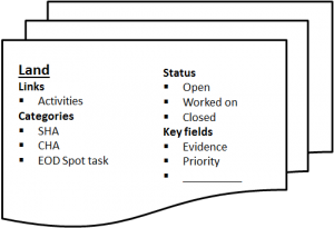
Additionally, information managers can customise the categories so that unused categories can be inactivated and other categories added. The same is true for all top-level items within IMSMANG, which lets information managers specify their exact information model, including the relationships among item categories, and adjust the model as their needs change over time. To accurately map the information model for a Mine Action Programme, it’s helpful to evaluate the available item categories and determine if changes to the information model in IMSMANG are required. While these values can be customised after system setup, understanding the types of information for each item is critical to implementing an effective workflow in IMSMANG.
Example of documentation
Auxiliary Data
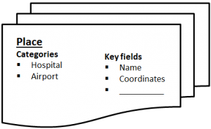
In addition to defining the required information for IMSMANG items, it is important to define the relevant information to be collected about Auxiliary data. This includes defining and documenting the Country Structure, Ordnance classification, Organisation and Place, such as military bases, hospitals and cultural sites; any additional CDFs that should be created; and any subcategories for each of the Auxiliary data types.
Example of Documented Auxiliary Data
Data Entry Forms and Summary items
A Data Entry Form is a template used for data entry of information e.g. about a victim.
The Data Entry Form(s) for a specific object (e.g. the Victim Jane Doe) are summarised and displayed in a Summary.
Reconciliation is the process of deciding if information should update an existing object or creating a new object/Summary.
Or with other words, when a Data Entry process is started the first decision is to choose which of the several different methods/actions for Data Entry to use.
With this approach, users can collect and store multiple Data Entry Forms about the same item over time so that the entire history of the item is preserved in the system. The approach also provides a complete audit trail of all changes made to any information so that information managers can answer the question, "What did we know and when did we know it?"
As subsequent information is collected about a specific attribute of an item, IMSMANG updates the item’s Summary on an attribute-by-attribute basis. The calculation of the Summary is done based on Date of Information and therefore it is important that Date of information is reflecting the age of the information and not the date of entry into IMSMANG.
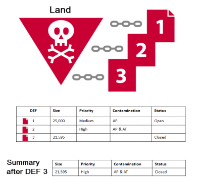
Example of Updating Summary items
Data Entry Form #1 collects some initial information about a Land. It sets the priority to "Medium" and specifies that the land contains AP mines and is 25,000 sqm.
Data Entry Form #2 updates information about the land area after a subsequent assessment. The report sets the priority to "High" and specifies the presence of AP and AT mines, but it does not change the size or the status of the land area.
Data Entry Form #3 updates the land area's size and status after clearance operations are complete. The figure above shows how the land area's Summary is updated after all three reports are entered into the system.
Location
A country's official administrative structure, also known as Gazetteer, should be the base for the Country Structure used in IMSMANG. Sometimes the official administrative structure has not been updated for a long time or it is not detailed enough using it for a geographical placeholder, worksite, for the Mine Action programme and that is why the item Location has been introduced in IMSMANG. Two fundamental decisions to make when customising IMSMANG is to decide what Country Structure level Locations will be consistently linked to and what concept Locations will represent. Typical concepts that a Location is used to represent include:
- a work area (where activities are taking place)
- a community (a group of people affected by the mine/UXO/IED threat)
- the nearest town (the town closest to where the activity is taking place)
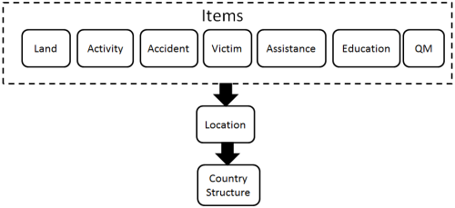
Using Locations, users can group data that belongs together or is associated with each other and in that way get a better overview, facilitate searching and creating reports. The Locations is the link between the Country Structure, whether at the province, district or town level and the Mine Action data. As shown in the figure below, data in IMSMANG are governed by two simple rules:
- all data must be assigned to a Location
- all Locations must be linked to the Country Structure
Using Locations to Link Mine Action Data to the Country Structure
| |
Document the following decisions about Locations:
|
Assigning and Linking
Assigning refers to the assignment of an item to a Location for the purposes of grouping information. All items must be assigned a Location.
Linking refers to the association between items for the purposes of analysis. Linking is optional, for example, when linking Activities to Accidents but linking is very important to do so effective reporting will be possible.
IMSMANG provides the capability to assign items to Locations and create links between items, a function that shows the relationships between items and processes and that enriches the data collected. Assignments and links are defined during the Data Entry Form approval process. An item is assigned to one Location, which ties the item to the country structure and allows for reporting data by area. The same item can then be linked to as many other items as necessary. In this way, IMSMANG supports the idea of linking activities to land, victims to accidents or any item to any other item. When used with item categories, linking adds a powerful capacity to implement an information workflow and create rich and useful data for decision makers. To ensure the integrity of this data, system administrators must clearly specify the kinds of links to track in IMSMANG.
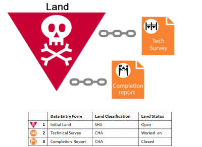
The example below shows how users can build a workflow of relationships among items to model the information management process for their Mine Action Programmes. The figure shows how the Summary changes with each activity that is linked to the original Land.
- The Land starts its life-cycle as SHA with a status of Open in this example.
- When the clearance starts and the first Progress report is linked to the Land, the status should be changed to Worked On.
- Finally, after linking the Completion Report the land's status should be updated to Closed.
The result is one Land whose information is updated over time by the three Activities linked to the land. This way to track information can be used to represent the information management process and status rules accurately for a Land Release, Risk management or other process model.
Example of How Summary Statuses Change
The IMSMANG information model is flexible enough for each Mine Action Programme to customise the system to support its needs. For example, implementations that do not cover Education activities do not need to complete information about Education activities, and they still retain full utility of the system. Similarly, implementations that only cover Victim tracking and Education activities only can disregard Land and Activities without any loss of utility.
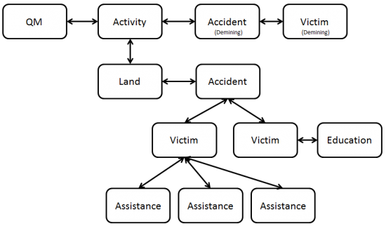
Although any item can be linked to any other item, not all relationships necessarily make sense for every implementation. The diagrams below describe some of the more common logical relationships among items and can serve as the basis for an information model when implementing IMSMANG.
Note: Connections to Country Structure and Location have been omitted from the example
The rationale for each relationship or link should also be documented so the meaning is understood. These relationships are used when entering data to ensure that the links between items are available for searching and reporting, like when searching for all Land that have Accidents linked to them.
The Workbench
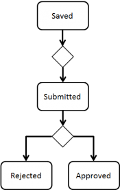
Approval workflow / Data Entry Form Statuses
The Workbench is a holding area / import inbox where Data Entry Forms are found until they are approved. There are four possible steps in the Approval process:
For data quality purposes, it is important that the data is adequately checked. With multiple permission levels for the Approval, different users can be assigned different permissions, allowing Mine Action Programmes to implement a data-entry workflow that distinguishes between data entry and data verification roles.
Until a Data Entry Form is approved, it exists only in the Workbench and does not update any Summary items. The report can still be modified or deleted. The Approval will trigger an update of an existing item (Summary) or creating of a new item depending of chosen Action. If the Summary item has geospatial data, it may be visible in the Map Pane.
| |||||
