Difference between revisions of "Access and Use the Workbench Window"
From IMSMA Wiki
| Line 64: | Line 64: | ||
| width="475pt" | '''Description''' | | width="475pt" | '''Description''' | ||
|- | |- | ||
| − | | align="center" | [[Image: | + | | align="center" | [[Image:25.png]] || Represents the number of field reports in the Workbench. |
|- | |- | ||
| align="center" | [[Image:ColumnsIcon.png]] || Allows you to choose how the columns in the table are displayed. For more information, see the Selecting display columns section on page 143. | | align="center" | [[Image:ColumnsIcon.png]] || Allows you to choose how the columns in the table are displayed. For more information, see the Selecting display columns section on page 143. | ||
Revision as of 20:15, 27 June 2012
| Related Topics |
|---|
| Using IMSMA |
| Field Reports |
| Reconciling Items |
|
Combining Item Record |
| All users will have access to the Workbench window. |
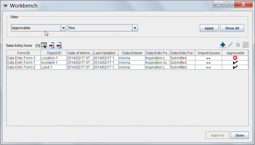
The IMSMA Workbench window lists field reports that were added to IMSMA and need manager approval. There are two ways you can access the Workbench window from the IMSMA Navigation window.
To access the Workbench window from a button:
- Click the
 button next to the GIS map controls toolbar.
- The Workbench window displays (Figure 62).
To access the Workbench window from the menu toolbar:
- From the Data Entry menu, select Field Reports.
- From the Field Reports menu, select View Workbench.
- The Workbench window displays (Figure 62).
Figure 62. Workbench Window
| Table 18. Current View Buttons | |
| Button | Description |
| |
Represents the number of field reports in the Workbench. |
| |
Allows you to choose how the columns in the table are displayed. For more information, see the Selecting display columns section on page 143. |
| File:ExportReportIcon.png | Allows you to export data from the table to an XML or CSV file. For more information, see the Exporting section on page 141. |
| File:ImportIcon.png | Allows you to import a field report for handheld devices in MDML format. For more information, see the How to import a field report from an MDML file section on page 91. |
| File:ExportIcon.png | Allows you to export a field report in MDML format for handheld devices. For more information, see the How to export a field report to an MDML file section on page 91. |
| |
Allows you to export unapproved field reports to an MaXML file. For more information, see the How to export a field report to an MaXML file section on page 91. |
| |
Allows you to view or change a field report. For more information see the How to view or change a field report from the Workbench on page 92. |
| |
Allows you to delete a field report. For more information, see the How to remove a field report from the Workbench section on page 93. |
| |
Allows you to display the geospatial data from field reports on the map. For more information, see the How to display Workbench items on the map section on page 94. |
| -- | Indicates that import issues do not apply to a field report. This icon only appears in the Import Issues column. |
| |
Indicates a field report has an import issue or incomplete reconciliation. This icon can appear in the Import Issues and Approvable columns. |
| |
Indicates a field report has no import issue or incomplete reconciliation. This icon only appears in the Approvable column. |
