Difference between revisions of "Spatial Analysis"
(Created page with "Category:NoPublic {{NavBox Remote Sensing and Spatial Analysis}} Category:PEW") |
|||
| (4 intermediate revisions by 2 users not shown) | |||
| Line 1: | Line 1: | ||
| − | [[ | + | [[Image:800px-Snow-cholera-map.jpg|400px|center]] |
| + | <div align="center"> | ||
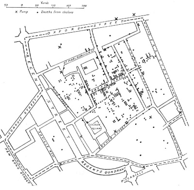
| + | '' Map by [http://en.wikipedia.org/wiki/John_Snow Dr.John Snow], showing clusters of cholera cases in relation to local wells during the [http://en.wikipedia.org/wiki/1854_Broad_Street_cholera_outbreak 1854 Broad Street cholera outbreak]. The analysis was able to identify which well contained contaminated water that had caused the outbreak. This was one of the first uses of map-based spatial analysis.'' | ||
| + | </div><br/> | ||
| + | Spatial Analysis is the process of manipulating spatial information to extract new information and meaning from spatial data. It is a type of geographical analysis done using a GIS which seeks to explain the patterns and relationships between objects or in an area, to better understand and visualize information and data, bringing a holistic understanding of a given situation. | ||
| + | |||
| + | [http://www.spatialanalysisonline.com/output/ Geospatial Analysis - A comprehensive guide] | ||
| + | |||
| + | [http://www.esri.com/products/arcgis-capabilities/spatial-analysis Understanding Spatial Relationships and Patterns] | ||
| + | |||
{{NavBox Remote Sensing and Spatial Analysis}} | {{NavBox Remote Sensing and Spatial Analysis}} | ||
[[Category:PEW]] | [[Category:PEW]] | ||
Latest revision as of 11:57, 11 August 2016
Map by Dr.John Snow, showing clusters of cholera cases in relation to local wells during the 1854 Broad Street cholera outbreak. The analysis was able to identify which well contained contaminated water that had caused the outbreak. This was one of the first uses of map-based spatial analysis.
Spatial Analysis is the process of manipulating spatial information to extract new information and meaning from spatial data. It is a type of geographical analysis done using a GIS which seeks to explain the patterns and relationships between objects or in an area, to better understand and visualize information and data, bringing a holistic understanding of a given situation.
Geospatial Analysis - A comprehensive guide
Understanding Spatial Relationships and Patterns
| |||||||||||
