Difference between revisions of "Display the Area and Length of a Polygon"
From IMSMA Wiki
(Created page with "<table cellspacing="5" cellpadding="0" style="float: right; clear: right; color: black; background: #f9f9f9; border: 1px solid #aaa; width: 22em; margin: 0 0 1.0em 1.0em; padd...") |
|||
| Line 35: | Line 35: | ||
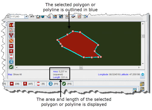
::The selected line or polygon is outlined in blue. The area and/or length displays in the lower, left corner of the map pane. | ::The selected line or polygon is outlined in blue. The area and/or length displays in the lower, left corner of the map pane. | ||
| − | [[Image:fig14.png|center|''Figure 14. Area and Length Example'']] | + | [[Image:fig14.png|center|500px|''Figure 14. Area and Length Example'']] |
<div align="center"> | <div align="center"> | ||
''Figure 14. Area and Length Example'' | ''Figure 14. Area and Length Example'' | ||
</div> | </div> | ||
Revision as of 20:45, 12 June 2012
| Related Topics |
|---|
| Daily Activities |
|
IMSMA Navigation |
| How To Information |
|
Display Item Record Icons |
To display the area and length of a polygon, or the length of a line:
- Zoom in close enough to the icon for which you would like to display the area and length.
- Click the
 button.
 - Select the polygon or line from the map.
- The selected line or polygon is outlined in blue. The area and/or length displays in the lower, left corner of the map pane.
Figure 14. Area and Length Example
