Measure Distance on the Map
Revision as of 13:57, 6 June 2013 by Dionysia (talk | contribs) (moved HowTo:Measure Distance on the Map to Measure Distance on the Map)
The ![]() button allows you to measure lines, polylines, and polygons on the map.
button allows you to measure lines, polylines, and polygons on the map.
To measure distances on the map:
- Click the
 button to enable the measure distance control.
 - Do one of the following:
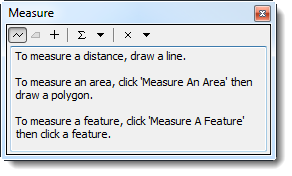
The Measure window displays.
Figure 16. Measure Window
| Table 14. Measure Window Buttons | |
| Button | Description |
| |
Measures a line. |
| |
Measures an area. |
| |
Returns the length, perimeter, area, or coordinates of a feature. |
| File:SnapBtn.png | Snaps to features while measuring. |
| |
Calculates the sum of consecutive measurements. |
| |
Allows you to change the measurement units. |
| |
Clears the measurements. |
- To measure a line, click the
 button.
 - To measure the area and perimeter of a polygon, click the
 button.
| |
The |
- The measurement displays in the Measure window.
