Difference between revisions of "Change the Coordinate Reference System Display"
From IMSMA Wiki
| (11 intermediate revisions by 2 users not shown) | |||
| Line 1: | Line 1: | ||
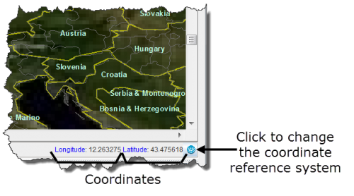
| − | + | The coordinates of the mouse cursor on the map are displayed in the lower, right corner of the map pane. | |
| − | |||
| − | |||
| − | |||
| − | |||
| − | |||
| − | |||
| − | |||
| − | |||
| − | |||
| − | |||
| − | |||
| − | |||
| − | |||
| − | |||
| − | |||
| − | |||
| − | |||
| − | |||
| − | |||
| − | |||
| − | |||
| − | |||
| − | |||
| − | |||
| − | |||
| − | |||
| − | + | [[Image:fig19.png|center|500px|''Coordinates Displayed in the Map Pane'']] | |
| − | |||
| − | [[Image:fig19.png|center|500px|'' | ||
| − | |||
| − | |||
| − | |||
By default, the coordinates display uses the WGS84 reference system. | By default, the coordinates display uses the WGS84 reference system. | ||
| Line 38: | Line 7: | ||
To change the coordinate reference system: | To change the coordinate reference system: | ||
<ol> | <ol> | ||
| − | <li>Click the [[Image:CoordSysIcon.png]] button. | + | <li>Click the [[Image:CoordSysIcon.png]] button. The Coordinate System Selection window displays. |
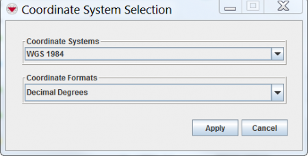
| − | + | [[Image:fig20.png|center|450px|''Coordinate System Selection Window'']] | |
| − | [[Image:fig20.png|center|450px|'' | ||
<div align="center"> | <div align="center"> | ||
| − | '' | + | ''Coordinate System Selection Window'' |
| − | </div> | + | </div></li> |
<li>Select the reference system from the '''Coordinate Systems''' list.</li> | <li>Select the reference system from the '''Coordinate Systems''' list.</li> | ||
<li>Select the format of the coordinates from the '''Coordinate Formats''' list.</li> | <li>Select the format of the coordinates from the '''Coordinate Formats''' list.</li> | ||
<li>Click the '''Apply''' button.</li> | <li>Click the '''Apply''' button.</li> | ||
</ol> | </ol> | ||
| + | |||
| + | {{NavBox HowTo Viewing and Browsing}} | ||
| + | |||
| + | [[Category:CRI]] | ||
Latest revision as of 12:10, 23 March 2015
The coordinates of the mouse cursor on the map are displayed in the lower, right corner of the map pane.
By default, the coordinates display uses the WGS84 reference system.
To change the coordinate reference system:
- Click the
 button. The Coordinate System Selection window displays.
Coordinate System Selection Window
- Select the reference system from the Coordinate Systems list.
- Select the format of the coordinates from the Coordinate Formats list.
- Click the Apply button.

