Difference between revisions of "Control the Page Layout"
From IMSMA Wiki
| (23 intermediate revisions by 6 users not shown) | |||
| Line 1: | Line 1: | ||
| − | + | The page layout button [[Image:AlterLayoutIcon.png]] displays a preview of the map as it would appear when it is printed. It also displays the map layout toolbar. Enabling the map layout mode temporarily disables the country structure pane and the items pane of the IMSMA Navigation window. | |
| − | |||
| − | |||
| − | |||
| − | |||
| − | |||
| − | |||
| − | |||
| − | [[ | ||
| − | |||
| − | |||
| − | |||
| − | |||
| − | |||
| − | |||
| − | |||
| − | |||
| − | |||
| − | |||
| − | |||
| − | |||
| − | |||
| − | |||
| − | |||
| − | |||
| − | |||
| − | |||
| − | + | [[Image:fig21.png|center|400px|''Map Layout View and Toolbar'']] | |
| − | |||
| − | |||
<div align="center"> | <div align="center"> | ||
| − | '' | + | ''Map Layout View and Toolbar'' |
</div> | </div> | ||
| − | { | + | {{note|Clicking the [[Image:AlterLayoutIcon.png]] button again will display the default view of the map.}} |
| − | |||
| − | |||
| − | |||
| − | The buttons in the map layout toolbar and their descriptions are listed in | + | The buttons in the map layout toolbar and their descriptions are listed in the following table. For more information on using these tools, refer to [[Display the Map Layout Shapes Toolbar | Map Layouts]]. |
| + | <center> | ||
{| class="wikitable" width="600" | {| class="wikitable" width="600" | ||
|- | |- | ||
| − | | align="center" colspan="2" | ''' | + | | align="center" colspan="2" | '''Map Layout Toolbar Buttons''' |
|- | |- | ||
| width="125pt" | '''Button''' | | width="125pt" | '''Button''' | ||
| width="475pt" | '''Description''' | | width="475pt" | '''Description''' | ||
|- | |- | ||
| − | | [[Image:AppMapLayIcon.png]] || Allows you to apply a map layout. | + | | align="center" | [[Image:AppMapLayIcon.png]] || Allows you to apply a map layout. |
|- | |- | ||
| − | | [[Image:SaveMapLayIcon.png]] || Allows you to save the map layout. | + | | align="center" | [[Image:SaveMapLayIcon.png]] || Allows you to save the map layout. |
|- | |- | ||
| − | | [[Image:TogLayIcon.png]] || Allows you to toggle between the map layout and the page layout. | + | | align="center" | [[Image:TogLayIcon.png]] || Allows you to toggle between the map layout and the page layout. |
|- | |- | ||
| − | | [[Image:SetSizeIcon.png]] || Allows you to set the paper size, page orientation, and margins. | + | | align="center" | [[Image:SetSizeIcon.png]] || Allows you to set the paper size, page orientation, and margins. |
|- | |- | ||
| − | | [[Image:PrintMapIcon.png]] || Allows you to print the map. | + | | align="center" | [[Image:PrintMapIcon.png]] || Allows you to print the map. |
|- | |- | ||
| − | | [[Image:MovePageIcon.png]] || Allows you to move the page within the map pane. | + | | align="center" | [[Image:MovePageIcon.png]] || Allows you to move the page within the map pane. |
|- | |- | ||
| − | | [[Image:DispLargIcon.png]] || Displays the page at a larger scale. | + | | align="center" | [[Image:DispLargIcon.png]] || Displays the page at a larger scale. |
|- | |- | ||
| − | | [[Image:DispSmallIcon.png]] || Displays the page at a smaller scale. | + | | align="center" | [[Image:DispSmallIcon.png]] || Displays the page at a smaller scale. |
|- | |- | ||
| − | | [[Image:DispSelScaIcon.png]] || Displays the page in the scale selected. | + | | align="center" | [[Image:DispSelScaIcon.png]] || Displays the page in the scale selected. |
|} | |} | ||
| + | </center> | ||
| − | { | + | {{note|While in the map layout view, you can continue to use many of the map control buttons.}} |
| − | + | ||
| − | + | {{NavBox HowTo Viewing and Browsing}} | |
| − | + | ||
| + | [[Category:CRI]] | ||
Latest revision as of 12:12, 23 March 2015
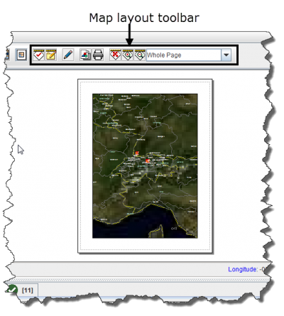
The page layout button ![]() displays a preview of the map as it would appear when it is printed. It also displays the map layout toolbar. Enabling the map layout mode temporarily disables the country structure pane and the items pane of the IMSMA Navigation window.
displays a preview of the map as it would appear when it is printed. It also displays the map layout toolbar. Enabling the map layout mode temporarily disables the country structure pane and the items pane of the IMSMA Navigation window.
Map Layout View and Toolbar
| |
Clicking the |
The buttons in the map layout toolbar and their descriptions are listed in the following table. For more information on using these tools, refer to Map Layouts.
| |
While in the map layout view, you can continue to use many of the map control buttons. |
