Difference between revisions of "Spatial Analysis"
From IMSMA Wiki
| Line 5: | Line 5: | ||
Spatial Analysis is the process of manipulating spatial information to extract new information and meaning from spatial data. It is a type of geographical analysis done using a GIS which seeks to explain the patterns and relationships between objects or in an area, to better understand and visualize information and data, bringing a holistic understanding of a given situation. | Spatial Analysis is the process of manipulating spatial information to extract new information and meaning from spatial data. It is a type of geographical analysis done using a GIS which seeks to explain the patterns and relationships between objects or in an area, to better understand and visualize information and data, bringing a holistic understanding of a given situation. | ||
| − | [http://www.spatialanalysisonline.com/output/ | + | [http://www.spatialanalysisonline.com/output/ Geospatial Analysis - A comprehensive guide] |
[http://www.esri.com/products/arcgis-capabilities/spatial-analysis Understanding Spatial Relationships and Patterns] | [http://www.esri.com/products/arcgis-capabilities/spatial-analysis Understanding Spatial Relationships and Patterns] | ||
Revision as of 12:31, 11 August 2016
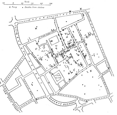
Map by Dr.John Snow, showing clusters of cholera cases in the 1854 Broad Street cholera outbreak. This was one of the first uses of map-based spatial analysis.
Spatial Analysis is the process of manipulating spatial information to extract new information and meaning from spatial data. It is a type of geographical analysis done using a GIS which seeks to explain the patterns and relationships between objects or in an area, to better understand and visualize information and data, bringing a holistic understanding of a given situation.
Geospatial Analysis - A comprehensive guide
Understanding Spatial Relationships and Patterns
| |||||||||||
